
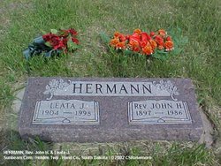
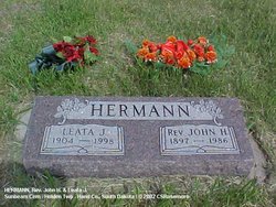
Leata Jane Fisher Hermann
| Birth | : | 2 Jul 1904 Nebraska, USA |
| Death | : | 5 May 1998 Sioux Falls, Minnehaha County, South Dakota, USA |
| Burial | : | Sunbeam Cemetery, Hand County, USA |
| Coordinate | : | 44.6777992, -98.8407974 |
| Plot | : | Blk 2 Lot 3 Grave 3 |
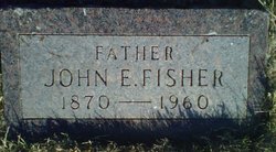
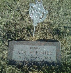
| Description | : | Leata Jane (Fisher) was born July 2, 1904 in Trumbull, Nebraska, the daughter of John E. & Ada M. (Troyer) Fisher. She moved with her family to South Dakota in 1906. She married John M. Hermann December 24, 1921 at St. Lawrence. They served churches at Burdette, near Rockham, then joined the Wesleyan Methodist Conference and served churches in Michigan. They moved back to South Dakota in 1949, serving churches in the Huron area. They lived in St. Lawrence. They retired and moved to Sioux Falls in 1962. After her husband died in 1986, Leata began a... Read More |
frequently asked questions (FAQ):
-
Where is Leata Jane Fisher Hermann's memorial?
Leata Jane Fisher Hermann's memorial is located at: Sunbeam Cemetery, Hand County, USA.
-
When did Leata Jane Fisher Hermann death?
Leata Jane Fisher Hermann death on 5 May 1998 in Sioux Falls, Minnehaha County, South Dakota, USA
-
Where are the coordinates of the Leata Jane Fisher Hermann's memorial?
Latitude: 44.6777992
Longitude: -98.8407974
Family Members:
Parent
Spouse
Siblings

Children
Flowers:


Nearby Cemetories:
1. Sunbeam Cemetery
Hand County, USA
Coordinate: 44.6777992, -98.8407974
2. Burdette Cemetery
Burdette, Hand County, USA
Coordinate: 44.7002983, -98.7869034
3. Beulah Cemetery
Vayland, Hand County, USA
Coordinate: 44.6060982, -98.8060989
4. Buffalo Cemetery
Spink County, USA
Coordinate: 44.6918983, -98.6853027
5. Saint Johns Cemetery
Tulare, Spink County, USA
Coordinate: 44.7202988, -98.6600037
6. Howell Cemetery
Miller, Hand County, USA
Coordinate: 44.7757988, -98.9766998
7. Saint Lawrence Cemetery
Saint Lawrence, Hand County, USA
Coordinate: 44.5292015, -98.9321976
8. Saint Ann's Cemetery
Miller, Hand County, USA
Coordinate: 44.5222015, -98.9732971
9. Cottonwood Cemetery
Redfield, Spink County, USA
Coordinate: 44.8078800, -98.6579600
10. Hillcrest Cemetery
Miller, Hand County, USA
Coordinate: 44.5207000, -99.0006100
11. Alden Cemetery
Hand County, USA
Coordinate: 44.6775017, -99.1203003
12. G A R Cemetery
Miller, Hand County, USA
Coordinate: 44.5078011, -98.9858017
13. Garfield Cemetery
Spink County, USA
Coordinate: 44.6622009, -98.5535965
14. Mount Calvary Cemetery
Polo, Hand County, USA
Coordinate: 44.7827988, -99.1097031
15. Saint Marys Catholic Cemetery
Zell, Faulk County, USA
Coordinate: 44.8943340, -98.7283210
16. Rockham Cemetery
Rockham, Faulk County, USA
Coordinate: 44.9118996, -98.8375015
17. Saint Josephs Catholic Cemetery
Hand County, USA
Coordinate: 44.4574400, -98.7100400
18. Wessington Cemetery
Hand County, USA
Coordinate: 44.4569016, -98.7102966
19. Saint Michaels Cemetery
Hand County, USA
Coordinate: 44.8302994, -99.1106033
20. Tulare Cemetery
Tulare, Spink County, USA
Coordinate: 44.7486000, -98.4922028
21. Prairie View Cemetery
Hand County, USA
Coordinate: 44.8806000, -99.0888977
22. Bonilla Cemetery
Bonilla, Beadle County, USA
Coordinate: 44.5830994, -98.4835968
23. Saint Josephs Cemetery
Orient, Faulk County, USA
Coordinate: 44.9015500, -99.0920300
24. Morningside Cemetery
Ree Heights, Hand County, USA
Coordinate: 44.5147018, -99.1903000