
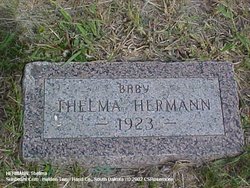
Thelma Jane Hermann
| Birth | : | 17 Apr 1923 Hand County, South Dakota, USA |
| Death | : | 22 Apr 1923 Hand County, South Dakota, USA |
| Burial | : | Sunbeam Cemetery, Hand County, USA |
| Coordinate | : | 44.6777992, -98.8407974 |
| Plot | : | Blk 2 Lot 3 Grave 2 |
| Description | : | Thelma Jane Hermann was born April 17, and died Sunday evening, April 22, 1923. She was the infant daughter of John H. & Leata (Fisher) Hermann, who lifed fifteen miles north of St. Lawrence. Funeral services were held Thursday and burial was made in the Sunbeam Cemetery, Holden Twp., Hand County, SD. |
frequently asked questions (FAQ):
-
Where is Thelma Jane Hermann's memorial?
Thelma Jane Hermann's memorial is located at: Sunbeam Cemetery, Hand County, USA.
-
When did Thelma Jane Hermann death?
Thelma Jane Hermann death on 22 Apr 1923 in Hand County, South Dakota, USA
-
Where are the coordinates of the Thelma Jane Hermann's memorial?
Latitude: 44.6777992
Longitude: -98.8407974
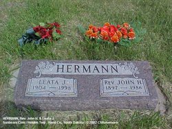
Family Members:
Parent
Siblings

Flowers:


Nearby Cemetories:
1. Sunbeam Cemetery
Hand County, USA
Coordinate: 44.6777992, -98.8407974
2. Burdette Cemetery
Burdette, Hand County, USA
Coordinate: 44.7002983, -98.7869034
3. Beulah Cemetery
Vayland, Hand County, USA
Coordinate: 44.6060982, -98.8060989
4. Buffalo Cemetery
Spink County, USA
Coordinate: 44.6918983, -98.6853027
5. Saint Johns Cemetery
Tulare, Spink County, USA
Coordinate: 44.7202988, -98.6600037
6. Howell Cemetery
Miller, Hand County, USA
Coordinate: 44.7757988, -98.9766998
7. Saint Lawrence Cemetery
Saint Lawrence, Hand County, USA
Coordinate: 44.5292015, -98.9321976
8. Saint Ann's Cemetery
Miller, Hand County, USA
Coordinate: 44.5222015, -98.9732971
9. Cottonwood Cemetery
Redfield, Spink County, USA
Coordinate: 44.8078800, -98.6579600
10. Hillcrest Cemetery
Miller, Hand County, USA
Coordinate: 44.5207000, -99.0006100
11. Alden Cemetery
Hand County, USA
Coordinate: 44.6775017, -99.1203003
12. G A R Cemetery
Miller, Hand County, USA
Coordinate: 44.5078011, -98.9858017
13. Garfield Cemetery
Spink County, USA
Coordinate: 44.6622009, -98.5535965
14. Mount Calvary Cemetery
Polo, Hand County, USA
Coordinate: 44.7827988, -99.1097031
15. Saint Marys Catholic Cemetery
Zell, Faulk County, USA
Coordinate: 44.8943340, -98.7283210
16. Rockham Cemetery
Rockham, Faulk County, USA
Coordinate: 44.9118996, -98.8375015
17. Saint Josephs Catholic Cemetery
Hand County, USA
Coordinate: 44.4574400, -98.7100400
18. Wessington Cemetery
Hand County, USA
Coordinate: 44.4569016, -98.7102966
19. Saint Michaels Cemetery
Hand County, USA
Coordinate: 44.8302994, -99.1106033
20. Tulare Cemetery
Tulare, Spink County, USA
Coordinate: 44.7486000, -98.4922028
21. Prairie View Cemetery
Hand County, USA
Coordinate: 44.8806000, -99.0888977
22. Bonilla Cemetery
Bonilla, Beadle County, USA
Coordinate: 44.5830994, -98.4835968
23. Saint Josephs Cemetery
Orient, Faulk County, USA
Coordinate: 44.9015500, -99.0920300
24. Morningside Cemetery
Ree Heights, Hand County, USA
Coordinate: 44.5147018, -99.1903000