
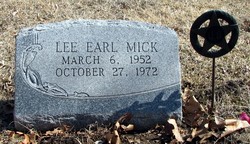
Lee Earl Mick
| Birth | : | 6 Mar 1952 Holton, Jackson County, Kansas, USA |
| Death | : | 27 Oct 1972 |
| Burial | : | Rosebud Cemetery, Glenwood Springs, Garfield County, USA |
| Coordinate | : | 39.5168991, -107.3189011 |
| Plot | : | Section K |
| Description | : | LEE MICK KILLED FRIDAY IN ACCIDENT ON US-75 Lee Earl Mick, 20, was killed instantly Friday night a mile south of Holton on US-75 when he was struck by a car driven by Harold J. Simon, 24, Horton. Mick was walking on the shoulder of the highway when he was hit by the Simon car. Trooper Eugene Stallsmith of the Kansas Highway Patrol who investigated said three vehicles and Mick were involved in the accident. Mick was walking north on the shoulder of the... Read More |
frequently asked questions (FAQ):
-
Where is Lee Earl Mick's memorial?
Lee Earl Mick's memorial is located at: Rosebud Cemetery, Glenwood Springs, Garfield County, USA.
-
When did Lee Earl Mick death?
Lee Earl Mick death on 27 Oct 1972 in
-
Where are the coordinates of the Lee Earl Mick's memorial?
Latitude: 39.5168991
Longitude: -107.3189011
Family Members:
Parent
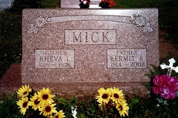
Siblings

Flowers:


Nearby Cemetories:
1. Rosebud Cemetery
Glenwood Springs, Garfield County, USA
Coordinate: 39.5168991, -107.3189011
2. Pioneer Cemetery
Glenwood Springs, Garfield County, USA
Coordinate: 39.5392000, -107.3192000
3. Farnum Holt Columbarium
Glenwood Springs, Garfield County, USA
Coordinate: 39.5469640, -107.3299900
4. Fisher Cemetery
Carbondale, Garfield County, USA
Coordinate: 39.4791985, -107.1911011
5. Evergreen Cemetery
Carbondale, Garfield County, USA
Coordinate: 39.4077988, -107.2155991
6. Marion Cemetery
Garfield County, USA
Coordinate: 39.3689003, -107.3047028
7. Hillcrest Cemetery
Carbondale, Garfield County, USA
Coordinate: 39.3922005, -107.1936035
8. Highland Cemetery
New Castle, Garfield County, USA
Coordinate: 39.5875015, -107.5192032
9. Dotsero Cemetery
Dotsero, Eagle County, USA
Coordinate: 39.6477600, -107.0672200
10. Union Divide Creek Cemetery
Silt, Garfield County, USA
Coordinate: 39.4508018, -107.6200027
11. Skyline Cemetery
Silt, Garfield County, USA
Coordinate: 39.5520060, -107.6575300
12. Basalt Cemetery
Basalt, Eagle County, USA
Coordinate: 39.3646800, -107.0213100
13. Cedar Hill Memorial Cemetery
Gypsum, Eagle County, USA
Coordinate: 39.6445990, -106.9600620
14. Wheatley Cemetery
Pitkin County, USA
Coordinate: 39.3325720, -106.9807170
15. Hillside Cemetery
Redstone, Pitkin County, USA
Coordinate: 39.1843300, -107.2418900
16. Rose Hill Cemetery
Rifle, Garfield County, USA
Coordinate: 39.5381012, -107.7742004
17. Saint Benedicts Monastery Cemetery
Snowmass, Pitkin County, USA
Coordinate: 39.2617000, -107.0038000
18. Sunset View Cemetery
Eagle, Eagle County, USA
Coordinate: 39.6510500, -106.8254400
19. Prospect Mountain Ranch Cemetery
Marble, Gunnison County, USA
Coordinate: 39.0927230, -107.2395980
20. Hidden Valley Cemetery
Snowmass Village, Pitkin County, USA
Coordinate: 39.2200690, -106.9181890
21. Snowmass Village Community Cemetery
Snowmass Village, Pitkin County, USA
Coordinate: 39.2200000, -106.9181000
22. Marble Cemetery
Marble, Gunnison County, USA
Coordinate: 39.0797005, -107.2277985
23. Collins Cemetery
Woody Creek, Pitkin County, USA
Coordinate: 39.2585040, -106.8480060
24. Rulison Cemetery
Rulison, Garfield County, USA
Coordinate: 39.4768000, -107.9357000