

Leland Earl Kuch
| Birth | : | 28 Feb 1935 Benton County, Iowa, USA |
| Death | : | 19 Jun 2012 Amana, Iowa County, Iowa, USA |
| Burial | : | Keystone Cemetery, Keystone, Benton County, USA |
| Coordinate | : | 41.9939003, -92.2172012 |
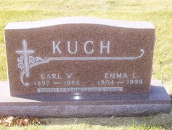
| Description | : | Leland Earl Kuch was born February 28, 1935 to Earl W. and Emma (Newkirk) Kuch of Van Horne. He graduated from the Van Horne High School in 1953 where he was a member of the State Championship Baseball Team in 1952. He continued his love for baseball at Iowa State Teachers College in Cedar Falls (UNI) where he graduated in 1957. Leland taught math, physical education and coached at New Sharon High School. On June 21, 1959, he was united in marriage to Yvonne Hennings at St. John Lutheran Church where he served on the Church Council. ... Read More |
frequently asked questions (FAQ):
-
Where is Leland Earl Kuch's memorial?
Leland Earl Kuch's memorial is located at: Keystone Cemetery, Keystone, Benton County, USA.
-
When did Leland Earl Kuch death?
Leland Earl Kuch death on 19 Jun 2012 in Amana, Iowa County, Iowa, USA
-
Where are the coordinates of the Leland Earl Kuch's memorial?
Latitude: 41.9939003
Longitude: -92.2172012
Family Members:
Parent

Siblings

Flowers:


Nearby Cemetories:
1. Keystone Cemetery
Keystone, Benton County, USA
Coordinate: 41.9939003, -92.2172012
2. Holy Cross Cemetery
Keystone, Benton County, USA
Coordinate: 41.9961014, -92.1825027
3. Van Metre Cemetery
Keystone, Benton County, USA
Coordinate: 41.9614983, -92.1514969
4. Redman Cemetery
Benton County, USA
Coordinate: 41.9710999, -92.2917023
5. Irving Cemetery
Irving, Benton County, USA
Coordinate: 41.9505997, -92.2797012
6. Bender Cemetery
Keystone, Benton County, USA
Coordinate: 42.0363998, -92.1536026
7. Twogood Cemetery
Benton County, USA
Coordinate: 42.0499992, -92.2799988
8. Kirchner Cemetery
Benton County, USA
Coordinate: 42.0727300, -92.2027400
9. Arbuthnot Cemetery
Chelsea, Tama County, USA
Coordinate: 41.9416550, -92.3001787
10. Calvary Cemetery
Van Horne, Benton County, USA
Coordinate: 41.9641991, -92.1138992
11. LaRue Cemetery
Benton County, USA
Coordinate: 42.0574989, -92.1438980
12. Ranstead Cemetery
Luzerne, Benton County, USA
Coordinate: 41.9201622, -92.1613846
13. Wright Cemetery
Belle Plaine, Benton County, USA
Coordinate: 41.9136009, -92.2643967
14. Dvorak Cemetery
Elberon, Tama County, USA
Coordinate: 41.9713000, -92.3417000
15. Waltham Cemetery
Elberon, Tama County, USA
Coordinate: 42.0355988, -92.3328018
16. Big Grove-Homer Cemetery
Benton County, USA
Coordinate: 42.0867004, -92.1821976
17. Lutheran Cemetery
Luzerne, Benton County, USA
Coordinate: 41.8991950, -92.1852390
18. International Cemetery
Luzerne, Benton County, USA
Coordinate: 41.8981018, -92.1800003
19. Oak Hill Cemetery
Belle Plaine, Benton County, USA
Coordinate: 41.8987007, -92.2571030
20. Saint Marys Cemetery
Vining, Tama County, USA
Coordinate: 41.9906000, -92.3556000
21. Beal Pioneer Cemetery
Belle Plaine, Benton County, USA
Coordinate: 41.8903008, -92.2538986
22. Lone Pine Cemetery
Tama County, USA
Coordinate: 42.0797005, -92.3082962
23. National Cemetery
Vining, Tama County, USA
Coordinate: 41.9702988, -92.3705978
24. Roadside Cemetery
Clutier, Tama County, USA
Coordinate: 42.0574800, -92.3548800