
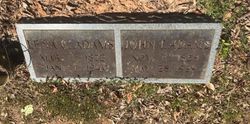
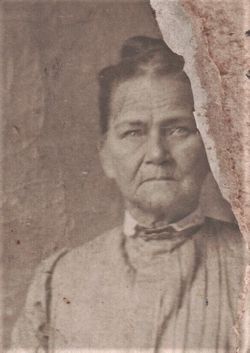
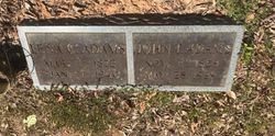
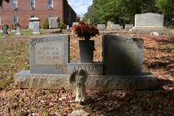
Lena Smith Cook Adams
| Birth | : | 1 Mar 1872 Union County, South Carolina, USA |
| Death | : | 7 Jan 1940 Union County, South Carolina, USA |
| Burial | : | St Mary Churchyard, Hawkshaw, Metropolitan Borough of Bury, England |
| Coordinate | : | 53.6307270, -2.3636210 |
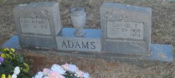
| Description | : | Lena Smith Cook Adams, 67, of Union, SC, died Sunday, January 7, 1940, at her home following an illness of one week. Daughter of the late Smith Cook (1820–1872) and Malinda Cook Adams (1842–1927); wife of the late John Thomas Adams (1859–1929), married July 23, 1893. Survivors include her daughters, Kate Adams Garner (1900–1971) and Frances Mahala Adams Vaughan (1904–1997); seven sons, Robert Smith Adams (1894–1963), Johnnie Ambers Adams (1896–1976), Joseph Franklin Adams (1898–1985), Ruben Bishop Adams (1902–1976), Hoyle Adams (1906–1958), David Talmadge Adams (1908–1984), and Bunyan Welton Adams (1915–1986); one sister, Fannie Charles; brother, Joe... Read More |
frequently asked questions (FAQ):
-
Where is Lena Smith Cook Adams's memorial?
Lena Smith Cook Adams's memorial is located at: St Mary Churchyard, Hawkshaw, Metropolitan Borough of Bury, England.
-
When did Lena Smith Cook Adams death?
Lena Smith Cook Adams death on 7 Jan 1940 in Union County, South Carolina, USA
-
Where are the coordinates of the Lena Smith Cook Adams's memorial?
Latitude: 53.6307270
Longitude: -2.3636210
Family Members:
Parent

Spouse
Children
Flowers:


Nearby Cemetories:
1. St Mary Churchyard
Hawkshaw, Metropolitan Borough of Bury, England
Coordinate: 53.6307270, -2.3636210
2. Hawkshaw Methodist Church Cemetery
Hawkshaw, Metropolitan Borough of Bury, England
Coordinate: 53.6313490, -2.3674190
3. Congregational Churchyard
Affetside, Metropolitan Borough of Bury, England
Coordinate: 53.6175200, -2.3705800
4. Greenmount United Reformed Churchyard
Greenmount, Metropolitan Borough of Bury, England
Coordinate: 53.6254581, -2.3381465
5. St Anne Churchyard
Tottington, Metropolitan Borough of Bury, England
Coordinate: 53.6161499, -2.3409030
6. St. John's Churchyard
Tottington, Metropolitan Borough of Bury, England
Coordinate: 53.6141180, -2.3400670
7. Methodist Church Churchyard
Edgworth, Blackburn with Darwen Unitary Authority, England
Coordinate: 53.6424280, -2.3962830
8. Ramsbottom Cemetery
Ramsbottom, Metropolitan Borough of Bury, England
Coordinate: 53.6372986, -2.3271000
9. St. Anne's Churchyard
Chapeltown, Blackburn with Darwen Unitary Authority, England
Coordinate: 53.6371710, -2.4030440
10. Emmanuel Churchyard
Holcombe, Metropolitan Borough of Bury, England
Coordinate: 53.6463000, -2.3293400
11. Edgworth Congregational Chapelyard
Edgworth, Blackburn with Darwen Unitary Authority, England
Coordinate: 53.6476280, -2.3967210
12. Tottington Road Methodist Church Churchyard
Harwood, Metropolitan Borough of Bolton, England
Coordinate: 53.6079190, -2.3904960
13. Rowlands Methodist Churchyard
Summerseat, Metropolitan Borough of Bury, England
Coordinate: 53.6294360, -2.3102920
14. Harwood Methodist Church Cemetery
Harwood, Metropolitan Borough of Bolton, England
Coordinate: 53.6028240, -2.3903990
15. St. Maxentius Churchyard
Bradshaw, Metropolitan Borough of Bolton, England
Coordinate: 53.6056800, -2.4014800
16. Christ Church Churchyard
Harwood, Metropolitan Borough of Bolton, England
Coordinate: 53.5948860, -2.3821990
17. St. James Churchyard
Bury, Metropolitan Borough of Bury, England
Coordinate: 53.5996770, -2.3214600
18. Christ Church Churchyard
Walmersley, Metropolitan Borough of Bury, England
Coordinate: 53.6193360, -2.2964630
19. Park Chapel
Walmersley, Metropolitan Borough of Bury, England
Coordinate: 53.6205060, -2.2958590
20. Christ Church Churchyard
Bury, Metropolitan Borough of Bury, England
Coordinate: 53.6194570, -2.2960140
21. Ainsworth Unitarian Chapel Cemetery
Metropolitan Borough of Bury, England
Coordinate: 53.5882700, -2.3590390
22. St. John-in-the-Wilderness Churchyard
Shuttleworth, Metropolitan Borough of Bury, England
Coordinate: 53.6556300, -2.3046500
23. Ainsworth Methodist Churchyard
Ainsworth, Metropolitan Borough of Bury, England
Coordinate: 53.5877390, -2.3623810
24. Christ Church Churchyard
Ainsworth, Metropolitan Borough of Bury, England
Coordinate: 53.5875690, -2.3589540