


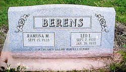
Leo LaVerne Berens
| Birth | : | 7 Sep 1929 Dunlap, Harrison County, Iowa, USA |
| Death | : | 26 Jan 1995 Arnolds Park, Dickinson County, Iowa, USA |
| Burial | : | St. Mary Magdalene Churchyard, Campsall, Metropolitan Borough of Doncaster, England |
| Coordinate | : | 53.6203680, -1.1779620 |
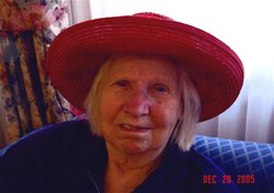
| Description | : | Leo LaVerne Berens was born on Sept. 7, 1929 to William and Mary (Weber) Berens in Dunlap, Iowa. He received his education in Dunlap. Leo was united in marriage to Ramona Mahlberg on Jan 23, 1950 at St. Patrick's Catholic Church in Dunlap. He farmed for many years in the Dunlap area. He later owned and operated the Shamrock Inn in Dunlap. He built and operated the first mini mart in Dunlap. Later he built the steak house in Woodbine called the Round-up Supper Club. Leo made his home in Dunlap most of his life and in 1982, Leo and Ramona started... Read More |
frequently asked questions (FAQ):
-
Where is Leo LaVerne Berens's memorial?
Leo LaVerne Berens's memorial is located at: St. Mary Magdalene Churchyard, Campsall, Metropolitan Borough of Doncaster, England.
-
When did Leo LaVerne Berens death?
Leo LaVerne Berens death on 26 Jan 1995 in Arnolds Park, Dickinson County, Iowa, USA
-
Where are the coordinates of the Leo LaVerne Berens's memorial?
Latitude: 53.6203680
Longitude: -1.1779620
Family Members:
Parent
Spouse
Siblings
Children
Flowers:


Nearby Cemetories:
1. St. Mary Magdalene Churchyard
Campsall, Metropolitan Borough of Doncaster, England
Coordinate: 53.6203680, -1.1779620
2. Campsall New Cemetery
Campsall, Metropolitan Borough of Doncaster, England
Coordinate: 53.6239500, -1.1804250
3. Campsall Old Cemetery
Campsall, Metropolitan Borough of Doncaster, England
Coordinate: 53.6241000, -1.1801000
4. Askern Cemetery
Askern, Metropolitan Borough of Doncaster, England
Coordinate: 53.6187830, -1.1637670
5. St. Peter's Churchyard
Askern, Metropolitan Borough of Doncaster, England
Coordinate: 53.6169240, -1.1524250
6. St. Helen's Churchyard
Burghwallis, Metropolitan Borough of Doncaster, England
Coordinate: 53.6020620, -1.1899730
7. All Saints Churchyard
Owston, Metropolitan Borough of Doncaster, England
Coordinate: 53.5942161, -1.1691935
8. St Peter Churchyard
Kirk Smeaton, Selby District, England
Coordinate: 53.6436580, -1.2148560
9. St. Michael's Churchyard
Skelbrooke, Metropolitan Borough of Doncaster, England
Coordinate: 53.6029400, -1.2293000
10. All Saints Church
Moss, Metropolitan Borough of Doncaster, England
Coordinate: 53.6079090, -1.1176700
11. St. John's Churchyard
Fenwick, Metropolitan Borough of Doncaster, England
Coordinate: 53.6284191, -1.1091576
12. St Martin Churchyard
Womersley, Selby District, England
Coordinate: 53.6646000, -1.1959000
13. Redhouse Lane Cemetery
Adwick le Street, Metropolitan Borough of Doncaster, England
Coordinate: 53.5762650, -1.1989510
14. Red House Cemetery
Brodsworth, Metropolitan Borough of Doncaster, England
Coordinate: 53.5761770, -1.1990350
15. Womersley Cemetery
Womersley, Selby District, England
Coordinate: 53.6655100, -1.1967300
16. Hampole Priory
Hampole, Metropolitan Borough of Doncaster, England
Coordinate: 53.5876700, -1.2373620
17. St. Laurence Churchyard
Adwick le Street, Metropolitan Borough of Doncaster, England
Coordinate: 53.5710200, -1.1846150
18. Windmill Balk Lane Cemetery
Adwick le Street, Metropolitan Borough of Doncaster, England
Coordinate: 53.5662610, -1.1913080
19. St John the Evangelist Churchyard
Wentbridge, Metropolitan Borough of Wakefield, England
Coordinate: 53.6507600, -1.2591930
20. St. Margaret's Churchyard
North Elmsall, Metropolitan Borough of Wakefield, England
Coordinate: 53.6091690, -1.2810510
21. St. Mary the Virgin Churchyard
South Elmsall, Metropolitan Borough of Wakefield, England
Coordinate: 53.5934950, -1.2861930
22. Saint Michael and All Angels Churchyard
Brodsworth, Metropolitan Borough of Doncaster, England
Coordinate: 53.5591500, -1.2365300
23. St. Mary's Churchyard
Kirk Bramwith, Metropolitan Borough of Doncaster, England
Coordinate: 53.5985711, -1.0637691
24. All Saints Churchyard
Arksey, Metropolitan Borough of Doncaster, England
Coordinate: 53.5557580, -1.1271520