
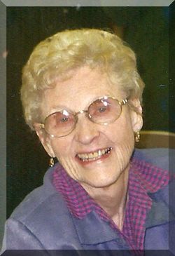
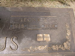
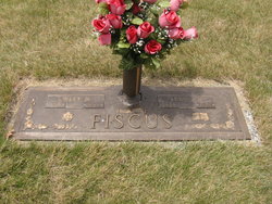
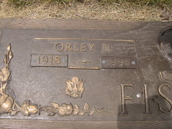
Leona Etta “Lee” Goecke Fiscus
| Birth | : | 19 Jan 1918 Marshall County, Iowa, USA |
| Death | : | 7 Mar 2008 Marshalltown, Marshall County, Iowa, USA |
| Burial | : | Old Farm Cemetery, Shag Harbour, Shelburne County, Canada |
| Coordinate | : | 43.4985969, -65.7252369 |
| Description | : | *** IN LOVING MEMORY OF *** Leona "Lee" Etta (Goecke) Fiscus was born Saturday; January 19, 1918 in rural Marshall County, Iowa. She was the daughter of Beulah (Dewhirst) Goecke and Albert L. Goecke. She attended the one room school house, Hurricane School #5 through the 7th grade, transferring to Clemons School in 8th grade and graduating in 1935. After graduation she moved to Marshalltown; Marshall County, Iowa and worked for the Kresge's Dollar Store. Later she moved to Cedar Rapids and worked for the Collins Radio Company during and after World War II. She married Orley Fiscus in... Read More |
frequently asked questions (FAQ):
-
Where is Leona Etta “Lee” Goecke Fiscus's memorial?
Leona Etta “Lee” Goecke Fiscus's memorial is located at: Old Farm Cemetery, Shag Harbour, Shelburne County, Canada.
-
When did Leona Etta “Lee” Goecke Fiscus death?
Leona Etta “Lee” Goecke Fiscus death on 7 Mar 2008 in Marshalltown, Marshall County, Iowa, USA
-
Where are the coordinates of the Leona Etta “Lee” Goecke Fiscus's memorial?
Latitude: 43.4985969
Longitude: -65.7252369
Family Members:
Spouse
Children
Flowers:


Nearby Cemetories:
1. Old Farm Cemetery
Shag Harbour, Shelburne County, Canada
Coordinate: 43.4985969, -65.7252369
2. Central Woods Harbour Cemetery
Central Woods Harbour, Shelburne County, Canada
Coordinate: 43.5335700, -65.7277500
3. Greenwood Cemetery
Lower Woods Harbour, Shelburne County, Canada
Coordinate: 43.5336390, -65.7279050
4. Birch Hill Cemetery
Shelburne, Shelburne County, Canada
Coordinate: 43.4990405, -65.6608886
5. Atwoods Brook Cemetery - Old
Atwoods Brook, Shelburne County, Canada
Coordinate: 43.5036110, -65.6611110
6. Forbes Family Cemetery
Forbes Point, Shelburne County, Canada
Coordinate: 43.5542950, -65.7495750
7. Old Nickerson Family Graveyard
Central Woods Harbour, Shelburne County, Canada
Coordinate: 43.5572300, -65.7392110
8. Lyons Family Cemetery
Forbes Point, Shelburne County, Canada
Coordinate: 43.5536770, -65.7646980
9. Mount Pleasant Cemetery
Woods Harbour, Shelburne County, Canada
Coordinate: 43.5672500, -65.7378200
10. United Baptist Church Cemetery
Barrington Passage, Shelburne County, Canada
Coordinate: 43.5192870, -65.6316240
11. Green Grove Cemetery
Charlesville, Shelburne County, Canada
Coordinate: 43.5740390, -65.7711530
12. Green Grove Cemetery
Argyle Sound, Yarmouth County, Canada
Coordinate: 43.5740390, -65.7711530
13. Centreville Cemetery
Centreville, Shelburne County, Canada
Coordinate: 43.4842510, -65.6117500
14. Forest Hill Cemetery
Barrington Passage, Shelburne County, Canada
Coordinate: 43.5275000, -65.6091670
15. Oakvale Cemetery
Clarks Harbour, Shelburne County, Canada
Coordinate: 43.4429200, -65.6249000
16. Old Morrisey Cemetery
Lower East Pubnico, Yarmouth County, Canada
Coordinate: 43.5943800, -65.7779800
17. Hillside Cemetery
Barrington, Shelburne County, Canada
Coordinate: 43.5520000, -65.6014667
18. Atlantic Cemetery
Stoney Island, Shelburne County, Canada
Coordinate: 43.4681600, -65.5755600
19. River Dale Cemetery
Riverhead, Shelburne County, Canada
Coordinate: 43.5709930, -65.5878290
20. Barrington River Cemetery
Barrington, Shelburne County, Canada
Coordinate: 43.5667700, -65.5797000
21. Villagedale Cemetery
Villagedale, Shelburne County, Canada
Coordinate: 43.5379720, -65.5476840
22. Old Acadian Cemetery
Lower West Pubnico, Yarmouth County, Canada
Coordinate: 43.6364960, -65.7944150
23. Ponds Cemetery
Port La Tour, Shelburne County, Canada
Coordinate: 43.4977020, -65.5054660
24. Saint-Pierre Parish Cemetery
Middle West Pubnico, Yarmouth County, Canada
Coordinate: 43.6550000, -65.8033600