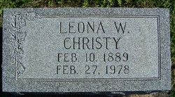
Leona W. Dildine Christy
| Birth | : | 10 Feb 1890 Vigo County, Indiana, USA |
| Death | : | 27 Feb 1978 Terre Haute, Vigo County, Indiana, USA |
| Burial | : | Chandler Hill Cemetery, Bethel, Oxford County, USA |
| Coordinate | : | 44.4392014, -70.7394028 |
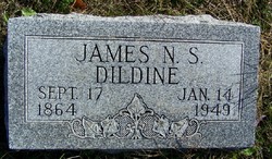
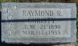
| Description | : | Services for Leona W. Christy, 89, 76 Marigold Drive, who died Monday evening at her residence, will be held 1:30 p.m. Friday at Ball-Porter Funeral Home with burial to follow at Oak Hill Cemetery, Riley. Friends may call after 4 p.m., Thursday. She was a member of Lost Creek Home Ec Club and Vigo County Conservation Club Auxillary. Leona is preceded in death by her parents, James E. Dildine & Isabell Wells and her husband, Raymond R. Christy. Surviving are a son, Richard Eugene of Terre Haute, a daughter, Mrs. Marjorie Jones of Abiline, TX, six grandchildren and... Read More |
frequently asked questions (FAQ):
-
Where is Leona W. Dildine Christy's memorial?
Leona W. Dildine Christy's memorial is located at: Chandler Hill Cemetery, Bethel, Oxford County, USA.
-
When did Leona W. Dildine Christy death?
Leona W. Dildine Christy death on 27 Feb 1978 in Terre Haute, Vigo County, Indiana, USA
-
Where are the coordinates of the Leona W. Dildine Christy's memorial?
Latitude: 44.4392014
Longitude: -70.7394028
Family Members:
Parent
Spouse
Siblings
Flowers:
Nearby Cemetories:
1. Chandler Hill Cemetery
Bethel, Oxford County, USA
Coordinate: 44.4392014, -70.7394028
2. South Bethel Cemetery
Bethel, Oxford County, USA
Coordinate: 44.4160995, -70.7363968
3. East Bethel Cemetery
East Bethel, Oxford County, USA
Coordinate: 44.4648500, -70.7210200
4. Bird Hill Cemetery
Bethel, Oxford County, USA
Coordinate: 44.4234140, -70.6961680
5. Capen Family Cemetery
Bethel, Oxford County, USA
Coordinate: 44.4382283, -70.7925117
6. Middle Intervale Cemetery
Bethel, Oxford County, USA
Coordinate: 44.4638600, -70.7866200
7. Bartlett Cemetery
East Bethel, Oxford County, USA
Coordinate: 44.4817009, -70.7433014
8. Mount Abram Cemetery
Greenwood, Oxford County, USA
Coordinate: 44.4025002, -70.7078018
9. Hanover Cemetery
Hanover, Oxford County, USA
Coordinate: 44.4850006, -70.7332993
10. Riverside Cemetery
Bethel, Oxford County, USA
Coordinate: 44.4202995, -70.8058014
11. Mount Will Cemetery
North Bethel, Oxford County, USA
Coordinate: 44.4636002, -70.8028030
12. Howe Hill Cemetery
Greenwood, Oxford County, USA
Coordinate: 44.3856010, -70.7142029
13. Black Family Cemetery
Newry, Oxford County, USA
Coordinate: 44.4889670, -70.7895730
14. Woodland Cemetery
Bethel, Oxford County, USA
Coordinate: 44.3902283, -70.7967911
15. Scribner Hill Cemetery Upper Yard
Otisfield, Oxford County, USA
Coordinate: 44.3903181, -70.7978794
16. Skillingston Cemetery
Bethel, Oxford County, USA
Coordinate: 44.4085999, -70.8197021
17. Whales Back Cemetery
Woodstock, Oxford County, USA
Coordinate: 44.4202200, -70.6507100
18. Rumford Corner Cemetery
Rumford Corner, Oxford County, USA
Coordinate: 44.4955200, -70.6762500
19. Rumford Point Cemetery
Rumford Point, Oxford County, USA
Coordinate: 44.5020760, -70.6725600
20. Abbott Mills Cemetery
Rumford, Oxford County, USA
Coordinate: 44.4750600, -70.6391900
21. Cole Hill Cemetery
Woodstock, Oxford County, USA
Coordinate: 44.3992004, -70.6350021
22. Old Powers Cemetery
Newry, Oxford County, USA
Coordinate: 44.5031013, -70.8178024
23. Cole Cemetery
Greenwood, Oxford County, USA
Coordinate: 44.3638400, -70.6729000
24. Sunday River Cemetery
Newry, Oxford County, USA
Coordinate: 44.4888992, -70.8431015

