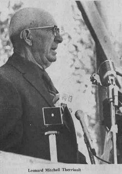
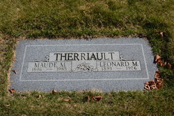
Leonard Mitchell Therriault
| Birth | : | 7 Feb 1895 Kalispell, Flathead County, Montana, USA |
| Death | : | 7 Nov 1976 Spokane, Spokane County, Washington, USA |
| Burial | : | Cherry Grove Cemetery, Xenia, Greene County, USA |
| Coordinate | : | 39.6810989, -83.9477997 |
| Description | : | Leonard Therriault - community leader and promoter dies Leonard Mitchell Therriault, 81, area pioneer, businessman and community leader died Sunday in a Spokane hospital where he had undergone heart surgery a week before. He had operated a variety of businesses in the Methow Valley, Pateros and Brewster and was active in politics at the county and state level. He was an active community leader in Pateros and Brewster, and was well-known for his interest in promoting the North Cascade Highway, Alta Lake State Park and the Watergrade Highway. Leonard Therriault is survived by his wife, Maude, Brewster; one son, Dell Therriault, Wenatchee; one daughter,... Read More |
frequently asked questions (FAQ):
-
Where is Leonard Mitchell Therriault's memorial?
Leonard Mitchell Therriault's memorial is located at: Cherry Grove Cemetery, Xenia, Greene County, USA.
-
When did Leonard Mitchell Therriault death?
Leonard Mitchell Therriault death on 7 Nov 1976 in Spokane, Spokane County, Washington, USA
-
Where are the coordinates of the Leonard Mitchell Therriault's memorial?
Latitude: 39.6810989
Longitude: -83.9477997
Family Members:
Parent
Spouse
Siblings
Children
Flowers:
Nearby Cemetories:
1. Cherry Grove Cemetery
Xenia, Greene County, USA
Coordinate: 39.6810989, -83.9477997
2. Woodland Cemetery
Xenia, Greene County, USA
Coordinate: 39.6885986, -83.9400024
3. Saint Brigid Cemetery
Xenia, Greene County, USA
Coordinate: 39.6828003, -83.9630966
4. Associate Church Cemetery (Defunct)
Xenia, Greene County, USA
Coordinate: 39.6858860, -83.9334690
5. Tornado Victims Memorial Plaque
Xenia, Greene County, USA
Coordinate: 39.6862490, -83.9293760
6. Ohio Veterans Childrens Home Cemetery
Xenia, Greene County, USA
Coordinate: 39.6710243, -83.9232330
7. Gowdy Associate Reformed Cemetery
Xenia, Greene County, USA
Coordinate: 39.6835938, -83.9194183
8. East Church Street Cemetery (Defunct)
Xenia, Greene County, USA
Coordinate: 39.6879340, -83.9199990
9. Methodist Cemetery (Defunct)
Xenia, Greene County, USA
Coordinate: 39.6840640, -83.9184530
10. Bonner Family Cemetery
Xenia, Greene County, USA
Coordinate: 39.6561500, -83.9393500
11. Allen-Hawkins Cemetery
Xenia, Greene County, USA
Coordinate: 39.7040825, -83.9632263
12. Stand Pipe Cemetery
Xenia, Greene County, USA
Coordinate: 39.6873500, -83.9113330
13. Forsman Cemetery
Xenia, Greene County, USA
Coordinate: 39.6955500, -83.9147300
14. Davis Cemetery (Defunct)
Xenia, Greene County, USA
Coordinate: 39.6518830, -83.9216730
15. Hedges Road Stone
Xenia, Greene County, USA
Coordinate: 39.6499460, -83.9706150
16. Valley View Memorial Gardens
Xenia, Greene County, USA
Coordinate: 39.6935997, -83.9957962
17. Andrews Farm Cemetery
Xenia, Greene County, USA
Coordinate: 39.7158630, -83.9728760
18. Heath Cemetery
Xenia, Greene County, USA
Coordinate: 39.6498489, -83.9073486
19. Loyd Cemetery
Xenia, Greene County, USA
Coordinate: 39.6480000, -83.9019000
20. Rich Cemetery
Xenia, Greene County, USA
Coordinate: 39.6316390, -83.9339140
21. Maxey Cemetery
Xenia, Greene County, USA
Coordinate: 39.6333110, -83.9201500
22. Beavercreek Township Cemetery
Beavercreek, Greene County, USA
Coordinate: 39.7123146, -84.0097351
23. House Family Cemetery
Xenia, Greene County, USA
Coordinate: 39.7217789, -83.8937454
24. Bell Cemetery
Xenia Township, Greene County, USA
Coordinate: 39.6453018, -83.8865967

