
| Birth | : | 29 May 1928 Rushville, Sheridan County, Nebraska, USA |
| Death | : | 15 Nov 2011 Scottsbluff, Scotts Bluff County, Nebraska, USA |
| Burial | : | Calvary Cemetery, Alliance, Box Butte County, USA |
| Coordinate | : | 42.1264000, -102.8569031 |
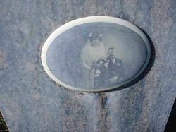
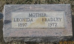
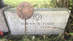
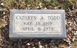
| Description | : | LEONIDA "BILLIE" CHRISTENSEN May 29, 1928 - November 15, 2011 Leonida J. (Billie) Christensen died Tuesday, November 15, at Regional West Medical Center in Scottsbluff, Nebraska. She was born May 29, 1928 in Rushville, NE to Joseph and Leonida (Chamberlain) Koller. She was 83. She was raised on the homestead south of Rushville and attended school in Rushville and in Sidney, Nebraska. On May 25, 1945 she married Elwyn R. Todd at the homestead where she was born and raised. In 1955, they moved to Alliance where they made their home. They owned and operated Don's Cafe in Alliance from 1965 until... Read More |
frequently asked questions (FAQ):
-
Where is Leonida Juanetta “Billie” Koller Christensen's memorial?
Leonida Juanetta “Billie” Koller Christensen's memorial is located at: Calvary Cemetery, Alliance, Box Butte County, USA.
-
When did Leonida Juanetta “Billie” Koller Christensen death?
Leonida Juanetta “Billie” Koller Christensen death on 15 Nov 2011 in Scottsbluff, Scotts Bluff County, Nebraska, USA
-
Where are the coordinates of the Leonida Juanetta “Billie” Koller Christensen's memorial?
Latitude: 42.1264000
Longitude: -102.8569031
Family Members:
Parent
Spouse

Siblings
Flowers:


Nearby Cemetories:
1. Calvary Cemetery
Alliance, Box Butte County, USA
Coordinate: 42.1264000, -102.8569031
2. Saint Johns United Lutheran Church Columbarium
Alliance, Box Butte County, USA
Coordinate: 42.1178900, -102.8794100
3. Saint Matthews Episcopal Church Columbarium
Alliance, Box Butte County, USA
Coordinate: 42.1106300, -102.8748000
4. Alliance Cemetery
Alliance, Box Butte County, USA
Coordinate: 42.1104965, -102.8367996
5. Immanuel Lutheran Church Columbarium
Alliance, Box Butte County, USA
Coordinate: 42.1053100, -102.8711700
6. United Methodist Church Columbarium
Alliance, Box Butte County, USA
Coordinate: 42.1013300, -102.8710400
7. Nebraska Veterans Cemetery
Alliance, Box Butte County, USA
Coordinate: 42.0745700, -102.8182800
8. Letan Cemetery
Letan, Box Butte County, USA
Coordinate: 42.0162290, -102.9367660
9. Fairview Cemetery
Alliance, Box Butte County, USA
Coordinate: 42.2409160, -102.7879280
10. Evergreen Cemetery
Alliance, Box Butte County, USA
Coordinate: 42.0244000, -103.0542000
11. Saint Johns Lutheran Cemetery
Hemingford, Box Butte County, USA
Coordinate: 42.2785520, -103.0046210
12. Antioch Cemetery
Sheridan County, USA
Coordinate: 42.0661480, -102.5874600
13. Nonpareil Cemetery
Hemingford, Box Butte County, USA
Coordinate: 42.2631149, -103.0824258
14. Hemingford Cemetery
Hemingford, Box Butte County, USA
Coordinate: 42.3125000, -103.0541992
15. Pioneer-Box Butte Cemetery
Box Butte County, USA
Coordinate: 42.3640700, -102.8502400
16. Katen Cemetery
Box Butte County, USA
Coordinate: 42.4267006, -102.8908005
17. Snake Creek Cemetery
Box Butte County, USA
Coordinate: 42.0889015, -103.2742004
18. Lakeside Cemetery
Lakeside, Sheridan County, USA
Coordinate: 42.0529850, -102.4274100
19. Neely Flat Cemetery
Sheridan County, USA
Coordinate: 42.4000015, -102.5958023
20. Angora Cemetery
Angora, Morrill County, USA
Coordinate: 41.8577995, -103.1306000
21. Ball Cemetery
Hemingford, Box Butte County, USA
Coordinate: 42.3372300, -103.2293300
22. Saint Peters Cemetery
Sheridan County, USA
Coordinate: 42.4975014, -102.7161026
23. Lawn Cemetery
Box Butte County, USA
Coordinate: 42.3224630, -103.3083830
24. Bohemian Pioneer Cemetery
Box Butte County, USA
Coordinate: 42.2946300, -103.3862200