
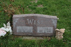
Leota Marie Howard West
| Birth | : | 19 Mar 1915 |
| Death | : | 19 Feb 1999 |
| Burial | : | Salem Cemetery, Adams County, USA |
| Coordinate | : | 40.9467010, -94.5843964 |
frequently asked questions (FAQ):
-
Where is Leota Marie Howard West's memorial?
Leota Marie Howard West's memorial is located at: Salem Cemetery, Adams County, USA.
-
When did Leota Marie Howard West death?
Leota Marie Howard West death on 19 Feb 1999 in
-
Where are the coordinates of the Leota Marie Howard West's memorial?
Latitude: 40.9467010
Longitude: -94.5843964
Family Members:
Parent

Siblings
Children
Flowers:


Nearby Cemetories:
1. Salem Cemetery
Adams County, USA
Coordinate: 40.9467010, -94.5843964
2. Stringtown Cemetery
Stringtown, Adams County, USA
Coordinate: 40.9796982, -94.5663986
3. North Fairview Cemetery
Lenox, Taylor County, USA
Coordinate: 40.8824997, -94.5753021
4. West Fairview Cemetery
Lenox, Taylor County, USA
Coordinate: 40.8786011, -94.5744019
5. Fairview Cemetery
Lenox, Taylor County, USA
Coordinate: 40.8788986, -94.5699997
6. Icarian Cemetery
Corning, Adams County, USA
Coordinate: 40.9901000, -94.6726000
7. Evergreen Cemetery
Prescott, Adams County, USA
Coordinate: 41.0299988, -94.6136017
8. Old Evergreen Cemetery
Prescott, Adams County, USA
Coordinate: 41.0321500, -94.6051500
9. Summit Cemetery
Prescott, Adams County, USA
Coordinate: 41.0283012, -94.5291977
10. Grove Cemetery
Taylor County, USA
Coordinate: 40.8555984, -94.6438980
11. Morgan Cemetery
Kent, Union County, USA
Coordinate: 40.9080009, -94.4520035
12. Old Queen City Cemetery
Corning, Adams County, USA
Coordinate: 41.0078700, -94.7093200
13. Calvary Cemetery
Corning, Adams County, USA
Coordinate: 40.9763000, -94.7350000
14. Oak Hill Cemetery
Corning, Adams County, USA
Coordinate: 40.9763985, -94.7367020
15. Tando-Winslow Cemetery
Sharpsburg, Taylor County, USA
Coordinate: 40.8277740, -94.6051600
16. Walnut Grove Cemetery
Corning, Adams County, USA
Coordinate: 40.9989000, -94.7407000
17. McDuffie Cemetery
Kent, Union County, USA
Coordinate: 40.9500008, -94.4110031
18. Mount Pleasant Cemetery
Adams County, USA
Coordinate: 41.0508003, -94.6900024
19. Cromwell Cemetery
Cromwell, Union County, USA
Coordinate: 41.0456543, -94.4616928
20. Lytles Grove Cemetery
Cromwell, Union County, USA
Coordinate: 41.0190010, -94.4309998
21. Bruning Cemetery
Kent, Union County, USA
Coordinate: 40.9049988, -94.4069977
22. Mount Zion Cemetery
Adams County, USA
Coordinate: 41.0863991, -94.6031036
23. Old Brooks Cemetery
Corning, Adams County, USA
Coordinate: 40.9833196, -94.7669190
24. Grove Chapel Cemetery
Kent, Union County, USA
Coordinate: 40.9350110, -94.3947670