
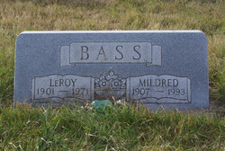
LeRoy Bass
| Birth | : | 8 Mar 1901 Boone County, Iowa, USA |
| Death | : | 7 Jul 1971 Boone, Boone County, Iowa, USA |
| Burial | : | East Winton Cemetery, Winton, Southland District, New Zealand |
| Coordinate | : | -46.1374640, 168.3557030 |
| Description | : | Boone News Republican July 8, 1971 LeRoy Bass, 70, Stratford Stratford (Special) - LeRoy Bass, 70, of Stratford, died Wednesday, July 7, at the Boone County Hospital after suffering a heart attack. He farmed in the Stratford community for a number of years and then was custodian of the Stratford Schools from 1954 until 1967, when he retired. Mr. Bass, son of Mr. and Mrs. Stephen Douglas Bass was born March 8, 1901 in Boone County. He was married to Mildred Waller on Feb. 26, 1925 at Ridgeport. Survivors include his widow, Mildred; 2 sons, Carl... Read More |
frequently asked questions (FAQ):
-
Where is LeRoy Bass's memorial?
LeRoy Bass's memorial is located at: East Winton Cemetery, Winton, Southland District, New Zealand.
-
When did LeRoy Bass death?
LeRoy Bass death on 7 Jul 1971 in Boone, Boone County, Iowa, USA
-
Where are the coordinates of the LeRoy Bass's memorial?
Latitude: -46.1374640
Longitude: 168.3557030
Family Members:
Parent

Spouse

Siblings
Children
Flowers:


Nearby Cemetories:
1. East Winton Cemetery
Winton, Southland District, New Zealand
Coordinate: -46.1374640, 168.3557030
2. Winton Cemetery
Winton, Southland District, New Zealand
Coordinate: -46.1289300, 168.3250400
3. Forest Hill Cemetery
Southland District, New Zealand
Coordinate: -46.2049720, 168.3969970
4. Ryal Bush
Ryal Bush, Southland District, New Zealand
Coordinate: -46.2836700, 168.3256000
5. Calcium Cemetery
Isla Bank, Southland District, New Zealand
Coordinate: -46.2035710, 168.1279070
6. Wallacetown Old Cemetery
Wallacetown, Southland District, New Zealand
Coordinate: -46.3321840, 168.2861670
7. Wallacetown New Cemetery
Wallacetown, Southland District, New Zealand
Coordinate: -46.3374900, 168.2835700
8. Wreys Bush Cemetery
Wreys Bush, Southland District, New Zealand
Coordinate: -45.9941900, 168.0974500
9. Saint Johns Cemetery
Invercargill, Invercargill City, New Zealand
Coordinate: -46.3748600, 168.3431480
10. Dipton Cemetery
Dipton, Southland District, New Zealand
Coordinate: -45.8957730, 168.3508000
11. Otautau New Cemetery
Otautau, Southland District, New Zealand
Coordinate: -46.1307300, 168.0066400
12. Otautau Old Cemetery
Otautau, Southland District, New Zealand
Coordinate: -46.1471300, 167.9940500
13. All Saints Anglican Church
Invercargill, Invercargill City, New Zealand
Coordinate: -46.3906042, 168.3476728
14. Woodlands Cemetery
Woodlands, Southland District, New Zealand
Coordinate: -46.3568800, 168.5463770
15. Holy Trinity Anglican Church
Invercargill, Invercargill City, New Zealand
Coordinate: -46.3984736, 168.3660057
16. Eastern Cemetery
Invercargill, Invercargill City, New Zealand
Coordinate: -46.4070770, 168.3961480
17. Southland Crematorium
Invercargill, Invercargill City, New Zealand
Coordinate: -46.4109100, 168.3961330
18. Te Hau Mutunga Urupā
Invercargill, Invercargill City, New Zealand
Coordinate: -46.4288704, 168.4148361
19. Wairio Cemetery
Nightcaps, Southland District, New Zealand
Coordinate: -45.9617230, 168.0078750
20. Riverton Cemetery
Riverton, Southland District, New Zealand
Coordinate: -46.3316900, 168.0215500
21. Edendale Cemetery
Edendale, Southland District, New Zealand
Coordinate: -46.3080400, 168.7327360
22. Riversdale Cemetery
Riversdale, Southland District, New Zealand
Coordinate: -45.9180100, 168.7263600
23. Balfour Cemetery
Balfour, Southland District, New Zealand
Coordinate: -45.8391000, 168.5986640
24. Mataura Cemetery
Mataura, Gore District, New Zealand
Coordinate: -46.2016960, 168.8808060