
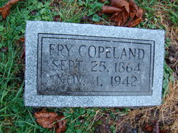
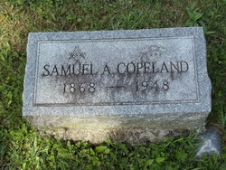
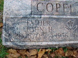
Leslie Fry Copeland
| Birth | : | 25 Sep 1864 Harrison County, Ohio, USA |
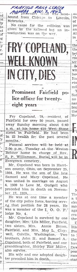
| Death | : | 1 Nov 1942 Fairfield, Jefferson County, Iowa, USA |
| Burial | : | Lockney Cemetery, Lockney, Floyd County, USA |
| Coordinate | : | 34.1340620, -101.4267910 |
| Plot | : | Old.P.311 |
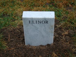
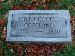
| Description | : | The full given name is believed to by Leslie Fry Copeland, though he evidently went by "Fry" Copeland in life. Married first to Elinor (a/k/a Eleanor) Smith Copeland, then to Love M Gudgell Copeland. Note: the adopted "daughter" mentioned in the obituary, Ocean Irene Gudgell, was actually a sister of Love. Not known are the circumstances that led to the adoption - perhaps some sort of family issues that led to the adoption? |
frequently asked questions (FAQ):
-
Where is Leslie Fry Copeland's memorial?
Leslie Fry Copeland's memorial is located at: Lockney Cemetery, Lockney, Floyd County, USA.
-
When did Leslie Fry Copeland death?
Leslie Fry Copeland death on 1 Nov 1942 in Fairfield, Jefferson County, Iowa, USA
-
Where are the coordinates of the Leslie Fry Copeland's memorial?
Latitude: 34.1340620
Longitude: -101.4267910
Family Members:
Parent
Spouse
Siblings
Flowers:


Nearby Cemetories:
1. Lockney Cemetery
Lockney, Floyd County, USA
Coordinate: 34.1340620, -101.4267910
2. Irick Cemetery
Aiken, Floyd County, USA
Coordinate: 34.0884300, -101.5083090
3. Della Plain Cemetery
Floydada, Floyd County, USA
Coordinate: 34.0674460, -101.3217040
4. Floydada Cemetery
Floydada, Floyd County, USA
Coordinate: 34.0058000, -101.3265300
5. Floyd County Memorial Park
Floydada, Floyd County, USA
Coordinate: 34.0031600, -101.3262000
6. Rushing Chapel Cemetery
Floyd County, USA
Coordinate: 34.0558014, -101.2202988
7. Forest Lawn Cemetery
Floydada, Floyd County, USA
Coordinate: 33.9752600, -101.2729840
8. Carrs Chapel Cemetery
Allmon, Floyd County, USA
Coordinate: 33.9262695, -101.5125580
9. Plainview Cemetery
Plainview, Hale County, USA
Coordinate: 34.1767006, -101.7127991
10. Plainview Memorial Park
Plainview, Hale County, USA
Coordinate: 34.1786003, -101.7161026
11. Saint Marks Episcopal Church Garden
Plainview, Hale County, USA
Coordinate: 34.1877590, -101.7153640
12. Parklawn Memorial Gardens
Plainview, Hale County, USA
Coordinate: 34.1364950, -101.7411990
13. Lakeview Cemetery
Floyd County, USA
Coordinate: 33.8741989, -101.2577972
14. Petersburg Cemetery
Petersburg, Hale County, USA
Coordinate: 33.8687850, -101.5832380
15. Grey Mule Cemetery
Gray Mule, Floyd County, USA
Coordinate: 34.2810400, -101.0976300
16. Cone Cemetery
Cone, Crosby County, USA
Coordinate: 33.7971992, -101.4216995
17. Dougherty Cemetery
Dougherty, Floyd County, USA
Coordinate: 33.9503070, -101.0851670
18. Silverton Cemetery
Silverton, Briscoe County, USA
Coordinate: 34.4644012, -101.2875977
19. Rock House Cemetery
Mount Blanco, Crosby County, USA
Coordinate: 33.8016080, -101.2487020
20. Hale Center Cemetery
Hale Center, Hale County, USA
Coordinate: 34.0783005, -101.8724976
21. Antelope Cemetery
Floyd County, USA
Coordinate: 33.8692017, -101.0980988
22. Running Water Cemetery
Edmonson, Hale County, USA
Coordinate: 34.2602710, -101.8685960
23. Strip Cemetery
Hale County, USA
Coordinate: 33.8553009, -101.7724991
24. Resthaven Cemetery
Quitaque, Briscoe County, USA
Coordinate: 34.3656006, -101.0224991