
| Birth | : | 1 Sep 1904 Nebraska, USA |
| Death | : | 23 Dec 1993 El Paso, El Paso County, Texas, USA |
| Burial | : | Evergreen Memorial Park Cemetery, Omaha, Douglas County, USA |
| Coordinate | : | 41.2393990, -96.0355988 |
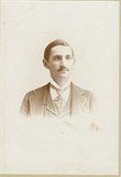
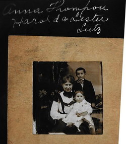
| Description | : | Lester was born on a farm about a mile south of Papillion on September 1, 1904. In 1906 his father bought a 75-barrel flour mill at Dunlap, Iowa, so the family moved to Dunlap. His mother went to Rochester, Minnesota where she underwent surgery for cancer, but never rallied from the surgery and died on Sunday morning, May 3rd. His father remarried Anna C. Dennison on June 23, 1909 in Dunlap, and in 1911 the family moved back to the farm south of Papillion. Lester attended Bell School about a mile south of his home. Later attending Papillion... Read More |
frequently asked questions (FAQ):
-
Where is Lester John Lutz's memorial?
Lester John Lutz's memorial is located at: Evergreen Memorial Park Cemetery, Omaha, Douglas County, USA.
-
When did Lester John Lutz death?
Lester John Lutz death on 23 Dec 1993 in El Paso, El Paso County, Texas, USA
-
Where are the coordinates of the Lester John Lutz's memorial?
Latitude: 41.2393990
Longitude: -96.0355988
Family Members:
Parent
Spouse

Siblings
Children
Flowers:


Nearby Cemetories:
1. Evergreen Memorial Park Cemetery
Omaha, Douglas County, USA
Coordinate: 41.2393990, -96.0355988
2. Resurrection Cemetery
Omaha, Douglas County, USA
Coordinate: 41.2344208, -96.0365448
3. Calvary Cemetery
Omaha, Douglas County, USA
Coordinate: 41.2364006, -96.0294037
4. Saint Andrews Episcopal Church Columbarium
Omaha, Douglas County, USA
Coordinate: 41.2492500, -96.0427500
5. Countryside Community Church Columbarium
Omaha, Douglas County, USA
Coordinate: 41.2483660, -96.0500270
6. Ak-Sar-Ben Racetrack Grounds
Omaha, Douglas County, USA
Coordinate: 41.2414703, -96.0159607
7. Beth El Cemetery
Ralston, Douglas County, USA
Coordinate: 41.2117004, -96.0428009
8. Westlawn-Hillcrest Memorial Park
Omaha, Douglas County, USA
Coordinate: 41.2346992, -95.9966965
9. Bohemian Cemetery
Omaha, Douglas County, USA
Coordinate: 41.2388992, -95.9955978
10. Holy Sepulchre Cemetery
Omaha, Douglas County, USA
Coordinate: 41.2543983, -95.9875031
11. All Saints Episcopal Church Columbarium
Omaha, Douglas County, USA
Coordinate: 41.2785000, -96.0579000
12. Douglas County Poor Farm Cemetery
Omaha, Douglas County, USA
Coordinate: 41.2437240, -95.9723480
13. Graceland Park Cemetery
Omaha, Douglas County, USA
Coordinate: 41.2113991, -95.9785995
14. Saint Mary Magdalene Cemetery
Omaha, Douglas County, USA
Coordinate: 41.2039420, -95.9850610
15. Nash Chapel Crypt
Omaha, Douglas County, USA
Coordinate: 41.2665090, -95.9721790
16. First Central Congregational Columbarium
Omaha, Douglas County, USA
Coordinate: 41.2563456, -95.9658365
17. Servants of Mary Cemetery
Omaha, Douglas County, USA
Coordinate: 41.3017170, -96.0258260
18. Papillion Cemetery
Papillion, Sarpy County, USA
Coordinate: 41.1758003, -96.0410995
19. Saint Mary's Cemetery
Omaha, Douglas County, USA
Coordinate: 41.2042007, -95.9646988
20. Mount Hope Cemetery
Omaha, Douglas County, USA
Coordinate: 41.3041992, -96.0310974
21. Portal Cemetery
Sarpy County, USA
Coordinate: 41.1838989, -96.0802994
22. Pleasant Hill Cemetery
Omaha, Douglas County, USA
Coordinate: 41.2558975, -96.1194687
23. Prospect Hill Cemetery
Omaha, Douglas County, USA
Coordinate: 41.2780991, -95.9593964
24. Mount Sinai Cemetery
Omaha, Douglas County, USA
Coordinate: 41.3116989, -96.0314026