
Lester Schroeder
| Birth | : | 17 Jul 1923 Kingman, Kingman County, Kansas, USA |
| Death | : | 15 Aug 2018 Sioux Falls, Minnehaha County, South Dakota, USA |
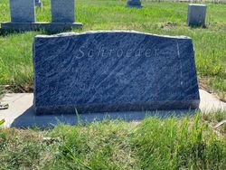
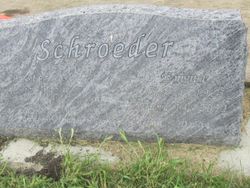
| Burial | : | Tieszen Cemetery, Marion, Turner County, USA |
| Coordinate | : | 43.4219017, -97.3388977 |
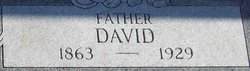
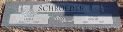
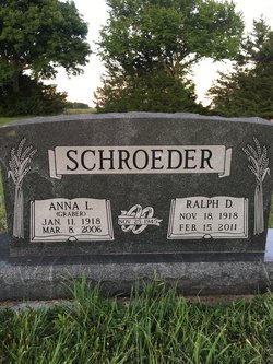
| Description | : | Lester Schroeder, 95, of Sioux Falls passed away on Aug. 15th at Sanford hospital. Lester David Schroeder was welcomed into the family of Emma (Flickner) and David Schroeder in Kingman, Kansas on July 17, 1923. Their family consisted of Raymond (deceased), Hulda (deceased), Ralph (deceased), Viola (deceased), Esther (deceased) and Phoebe (deceased). Lester had many wonderful stories of growing up on a farm with his large family. He attended school in the Kingman area and graduated from Belmont High School. Lester met Emma Becker while on a corn picking crew traveling through South Dakota. They exchanged marriage... Read More |
frequently asked questions (FAQ):
-
Where is Lester Schroeder's memorial?
Lester Schroeder's memorial is located at: Tieszen Cemetery, Marion, Turner County, USA.
-
When did Lester Schroeder death?
Lester Schroeder death on 15 Aug 2018 in Sioux Falls, Minnehaha County, South Dakota, USA
-
Where are the coordinates of the Lester Schroeder's memorial?
Latitude: 43.4219017
Longitude: -97.3388977
Family Members:
Parent
Spouse
Siblings

Flowers:


Nearby Cemetories:
1. Tieszen Cemetery
Marion, Turner County, USA
Coordinate: 43.4219017, -97.3388977
2. Dick Cemetery
Turner County, USA
Coordinate: 43.4528008, -97.3319016
3. Mennonite Cemetery
Dolton, Turner County, USA
Coordinate: 43.4472008, -97.3788986
4. Buller-Ensz Cemetery
Turner County, USA
Coordinate: 43.4186000, -97.2828500
5. West Vermillion Cemetery
Marion, Turner County, USA
Coordinate: 43.4706001, -97.3189011
6. First Church of God Cemetery
Marion, Turner County, USA
Coordinate: 43.4447000, -97.2727000
7. Anna Koerner Burial Site
Hutchinson County, USA
Coordinate: 43.4290258, -97.4196065
8. Saint Marys Catholic Cemetery
Marion, Turner County, USA
Coordinate: 43.4371986, -97.2596970
9. Greenwood Cemetery
Marion, Turner County, USA
Coordinate: 43.4150009, -97.2493973
10. Tschetter Cemetery
Freeman, Hutchinson County, USA
Coordinate: 43.3866997, -97.4197006
11. Our Lady of Lourdes Catholic Cemetery
Dolton, Turner County, USA
Coordinate: 43.4871320, -97.3732960
12. Salem Zion Mennonite Cemetery
Turner County, USA
Coordinate: 43.3507996, -97.3296967
13. Adrian Cemetery
Freeman, Hutchinson County, USA
Coordinate: 43.4730320, -97.4196550
14. Hutterthal Mennonite Church Cemetery
Freeman, Hutchinson County, USA
Coordinate: 43.4041400, -97.4605000
15. Rose Hill Cemetery
McCook County, USA
Coordinate: 43.5119019, -97.3478012
16. Salem Mennonite Church Cemetery
Turner County, USA
Coordinate: 43.3141890, -97.3364110
17. Monroe Reformed Church Cemetery
McCook County, USA
Coordinate: 43.5004100, -97.2358170
18. Turkey Valley Cemetery
Parker, Turner County, USA
Coordinate: 43.3280600, -97.2505500
19. Riverside Cemetery
Canistota, McCook County, USA
Coordinate: 43.5360985, -97.3283005
20. Freeman Cemetery
Freeman, Hutchinson County, USA
Coordinate: 43.3432999, -97.4589005
21. Kleinkassel Cemetery
Hutchinson County, USA
Coordinate: 43.4369011, -97.4997025
22. Spring Valley Baptist Cemetery
Spring Valley Township, McCook County, USA
Coordinate: 43.5325920, -97.2290730
23. Saint Christina Cemetery
Parker, Turner County, USA
Coordinate: 43.3903008, -97.1502991
24. West Side Cemetery
Turner County, USA
Coordinate: 43.2849998, -97.2891998