
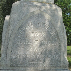
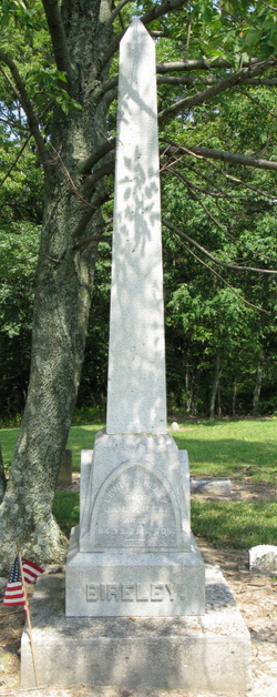
Lewis Bireley
| Birth | : | 2 Oct 1803 Shippensburg, Cumberland County, Pennsylvania, USA |
| Death | : | 7 Jan 1888 |
| Burial | : | Cranbrook Old General Cemetery, Cranbrook, East Kootenay Regional District, Canada |
| Coordinate | : | 49.5116630, -115.7826420 |
| Inscription | : | aged 84y |
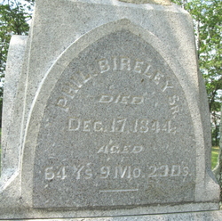
| Description | : | LEWIS BIRELY, retired farmer; P. 0. Catawba. He is a son of Philip and grand-son of Lewis, who was a native of Germany; came to America and located in Lancas-ter Co., Penn., in the year 1730; he served in the Revolutionary war. Philip was born Feb. 24, 1780, in Franklin Co., Penn.; came to Ohio and landed in Springfield Oct. 28, 1839. In February, 1840, he moved upon the farm owned now by the subject of this sketch, and lived there until his death, which occurred Dec. 17. 1844. Lewis was born Oct. 2, 1803, in Shippensburg, Cumberland Co., Penn.;... Read More |
frequently asked questions (FAQ):
-
Where is Lewis Bireley's memorial?
Lewis Bireley's memorial is located at: Cranbrook Old General Cemetery, Cranbrook, East Kootenay Regional District, Canada.
-
When did Lewis Bireley death?
Lewis Bireley death on 7 Jan 1888 in
-
Where are the coordinates of the Lewis Bireley's memorial?
Latitude: 49.5116630
Longitude: -115.7826420
Family Members:
Parent

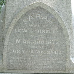
Spouse
Children
Flowers:


Nearby Cemetories:
1. Cranbrook Old General Cemetery
Cranbrook, East Kootenay Regional District, Canada
Coordinate: 49.5116630, -115.7826420
2. Westlawn Cemetery
Cranbrook, East Kootenay Regional District, Canada
Coordinate: 49.5112220, -115.7821910
3. Cranbrook New General Cemetery
Cranbrook, East Kootenay Regional District, Canada
Coordinate: 49.5118890, -115.7837250
4. Cranbrook Catholic Cemetery
Cranbrook, East Kootenay Regional District, Canada
Coordinate: 49.5114080, -115.7813930
5. Aqam Cemetery
Cranbrook, East Kootenay Regional District, Canada
Coordinate: 49.5833840, -115.7574800
6. Fort Steele Cemetery
Fort Steele, East Kootenay Regional District, Canada
Coordinate: 49.6260109, -115.6225662
7. Marysville Cemetery
Marysville, East Kootenay Regional District, Canada
Coordinate: 49.6386900, -115.9513300
8. Kimberley Cemetery
Kimberley, East Kootenay Regional District, Canada
Coordinate: 49.6766700, -115.9746000
9. Moyie Cemetery
Moyie, East Kootenay Regional District, Canada
Coordinate: 49.2743920, -115.8350350
10. Sand Creek Cemetery
Jaffray, East Kootenay Regional District, Canada
Coordinate: 49.3362250, -115.2909390
11. Baynes Lake Cemetery
Baynes Lake, East Kootenay Regional District, Canada
Coordinate: 49.2369900, -115.2106000
12. Yahk Cemetery
Yahk, Central Kootenay Regional District, Canada
Coordinate: 49.0885510, -116.0776230
13. Fernie Cemetery
Fernie, East Kootenay Regional District, Canada
Coordinate: 49.5002240, -115.0579050
14. East Fernie Cemetery
Fernie, East Kootenay Regional District, Canada
Coordinate: 49.5018590, -115.0566640
15. Elko Cemetery
Elko, East Kootenay Regional District, Canada
Coordinate: 49.2978200, -115.1353500
16. Saint Margaret's Cemetery
Fernie, East Kootenay Regional District, Canada
Coordinate: 49.4989900, -115.0550900
17. Morrissey Cemetery
Morrissey, East Kootenay Regional District, Canada
Coordinate: 49.3751030, -114.9941990
18. Hannah Robinson Gravesite
Morrissey, East Kootenay Regional District, Canada
Coordinate: 49.3725000, -114.9913800
19. Hosmer Cemetery
Hosmer, East Kootenay Regional District, Canada
Coordinate: 49.5863580, -114.9565980
20. Goat River Cemetery
Creston, Central Kootenay Regional District, Canada
Coordinate: 49.1411200, -116.3992060
21. Boyd Cemetery
Libby, Lincoln County, USA
Coordinate: 48.9543991, -115.6046982
22. Forest Lawn Cemetery
Creston, Central Kootenay Regional District, Canada
Coordinate: 49.0991400, -116.4626400
23. Rivercrest Cemetery
Sparwood, East Kootenay Regional District, Canada
Coordinate: 49.7617300, -114.8862200
24. Pioneer Cemetery
Creston, Central Kootenay Regional District, Canada
Coordinate: 49.0921800, -116.5127700