

Lewis G Harrach
| Birth | : | 20 Jun 1889 Syracuse, Otoe County, Nebraska, USA |
| Death | : | 14 Jun 1979 Sterling, Logan County, Colorado, USA |
| Burial | : | Kelvin Grove Cemetery, Palmerston North, Palmerston North City, New Zealand |
| Coordinate | : | -40.3239060, 175.6616870 |
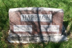
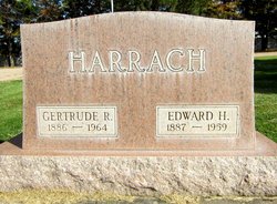
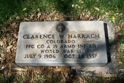
| Description | : | Elvera Lind Harrach and Lewis Harrach were moved from Sunset Gardens to Riverside Cemetery in Sterling about 2 yrs ago. My mother in law, a Harrach by birth and wife of George chose to do this because of the deteriorating conditions at Sunset Gardens. |
frequently asked questions (FAQ):
-
Where is Lewis G Harrach's memorial?
Lewis G Harrach's memorial is located at: Kelvin Grove Cemetery, Palmerston North, Palmerston North City, New Zealand.
-
When did Lewis G Harrach death?
Lewis G Harrach death on 14 Jun 1979 in Sterling, Logan County, Colorado, USA
-
Where are the coordinates of the Lewis G Harrach's memorial?
Latitude: -40.3239060
Longitude: 175.6616870
Family Members:
Parent
Spouse
Siblings
Children

Flowers:


Nearby Cemetories:
1. Kelvin Grove Cemetery
Palmerston North, Palmerston North City, New Zealand
Coordinate: -40.3239060, 175.6616870
2. Terrace End Cemetery
Palmerston North, Palmerston North City, New Zealand
Coordinate: -40.3427170, 175.6433160
3. St Peter's Anglican Church
Roslyn, Palmerston North City, New Zealand
Coordinate: -40.3468897, 175.6279770
4. Bunnythorpe Cemetery
Palmerston North, Palmerston North City, New Zealand
Coordinate: -40.2867770, 175.6272590
5. All Saint's Anglican Church
Palmerston North, Palmerston North City, New Zealand
Coordinate: -40.3581590, 175.6107926
6. Ashhurst Cemetery
Ashhurst, Palmerston North City, New Zealand
Coordinate: -40.3013600, 175.7576040
7. Aorangi Urupā
Manawatu District, New Zealand
Coordinate: -40.2443660, 175.5870110
8. Calleson Family Cemetery
Palmerston North, Palmerston North City, New Zealand
Coordinate: -40.3814600, 175.5157840
9. Old Gorge Cemetery
Woodville, Tararua District, New Zealand
Coordinate: -40.3361206, 175.8332520
10. RSA Woodville Cemetery
Woodville, Tararua District, New Zealand
Coordinate: -40.3362310, 175.8345210
11. Maunga Tauari Urupa
Awahuri, Manawatu District, New Zealand
Coordinate: -40.2619750, 175.5081430
12. Mangahao Cemetery
Ballance, Tararua District, New Zealand
Coordinate: -40.4276820, 175.7890440
13. Feilding Cemetery
Feilding, Manawatu District, New Zealand
Coordinate: -40.1892990, 175.5543140
14. Rongotea Cemetery
Rongotea, Manawatu District, New Zealand
Coordinate: -40.3026690, 175.4526040
15. Lawn Woodville Cemetery
Woodville, Tararua District, New Zealand
Coordinate: -40.3390540, 175.8807710
16. Mangatainoka Cemetery
Pahiatua, Tararua District, New Zealand
Coordinate: -40.4250620, 175.8597850
17. Pohangina Cemetery
Pohangina, Manawatu District, New Zealand
Coordinate: -40.1682490, 175.7946660
18. Sandon Cemetery
Sanson, Manawatu District, New Zealand
Coordinate: -40.2026230, 175.4451310
19. Halcombe Cemetery
Halcombe, Manawatu District, New Zealand
Coordinate: -40.1584590, 175.5019780
20. St Agnes Anglican Churchyard
Kiwitea, Manawatu District, New Zealand
Coordinate: -40.1058087, 175.7196222
21. St Michael & All Angels Churchyard Stanway
Halcombe, Manawatu District, New Zealand
Coordinate: -40.1037600, 175.5814900
22. Bulls Māori Cemetery
Bulls, Rangitikei District, New Zealand
Coordinate: -40.1841400, 175.4092600
23. Kaitawa Cemetery
Kaitawa, Tararua District, New Zealand
Coordinate: -40.4939310, 175.8824710
24. Clifton Cemetery
Bulls, Rangitikei District, New Zealand
Coordinate: -40.1752170, 175.4002900