
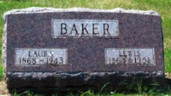
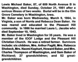

Lewis Michael Baker
| Birth | : | 9 Mar 1864 Virginia, USA |
| Death | : | 21 Oct 1951 Washington County, Iowa, USA |
| Burial | : | Saint Mary Magdalene Cemetery, Omaha, Douglas County, USA |
| Coordinate | : | 41.2039420, -95.9850610 |
| Plot | : | Division C, Block 2 |
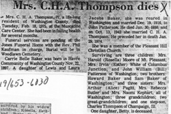
| Description | : | The birth state of Virginia is as reported in the 1900 U.S. Census and his obituary. Birth place in Virginia not determined. Lewis was a son of Norris Baker & Rebecca Dean. Lewis married Laura Letitia Jacobs (1867-1943) on November 11, 1886 in Washington County, Iowa. They had six identified children. |
frequently asked questions (FAQ):
-
Where is Lewis Michael Baker's memorial?
Lewis Michael Baker's memorial is located at: Saint Mary Magdalene Cemetery, Omaha, Douglas County, USA.
-
When did Lewis Michael Baker death?
Lewis Michael Baker death on 21 Oct 1951 in Washington County, Iowa, USA
-
Where are the coordinates of the Lewis Michael Baker's memorial?
Latitude: 41.2039420
Longitude: -95.9850610
Family Members:
Parent
Spouse

Children
Flowers:


Nearby Cemetories:
1. Saint Mary Magdalene Cemetery
Omaha, Douglas County, USA
Coordinate: 41.2039420, -95.9850610
2. Graceland Park Cemetery
Omaha, Douglas County, USA
Coordinate: 41.2113991, -95.9785995
3. Saint Mary's Cemetery
Omaha, Douglas County, USA
Coordinate: 41.2042007, -95.9646988
4. Saint Johns Cemetery
Bellevue, Sarpy County, USA
Coordinate: 41.1864014, -95.9682999
5. Fisher Farm Cemetery
Bellevue, Sarpy County, USA
Coordinate: 41.1727982, -95.9760971
6. Hrabik Cemetery
Bellevue, Sarpy County, USA
Coordinate: 41.1726540, -95.9768200
7. Westlawn-Hillcrest Memorial Park
Omaha, Douglas County, USA
Coordinate: 41.2346992, -95.9966965
8. Laurel Hill Cemetery
Omaha, Douglas County, USA
Coordinate: 41.1918983, -95.9417038
9. Bohemian Cemetery
Omaha, Douglas County, USA
Coordinate: 41.2388992, -95.9955978
10. Douglas County Poor Farm Cemetery
Omaha, Douglas County, USA
Coordinate: 41.2437240, -95.9723480
11. Beth El Cemetery
Ralston, Douglas County, USA
Coordinate: 41.2117004, -96.0428009
12. Ak-Sar-Ben Racetrack Grounds
Omaha, Douglas County, USA
Coordinate: 41.2414703, -96.0159607
13. Calvary Cemetery
Omaha, Douglas County, USA
Coordinate: 41.2364006, -96.0294037
14. Resurrection Cemetery
Omaha, Douglas County, USA
Coordinate: 41.2344208, -96.0365448
15. Holy Sepulchre Cemetery
Omaha, Douglas County, USA
Coordinate: 41.2543983, -95.9875031
16. Papillion Cemetery
Papillion, Sarpy County, USA
Coordinate: 41.1758003, -96.0410995
17. Evergreen Memorial Park Cemetery
Omaha, Douglas County, USA
Coordinate: 41.2393990, -96.0355988
18. First Central Congregational Columbarium
Omaha, Douglas County, USA
Coordinate: 41.2563456, -95.9658365
19. Saint Andrews Episcopal Church Columbarium
Omaha, Douglas County, USA
Coordinate: 41.2492500, -96.0427500
20. Nash Chapel Crypt
Omaha, Douglas County, USA
Coordinate: 41.2665090, -95.9721790
21. Immanuel Lutheran Church Columbarium
Bellevue, Sarpy County, USA
Coordinate: 41.1602700, -95.9218900
22. Countryside Community Church Columbarium
Omaha, Douglas County, USA
Coordinate: 41.2483660, -96.0500270
23. Trinity Cathedral Columbarium
Omaha, Douglas County, USA
Coordinate: 41.2603900, -95.9393660
24. Cedar Dale Cemetery
Papillion, Sarpy County, USA
Coordinate: 41.1418304, -96.0338745