
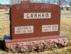
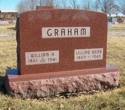
Lillian Webb Graham
| Birth | : | 1869 Baxter, Jasper County, Iowa, USA |
| Death | : | Oct 1949 Des Moines, Polk County, Iowa, USA |
| Burial | : | Saint Peter's Churchyard, Wallingford, South Oxfordshire District, England |
| Coordinate | : | 51.6005819, -1.1215970 |
| Plot | : | Sec/Lot 02-014/Plot C |
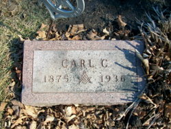
| Description | : | Researched and compiled by the Kartchner Brothers A Descendant of the Kartchner/Wilcox family of Philadelphia Lillian Graham Rites Thursday Services for Mrs. Lillian Webb Graham, 79. of 729 Twenty-seventh st., will be at 9:30 a.m.Thursday at Dunn's funeral home at Baxter. Mrs. Graham lived in Des Moines 10 years. Prior to that she lived in Baxter, where she was born and Union City, Tenn. She was a member of the First Methodist church and the Royal Neighbors of America. Surviving are a daughter. Mrs. F.F. Kallenberg of Des Moines; a son, H.W.... Read More |
frequently asked questions (FAQ):
-
Where is Lillian Webb Graham's memorial?
Lillian Webb Graham's memorial is located at: Saint Peter's Churchyard, Wallingford, South Oxfordshire District, England.
-
When did Lillian Webb Graham death?
Lillian Webb Graham death on Oct 1949 in Des Moines, Polk County, Iowa, USA
-
Where are the coordinates of the Lillian Webb Graham's memorial?
Latitude: 51.6005819
Longitude: -1.1215970
Family Members:
Parent
Spouse
Siblings

Children
Flowers:


Nearby Cemetories:
1. Saint Peter's Churchyard
Wallingford, South Oxfordshire District, England
Coordinate: 51.6005819, -1.1215970
2. All Hallows Graveyard
Wallingford, South Oxfordshire District, England
Coordinate: 51.6020520, -1.1242267
3. St. Mary-le-More Churchyard
Wallingford, South Oxfordshire District, England
Coordinate: 51.5993878, -1.1249488
4. St. Leonard's Churchyard
Wallingford, South Oxfordshire District, England
Coordinate: 51.5972711, -1.1230712
5. St Mary Magdalene Churchyard
Crowmarsh Gifford, South Oxfordshire District, England
Coordinate: 51.5992169, -1.1139564
6. Wallingford Cemetery
Wallingford, South Oxfordshire District, England
Coordinate: 51.6058200, -1.1232000
7. St. John the Baptist Church (Defunct)
Mongwell, South Oxfordshire District, England
Coordinate: 51.5860980, -1.1233580
8. St. Helen's Churchyard
Benson, South Oxfordshire District, England
Coordinate: 51.6200200, -1.1127400
9. St. Helen Churchyard Extension
Benson, South Oxfordshire District, England
Coordinate: 51.6201400, -1.1121200
10. Benson War Memorial
Benson, South Oxfordshire District, England
Coordinate: 51.6207890, -1.1108700
11. Saint James Churchyard
Brightwell cum Sotwell, South Oxfordshire District, England
Coordinate: 51.6120200, -1.1549800
12. St. Mary's Churchyard
North Stoke, South Oxfordshire District, England
Coordinate: 51.5714910, -1.1228080
13. St. Agatha New Churchyard
Brightwell cum Sotwell, South Oxfordshire District, England
Coordinate: 51.6131480, -1.1665480
14. St. Mary's Churchyard
Cholsey, South Oxfordshire District, England
Coordinate: 51.5788078, -1.1589500
15. St. Mary the Virgin Churchyard
Ewelme, South Oxfordshire District, England
Coordinate: 51.6177310, -1.0674850
16. Friends Burying Ground
Warborough, South Oxfordshire District, England
Coordinate: 51.6374080, -1.1354510
17. St Laurence Churchyard
Warborough, South Oxfordshire District, England
Coordinate: 51.6383330, -1.1358310
18. St. Mary the Virgin Cemetery
Ipsden, South Oxfordshire District, England
Coordinate: 51.5674164, -1.0866686
19. All Saints Churchyard
North Moreton, South Oxfordshire District, England
Coordinate: 51.6021922, -1.1898247
20. St. John the Baptist South Moreton
South Moreton, South Oxfordshire District, England
Coordinate: 51.5881630, -1.1895850
21. South Moreton Strict Baptist Chapel
South Moreton, South Oxfordshire District, England
Coordinate: 51.5900300, -1.1924310
22. Saint Birinus Catholic Churchyard
Dorchester, South Oxfordshire District, England
Coordinate: 51.6412600, -1.1649100
23. St John the Baptist
Moulsford, South Oxfordshire District, England
Coordinate: 51.5531050, -1.1482640
24. Dorchester Abbey
Dorchester, South Oxfordshire District, England
Coordinate: 51.6436250, -1.1644290