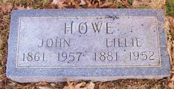
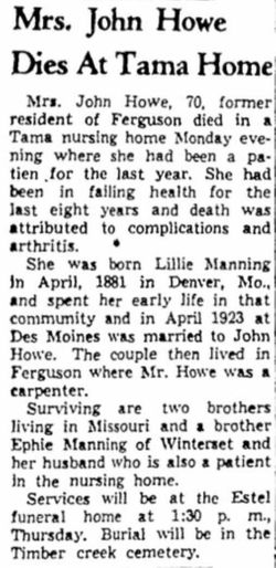
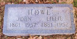
Lillie Adell Manning Howe
| Birth | : | 14 Apr 1881 Denver, Worth County, Missouri, USA |
| Death | : | 21 Jan 1952 Tama, Tama County, Iowa, USA |
| Burial | : | Saint James Lutheran Church Cemetery, Ringgold, Jefferson County, USA |
| Coordinate | : | 40.9864655, -79.1800613 |
frequently asked questions (FAQ):
-
Where is Lillie Adell Manning Howe's memorial?
Lillie Adell Manning Howe's memorial is located at: Saint James Lutheran Church Cemetery, Ringgold, Jefferson County, USA.
-
When did Lillie Adell Manning Howe death?
Lillie Adell Manning Howe death on 21 Jan 1952 in Tama, Tama County, Iowa, USA
-
Where are the coordinates of the Lillie Adell Manning Howe's memorial?
Latitude: 40.9864655
Longitude: -79.1800613
Family Members:
Flowers:
Nearby Cemetories:
1. Saint James Lutheran Church Cemetery
Ringgold, Jefferson County, USA
Coordinate: 40.9864655, -79.1800613
2. Ringgold United Methodist Church Cemetery
Ringgold, Jefferson County, USA
Coordinate: 40.9932137, -79.1680603
3. Shoffner Family Cemetery
Ringgold, Jefferson County, USA
Coordinate: 40.9785050, -79.1498420
4. Dora Evangelical Cemetery
Dora, Jefferson County, USA
Coordinate: 40.9663887, -79.1618576
5. Timblin United Methodist Cemetery
Timblin, Jefferson County, USA
Coordinate: 40.9665620, -79.2057910
6. Mount Tabor Cemetery
Mount Tabor, Armstrong County, USA
Coordinate: 40.9866390, -79.2178760
7. North Freedom United Methodist Church Cemetery
North Freedom, Jefferson County, USA
Coordinate: 41.0229073, -79.2080383
8. Old Ebenezer Cemetery
Jefferson County, USA
Coordinate: 40.9846000, -79.1208600
9. Trinity Reformed Cemetery
Redbank Township, Armstrong County, USA
Coordinate: 41.0224700, -79.2152300
10. Worthville Cemetery
Worthville, Jefferson County, USA
Coordinate: 41.0207062, -79.1404419
11. Saint Johns Reformed UCC Cemetery
Jefferson County, USA
Coordinate: 40.9810000, -79.1180000
12. New Salem Cemetery
Armstrong County, USA
Coordinate: 40.9887733, -79.2424927
13. Minteer-McClatchy Burial Site
Worthville, Jefferson County, USA
Coordinate: 41.0291250, -79.1503140
14. Zion Cemetery
Porter, Jefferson County, USA
Coordinate: 40.9472000, -79.1424800
15. Langville United Methodist Cemetery
Jefferson County, USA
Coordinate: 41.0373000, -79.1763000
16. Copenhaver Crossroads Cemetery
Mc Gregor, Armstrong County, USA
Coordinate: 40.9379463, -79.2207184
17. Fairview Cemetery
Porter, Jefferson County, USA
Coordinate: 40.9260941, -79.1888504
18. Barton Chapel Cemetery
Sprankle Mills, Jefferson County, USA
Coordinate: 41.0026054, -79.0983047
19. Mauk Cemetery
Jefferson County, USA
Coordinate: 41.0241600, -79.1097200
20. Zion Cemetery
Langville, Jefferson County, USA
Coordinate: 41.0539017, -79.1753006
21. Bethlehem Lutheran Cemetery
Ohl, Jefferson County, USA
Coordinate: 41.0583992, -79.1675415
22. Mudlic Cemetery
Charlestown, Armstrong County, USA
Coordinate: 40.9798490, -79.2758420
23. Grange Church of God Cemetery
Grange, Jefferson County, USA
Coordinate: 40.9647170, -79.0876330
24. Saint Jacob Cemetery
Jefferson County, USA
Coordinate: 40.9461900, -79.0987400


