

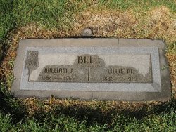
Lillie Mae O'Bryan Bell
| Birth | : | 26 May 1886 Macks Creek, Camden County, Missouri, USA |
| Death | : | 17 Sep 1979 Oxnard, Ventura County, California, USA |
| Burial | : | Conejo Mountain Memorial Park, Camarillo, Ventura County, USA |
| Coordinate | : | 34.1805970, -119.0034930 |
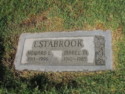
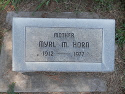
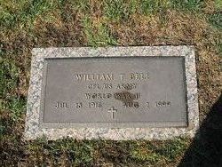
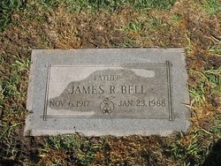
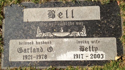
| Description | : | Parents: Alexander Givens O'Bryan & Sarah Elizabeth Whitworth Married: William John Bell Jr on 6 Jun 1907 in Chelsea, Rogers, Oklahoma Their nine children: Ocie Fawn Bell Williams Mabel Mae Bell Estabrook Myrl Margaret Bell Hensley Horn Berna Elizabeth Bell Bernice Fay Bell Hablitzel William Thomas Bell James Robert Bell Garland O'Bryan Bell Donald Eugene Bell Sources: 1. 1900 US Census: Russell, Camden, Missouri 2. 1910 US Census: Armstrong, Nowata, Oklahoma 3. 1920 US Census: Whitebead, Garvin, Oklahoma 4. 1930 US Census: Okemah, Okfuskee, Oklahoma 5. 1940 US Census: Chanute, Neosho, Kansas 6. California, Death Index, 1940-1997 7. Social Security Death Index |
frequently asked questions (FAQ):
-
Where is Lillie Mae O'Bryan Bell's memorial?
Lillie Mae O'Bryan Bell's memorial is located at: Conejo Mountain Memorial Park, Camarillo, Ventura County, USA.
-
When did Lillie Mae O'Bryan Bell death?
Lillie Mae O'Bryan Bell death on 17 Sep 1979 in Oxnard, Ventura County, California, USA
-
Where are the coordinates of the Lillie Mae O'Bryan Bell's memorial?
Latitude: 34.1805970
Longitude: -119.0034930
Family Members:
Parent
Spouse
Siblings
Children
Flowers:


Nearby Cemetories:
1. Camarillo Family Mausoleum
Camarillo, Ventura County, USA
Coordinate: 34.2151690, -119.0361310
2. Pleasant Valley Cemetery
Camarillo, Ventura County, USA
Coordinate: 34.2158480, -119.0373060
3. Saint Columbas Episcopal Church Columbarium
Camarillo, Ventura County, USA
Coordinate: 34.2331850, -119.0554690
4. Olson Family Cemetery
Ventura County, USA
Coordinate: 34.2263300, -118.8688700
5. Masonic Cemetery
Port Hueneme, Ventura County, USA
Coordinate: 34.1622009, -119.1477966
6. Japanese Cemetery
Port Hueneme, Ventura County, USA
Coordinate: 34.1618996, -119.1496964
7. Saint Patricks Episcopal Church Garden
Thousand Oaks, Ventura County, USA
Coordinate: 34.2012360, -118.8492720
8. Saint Paul United Methodist Church Memorial Garden
Oxnard, Ventura County, USA
Coordinate: 34.1815060, -119.1806660
9. In The Shadow Of The Cross Memorial Garden
Oxnard, Ventura County, USA
Coordinate: 34.2158818, -119.1807445
10. Santa Clara Cemetery
Oxnard, Ventura County, USA
Coordinate: 34.2305984, -119.1821976
11. Bard Memorial
Port Hueneme, Ventura County, USA
Coordinate: 34.1565180, -119.1955080
12. Richardson Family Cemetery
Santa Paula, Ventura County, USA
Coordinate: 34.3437350, -119.0463940
13. Ronald Reagan Presidential Library
Simi Valley, Ventura County, USA
Coordinate: 34.2590680, -118.8204260
14. Pierce Brothers Valley Oaks Memorial Park
Westlake Village, Los Angeles County, USA
Coordinate: 34.1528778, -118.7995529
15. Old Russell Cemetery
Ventura County, USA
Coordinate: 34.1518750, -118.7995220
16. Pierce Brothers Santa Paula Cemetery
Santa Paula, Ventura County, USA
Coordinate: 34.3535995, -119.0785980
17. Bardsdale Cemetery
Fillmore, Ventura County, USA
Coordinate: 34.3610992, -118.9403000
18. Church of the Epiphany Episcopal Columbarium
Oak Park, Ventura County, USA
Coordinate: 34.1800880, -118.7754230
19. Ivy Lawn Memorial Park
Ventura, Ventura County, USA
Coordinate: 34.2518997, -119.2153015
20. Irene Hirschi Memorial
Simi Valley, Ventura County, USA
Coordinate: 34.2748010, -118.8015240
21. Assumption Catholic Cemetery
Simi Valley, Ventura County, USA
Coordinate: 34.2570700, -118.7729300
22. Simi Valley Public Cemetery
Simi Valley, Ventura County, USA
Coordinate: 34.2656700, -118.7669300
23. Trinity Lutheran Church Columbarium
Ventura, Ventura County, USA
Coordinate: 34.2772220, -119.2394440
24. Saint Pauls Episcopal Church Memorial Garden
Ventura, Ventura County, USA
Coordinate: 34.2759070, -119.2522820