
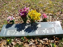
Lillie Marie Hawn Elmore
| Birth | : | 29 Jun 1915 |
| Death | : | 21 Sep 1999 |
| Burial | : | Park View Cemetery, Manteca, San Joaquin County, USA |
| Coordinate | : | 37.8617249, -121.2238312 |
| Description | : | LILLIE MARIE ELMORE Funeral services for Lillie Marie Elmore, 84, of Crossville, who passed away Sept. 21, 1999, were held Sept. 23 from the chapel of Bilbrey Funeral Home, with burial in Elmore Cemetery. The Rev. Frank Walker officiated. She was born June 29, 1915 in Cumberland County, the daughter of Burton and Sarah Potter Hawn. Mrs. Elmore was a homemaker and she was of the Methodist faith. Survivors include her sons, Bill Elmore of Murfreesboro, Chet Elmore and Alva Elmore, both of Crossville, Estel Elmore of Auburndale, FL, and Riley Elmore of Palaka, FL; and daughters, Elsie Beyers of Knoxville, Gladys... Read More |
frequently asked questions (FAQ):
-
Where is Lillie Marie Hawn Elmore's memorial?
Lillie Marie Hawn Elmore's memorial is located at: Park View Cemetery, Manteca, San Joaquin County, USA.
-
When did Lillie Marie Hawn Elmore death?
Lillie Marie Hawn Elmore death on 21 Sep 1999 in
-
Where are the coordinates of the Lillie Marie Hawn Elmore's memorial?
Latitude: 37.8617249
Longitude: -121.2238312
Family Members:
Parent
Spouse

Siblings
Children
Flowers:


Nearby Cemetories:
1. Congregation Adas Yeshuran of Stockton Cemetery
French Camp, San Joaquin County, USA
Coordinate: 37.8784065, -121.2740784
2. Congregation of Ahavas Achim Cemetery
French Camp, San Joaquin County, USA
Coordinate: 37.8778419, -121.2753067
3. Chinese Cemetery
French Camp, San Joaquin County, USA
Coordinate: 37.8819962, -121.2805862
4. East Union Cemetery
Manteca, San Joaquin County, USA
Coordinate: 37.8114014, -121.2350006
5. Atlanta Cemetery
Five Corners, San Joaquin County, USA
Coordinate: 37.8270035, -121.1420135
6. Collegeville Cemetery
Collegeville, San Joaquin County, USA
Coordinate: 37.9044800, -121.1466141
7. Citizens Cemetery
Stockton, San Joaquin County, USA
Coordinate: 37.9559410, -121.2769120
8. Thomas Lindsay Gravesite
San Joaquin County, USA
Coordinate: 37.9573110, -121.2918430
9. David Kelsey Gravesite
Stockton, San Joaquin County, USA
Coordinate: 37.9573110, -121.2918430
10. Temple Israel Cemetery
Stockton, San Joaquin County, USA
Coordinate: 37.9640541, -121.2784348
11. Stockton State Hospital Cemetery
Stockton, San Joaquin County, USA
Coordinate: 37.9663110, -121.2846850
12. San Joaquin Catholic Cemetery
Stockton, San Joaquin County, USA
Coordinate: 37.9707830, -121.2850190
13. Casa Bonita Mausoleum
Stockton, San Joaquin County, USA
Coordinate: 37.9752340, -121.2877800
14. Stockton Woodland Mausoleum
Stockton, San Joaquin County, USA
Coordinate: 37.9762400, -121.2878000
15. Stockton Rural Cemetery
Stockton, San Joaquin County, USA
Coordinate: 37.9794006, -121.2869034
16. Saint John's Catholic Cemetery
Escalon, San Joaquin County, USA
Coordinate: 37.7994537, -121.0705185
17. Central United Methodist Church Columbarium
Stockton, San Joaquin County, USA
Coordinate: 37.9825710, -121.3078170
18. Ripon Cemetery
Ripon, San Joaquin County, USA
Coordinate: 37.7420311, -121.1238708
19. Highland View Memorial Gardens
Farmington, San Joaquin County, USA
Coordinate: 37.9242935, -121.0008621
20. Linden Cemetery
Linden, San Joaquin County, USA
Coordinate: 38.0226707, -121.0889053
21. Tracy Mausoleum
Tracy, San Joaquin County, USA
Coordinate: 37.7250214, -121.4150696
22. Tracy Public Cemetery
Tracy, San Joaquin County, USA
Coordinate: 37.7251358, -121.4189453
23. Wood Colony Cemetery
Salida, Stanislaus County, USA
Coordinate: 37.6893730, -121.0682144
24. Good Shepherd Catholic Cemetery
Modesto, Stanislaus County, USA
Coordinate: 37.6853130, -121.0672890