
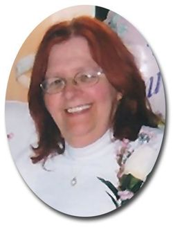
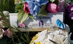
Linda Paulson Simmons
| Birth | : | 7 Jun 1949 New Rockford, Eddy County, North Dakota, USA |
| Death | : | 2 Sep 2019 Minot, Ward County, North Dakota, USA |
| Burial | : | Lansford Cemetery, Lansford, Bottineau County, USA |
| Coordinate | : | 48.6189003, -101.3867035 |
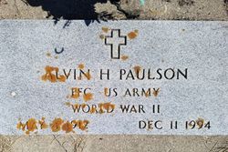
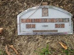
| Description | : | Linda Fay Simmons, 70, Lansford, died Monday, September 2, 2019, at a Minot hospital. She was born June 7, 1949, in New Rockford, a daughter of Alvin and Irene (Baldwin) Paulson. She was raised in Riverdale, and later Pick City, where her dad worked on the construction of the Garrison Dam. Linda graduated from Riverdale High School in 1969. After graduation, she held various jobs. Linda married Christopher “Chris” Simmons on February 2, 1974, at Minot AFB. They lived in Minot where Linda worked various cleaning jobs before her daughter, Christine, was born. In 1977, they made their home in... Read More |
frequently asked questions (FAQ):
-
Where is Linda Paulson Simmons's memorial?
Linda Paulson Simmons's memorial is located at: Lansford Cemetery, Lansford, Bottineau County, USA.
-
When did Linda Paulson Simmons death?
Linda Paulson Simmons death on 2 Sep 2019 in Minot, Ward County, North Dakota, USA
-
Where are the coordinates of the Linda Paulson Simmons's memorial?
Latitude: 48.6189003
Longitude: -101.3867035
Family Members:
Parent
Flowers:


Nearby Cemetories:
1. Lansford Cemetery
Lansford, Bottineau County, USA
Coordinate: 48.6189003, -101.3867035
2. Saint Johns Cemetery
Lansford, Bottineau County, USA
Coordinate: 48.6314011, -101.3961029
3. Shook Cemetery
Renville County, USA
Coordinate: 48.5419273, -101.3651505
4. Renville Cemetery
Renville, Bottineau County, USA
Coordinate: 48.7485900, -101.3220700
5. Grano Cemetery
Grano, Renville County, USA
Coordinate: 48.6136017, -101.6038971
6. Saint Philomena Catholic Cemetery
Glenburn, Renville County, USA
Coordinate: 48.5110168, -101.2291183
7. Fairview Cemetery
Glenburn, Renville County, USA
Coordinate: 48.5099983, -101.2288971
8. Saint Henrys Cemetery
Renville County, USA
Coordinate: 48.4846992, -101.5108032
9. Mohall Cemetery
Cut Bank Township, Bottineau County, USA
Coordinate: 48.7627983, -101.4850006
10. Brotherhood Cemetery
Bottineau County, USA
Coordinate: 48.7780991, -101.4736023
11. Lynch Immanuel Lutheran Church Cemetery
Ward County, USA
Coordinate: 48.4293213, -101.3009720
12. Our Saviors Cemetery
Eckman, Bottineau County, USA
Coordinate: 48.5459500, -101.1025900
13. Graceland Cemetery
Maxbass, Bottineau County, USA
Coordinate: 48.7344017, -101.1363983
14. Riverside Cemetery
Eckman, Bottineau County, USA
Coordinate: 48.6315117, -101.0602493
15. Gethsemane Cemetery
Carpio, Ward County, USA
Coordinate: 48.5747261, -101.7124481
16. Bethany Lutheran Cemetery
Minot, Ward County, USA
Coordinate: 48.4294000, -101.2133000
17. Nazareth Lutheran Cemetery
Renville County, USA
Coordinate: 48.4733180, -101.6480450
18. Holden Cemetery
Eckman, Bottineau County, USA
Coordinate: 48.6906776, -101.0336533
19. Bethel Lutheran Brethren Cemetery
Antler, Bottineau County, USA
Coordinate: 48.8720245, -101.3008423
20. Nidaros Lutheran Cemetery
Wolseth, Ward County, USA
Coordinate: 48.4438000, -101.0962000
21. Emmanuel Lutheran Cemetery
Ruthville, Ward County, USA
Coordinate: 48.3562851, -101.3823090
22. Wolff Family Cemetery
Ruthville, Ward County, USA
Coordinate: 48.3557300, -101.3768800
23. Hamel Catholic Cemetery
Dunning, Bottineau County, USA
Coordinate: 48.7707930, -101.0599920
24. Des Lacs Valley Cemetery
Carpio, Ward County, USA
Coordinate: 48.4011200, -101.6208900