
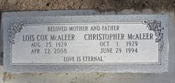
Lois Marie Cox McAleer
| Birth | : | 25 Aug 1929 Gordon, Sheridan County, Nebraska, USA |
| Death | : | 22 Apr 2008 Sacramento County, California, USA |
| Burial | : | Gordon Cemetery, Gordon, Sheridan County, USA |
| Coordinate | : | 42.7858009, -102.2102966 |
frequently asked questions (FAQ):
-
Where is Lois Marie Cox McAleer's memorial?
Lois Marie Cox McAleer's memorial is located at: Gordon Cemetery, Gordon, Sheridan County, USA.
-
When did Lois Marie Cox McAleer death?
Lois Marie Cox McAleer death on 22 Apr 2008 in Sacramento County, California, USA
-
Where are the coordinates of the Lois Marie Cox McAleer's memorial?
Latitude: 42.7858009
Longitude: -102.2102966
Family Members:
Parent
Spouse

Siblings
Flowers:


Nearby Cemetories:
1. Gordon Cemetery
Gordon, Sheridan County, USA
Coordinate: 42.7858009, -102.2102966
2. Mount Hope Cemetery
Gordon, Sheridan County, USA
Coordinate: 42.7113991, -102.2241974
3. Dane Cemetery
Cherry County, USA
Coordinate: 42.7924300, -102.0824700
4. Bethel Cemetery
Sheridan County, USA
Coordinate: 42.9011002, -102.3208008
5. Lavaca Cemetery
Irwin, Cherry County, USA
Coordinate: 42.7332993, -102.0175018
6. Amity Cemetery
Sheridan County, USA
Coordinate: 42.8036003, -102.4389038
7. Fair View Cemetery
Rushville, Sheridan County, USA
Coordinate: 42.7155991, -102.4325027
8. Saint Aloysius Cemetery
Sheridan County, USA
Coordinate: 42.9015500, -102.4025500
9. Saint Marys Cemetery
Rushville, Sheridan County, USA
Coordinate: 42.7174988, -102.4436035
10. Feather on Head Cemetery
Oglala Lakota County, USA
Coordinate: 43.0311012, -102.1611023
11. Holly Cemetery
Rushville, Sheridan County, USA
Coordinate: 42.8575120, -102.5370990
12. Novotny Cemetery
Hay Springs, Sheridan County, USA
Coordinate: 42.7742004, -102.5963974
13. Davis Cemetery
Rushville, Sheridan County, USA
Coordinate: 42.5421000, -102.4118800
14. Wolf Creek Community Cemetery
Oglala Lakota County, USA
Coordinate: 43.0405750, -102.3966490
15. Spotted Bear Family Cemetery
Denby, Oglala Lakota County, USA
Coordinate: 43.0608200, -102.3376600
16. Preble Cemetery
Sheridan County, USA
Coordinate: 42.6504000, -102.5765000
17. Abold Family Cemetery
Rushville, Sheridan County, USA
Coordinate: 42.8863500, -102.6158000
18. Bomar Cemetery
Hay Springs, Sheridan County, USA
Coordinate: 42.8062000, -102.6459600
19. Native American Cemetery
Oglala, Oglala Lakota County, USA
Coordinate: 43.0886002, -102.3550034
20. White Clay Cemetery
Rushville, Sheridan County, USA
Coordinate: 42.9732820, -102.5667230
21. Knight Cemetery
Oglala Lakota County, USA
Coordinate: 43.1039009, -102.1200027
22. Holy Cross Cemetery
Pine Ridge, Oglala Lakota County, USA
Coordinate: 43.0194016, -102.5503006
23. Pine Ridge Presbyterian Cemetery
Pine Ridge, Oglala Lakota County, USA
Coordinate: 43.0235200, -102.5506200
24. Beguin Cemetery
Sheridan County, USA
Coordinate: 42.5107994, -102.4982986