
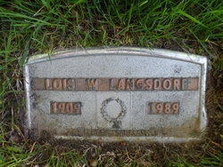
Lois W Boyle Langsdorf
| Birth | : | 8 Feb 1909 Libby, Lincoln County, Montana, USA |
| Death | : | 14 Dec 1989 Sandpoint, Bonner County, Idaho, USA |
| Burial | : | Pinecrest Memorial Park, Sandpoint, Bonner County, USA |
| Coordinate | : | 48.2797203, -116.5869370 |
| Description | : | Newspapers.com Obituary Index, 1800s-current Name: Lois W. Langsdorf Gender: Female Death Age: 80 Birth Date: abt 1909 Birth Place: Libby, Mont. Residence Place: Sandpoint Death Date: Abt 1989 Death Place: Sandpoint Obituary Date: 19 Dec 1989 Obituary Place: Spokane, Washington, USA Newspaper Title: The Spokesman-Review Spouse: Bernard Langsdorf Siblings: Nina Sheer, Mary Hyatt Montana, U.S., County Marriages, 1865-1987 Name: Lois W. Boyle Gender: Female Race: White Age: 28 Birth Date: abt 1909 Birth Place: Libby, Lincoln, Montana Marriage Date: 26 Nov 1937 Marriage Place: Libby, Lincoln, Montana, USA Father: D. P. Boyle Mother: Mildred Boyle Spouse: Bernie H. Langsdorf |
frequently asked questions (FAQ):
-
Where is Lois W Boyle Langsdorf's memorial?
Lois W Boyle Langsdorf's memorial is located at: Pinecrest Memorial Park, Sandpoint, Bonner County, USA.
-
When did Lois W Boyle Langsdorf death?
Lois W Boyle Langsdorf death on 14 Dec 1989 in Sandpoint, Bonner County, Idaho, USA
-
Where are the coordinates of the Lois W Boyle Langsdorf's memorial?
Latitude: 48.2797203
Longitude: -116.5869370
Family Members:
Parent

Spouse
Siblings
Flowers:


Nearby Cemetories:
1. Pinecrest Memorial Park
Sandpoint, Bonner County, USA
Coordinate: 48.2797203, -116.5869370
2. Lakeview Cemetery
Sandpoint, Bonner County, USA
Coordinate: 48.2619019, -116.5661011
3. Colburn Cemetery
Colburn, Bonner County, USA
Coordinate: 48.3918000, -116.5384900
4. Gamlin Lake Cemetery
Sagle, Bonner County, USA
Coordinate: 48.2186127, -116.4194412
5. Pack River Cemetery
Bonner County, USA
Coordinate: 48.3675620, -116.4404120
6. Westmond Cemetery
Westmond, Bonner County, USA
Coordinate: 48.1464005, -116.5986023
7. Drake Cemetery
Bonner County, USA
Coordinate: 48.1180500, -116.5402700
8. Gold Creek Cemetery
Bonner County, USA
Coordinate: 48.4000015, -116.4160995
9. Seneacquoteen Cemetery
Sandpoint, Bonner County, USA
Coordinate: 48.1510000, -116.7592000
10. Old Hope Cemetery
Hope, Bonner County, USA
Coordinate: 48.2530500, -116.3157300
11. Hope Cemetery
East Hope, Bonner County, USA
Coordinate: 48.2449989, -116.2966995
12. Cloudledge Cemetery
East Hope, Bonner County, USA
Coordinate: 48.2345670, -116.2772340
13. Owen Family Cemetery
East Hope, Bonner County, USA
Coordinate: 48.2160100, -116.2790200
14. Evergreen Cemetery
Priest River, Bonner County, USA
Coordinate: 48.1907959, -116.9042740
15. Clara Cemetery
Bonner County, USA
Coordinate: 48.0344009, -116.4486008
16. McArthur Cemetery
Boundary County, USA
Coordinate: 48.5246000, -116.4350000
17. Clark Fork Cemetery
Clark Fork, Bonner County, USA
Coordinate: 48.1610000, -116.1690000
18. Newport Cemetery
Newport, Pend Oreille County, USA
Coordinate: 48.1747017, -117.0669022
19. Mountain View Cemetery
Athol, Kootenai County, USA
Coordinate: 47.9484000, -116.7218500
20. Greenwood Cemetery
Spirit Lake, Kootenai County, USA
Coordinate: 47.9636002, -116.8582993
21. Holy Myrrhbearers Orthodox Church Parish Cemetery
Bonners Ferry, Boundary County, USA
Coordinate: 48.6190260, -116.3598830
22. Blanchard Cemetery
Blanchard, Bonner County, USA
Coordinate: 48.0168991, -116.9805984
23. Spring Valley Mennonite Cemetery
Newport, Pend Oreille County, USA
Coordinate: 48.0859800, -117.0796400
24. Cabinet Cemetery
Bonner County, USA
Coordinate: 48.0826000, -116.0681000