
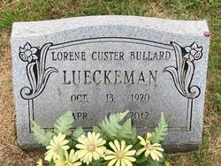

Lorene Mae Bullard Custer Lueckeman
| Birth | : | 13 Oct 1920 Thayer, Oregon County, Missouri, USA |
| Death | : | 6 Apr 2012 Alton, Oregon County, Missouri, USA |
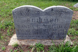
| Burial | : | New Salem Cemetery, Couch, Oregon County, USA |
| Coordinate | : | 36.6042252, -91.3712463 |
| Description | : | Lorene Mae Lueckeman, age 91 of Alton, MO was born October 13, 1920 in Thayer, MO and passed away April 6, 2012 at Shepherds View, Alton, MO. Lorene retired from Citizens Bank, Flint, MI. She was of the Baptist faith Survivors include one son, Ronald Bullard; two step-sons, Donald and Louise Lueckeman; Mark Lueckeman; one step-daughter, Jeanne and Lynn Eastman, all of MI, 15 grandchildren, several great-grandchildren; one brother, Raymond and Laurene Custer of TX, one sister, Beulah Custer of KY, one sister-in-law, Nell Custer of Alton, MO, and numerous other relatives and friends. Preceding her in death... Read More |
frequently asked questions (FAQ):
-
Where is Lorene Mae Bullard Custer Lueckeman's memorial?
Lorene Mae Bullard Custer Lueckeman's memorial is located at: New Salem Cemetery, Couch, Oregon County, USA.
-
When did Lorene Mae Bullard Custer Lueckeman death?
Lorene Mae Bullard Custer Lueckeman death on 6 Apr 2012 in Alton, Oregon County, Missouri, USA
-
Where are the coordinates of the Lorene Mae Bullard Custer Lueckeman's memorial?
Latitude: 36.6042252
Longitude: -91.3712463
Family Members:
Parent

Siblings

Children
Flowers:


Nearby Cemetories:
1. New Salem Cemetery
Couch, Oregon County, USA
Coordinate: 36.6042252, -91.3712463
2. Olon Tucker Farm Cemetery #2
Couch, Oregon County, USA
Coordinate: 36.5867000, -91.3705400
3. Baker Cemetery
Couch, Oregon County, USA
Coordinate: 36.6248283, -91.3932877
4. Garfield Cemetery
Garfield, Oregon County, USA
Coordinate: 36.5844400, -91.3253400
5. Cave Springs Cemetery #2
Alton, Oregon County, USA
Coordinate: 36.6488900, -91.3652900
6. Cave Springs Cemetery
Alton, Oregon County, USA
Coordinate: 36.6492004, -91.3655014
7. Crabb Cemetery
Couch, Oregon County, USA
Coordinate: 36.5988541, -91.4339752
8. Arytown Cemetery
Arytown, Oregon County, USA
Coordinate: 36.5539513, -91.3795776
9. Bonds Cemetery
Couch, Oregon County, USA
Coordinate: 36.5989914, -91.4346619
10. Russell Cemetery
Couch, Oregon County, USA
Coordinate: 36.5506477, -91.3991928
11. Adolph Ostrom Farm Cemetery
Thayer, Oregon County, USA
Coordinate: 36.5788160, -91.4426640
12. Guiteau-Risner Cemetery
Guiteau, Oregon County, USA
Coordinate: 36.5588074, -91.3156128
13. Norman Cemetery
Alton, Oregon County, USA
Coordinate: 36.6143990, -91.4499969
14. John Brown Cemetery
Jobe, Oregon County, USA
Coordinate: 36.5812111, -91.2953568
15. Copenhagen Cemetery
Couch, Oregon County, USA
Coordinate: 36.6347421, -91.4460619
16. Copenhagen Family Cemetery
Alton, Oregon County, USA
Coordinate: 36.6369684, -91.4464551
17. Crass Homestead
Myrtle, Oregon County, USA
Coordinate: 36.5359695, -91.3084671
18. Old Culp Place
Alton, Oregon County, USA
Coordinate: 36.6892400, -91.3760600
19. Lance Cemetery
Many Springs, Oregon County, USA
Coordinate: 36.6310997, -91.2699966
20. Midway Cemetery
Couch, Oregon County, USA
Coordinate: 36.6031690, -91.4788520
21. Cotton Creek Cemetery
Jobe, Oregon County, USA
Coordinate: 36.5844002, -91.2652969
22. Dills Cemetery
Alton, Oregon County, USA
Coordinate: 36.6596985, -91.4586029
23. Alton City Cemetery
Alton, Oregon County, USA
Coordinate: 36.6918983, -91.3982010
24. Many Springs Cemetery
Many Springs, Oregon County, USA
Coordinate: 36.6521200, -91.2695100