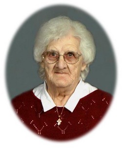
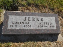
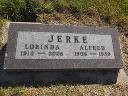
Lorinda Adina Stelzer Jerke
| Birth | : | 23 Nov 1913 |
| Death | : | 15 Sep 2006 Yankton, Yankton County, South Dakota, USA |
| Burial | : | Fernwood Cemetery, Port Elgin, Westmorland County, Canada |
| Coordinate | : | 46.0637300, -64.0908500 |
| Plot | : | Section 9, Lot 14 |
| Description | : | Lorinda Adina Jerke was born on November 23, 1913 to John and Helen (Tiede) Stelzer. She was confirmed on June 24, 1928 at Parkston by Rev. J. Rathenberger. Lorinda was united in marriage to Alfred Jerke on March 2, 1938 at Zion Congregational Church in Parkston. She lived on their farm 2 ½ miles southwest of Kaylor for most of her life. She was a member of Zion Lutheran Church and a past member of Emmanuel Lutheran Church in Kaylor where she sang in the choir for many years. Lorinda was a devoted farm wife and... Read More |
frequently asked questions (FAQ):
-
Where is Lorinda Adina Stelzer Jerke's memorial?
Lorinda Adina Stelzer Jerke's memorial is located at: Fernwood Cemetery, Port Elgin, Westmorland County, Canada.
-
When did Lorinda Adina Stelzer Jerke death?
Lorinda Adina Stelzer Jerke death on 15 Sep 2006 in Yankton, Yankton County, South Dakota, USA
-
Where are the coordinates of the Lorinda Adina Stelzer Jerke's memorial?
Latitude: 46.0637300
Longitude: -64.0908500
Family Members:
Flowers:
Nearby Cemetories:
1. Fernwood Cemetery
Port Elgin, Westmorland County, Canada
Coordinate: 46.0637300, -64.0908500
2. Saint Clement Cemetery
Port Elgin, Westmorland County, Canada
Coordinate: 46.0602220, -64.0894170
3. Saint James Presbyterian Church Cemetery Old
Port Elgin, Westmorland County, Canada
Coordinate: 46.0466900, -64.0889800
4. Fort Gaspareaux
Port Elgin, Westmorland County, Canada
Coordinate: 46.0432400, -64.0706000
5. Baie Verte Cemetery
Baie-Verte, Westmorland County, Canada
Coordinate: 46.0270050, -64.1060830
6. Reade Cemetery
Bayside, Westmorland County, Canada
Coordinate: 46.0574170, -64.0156311
7. Shemogue Cemetery
Shemogue, Westmorland County, Canada
Coordinate: 46.1431443, -64.1464963
8. Tidnish Bridge Cemetery
Tidnish Bridge, Cumberland County, Canada
Coordinate: 45.9797300, -64.0478900
9. Oxley Cemetery
Tidnish Cross Roads, Cumberland County, Canada
Coordinate: 45.9934670, -64.0099350
10. Shemogue Presbyterian Cemetery
Shemogue, Westmorland County, Canada
Coordinate: 46.1484340, -64.1712680
11. Upper Cape Cemetery
Upper Cape, Westmorland County, Canada
Coordinate: 46.0584600, -63.9390600
12. Upper Cape Cross Road Cemetery
Melrose, Westmorland County, Canada
Coordinate: 46.0893370, -63.9430440
13. Saint Timothee Cemetery
Shemogue, Westmorland County, Canada
Coordinate: 46.1547500, -64.1843600
14. Murray Cemetery
Little Shemogue, Westmorland County, Canada
Coordinate: 46.1468786, -63.9711233
15. Anderson Settlement Cemetery
Anderson Settlement, Westmorland County, Canada
Coordinate: 46.1148880, -64.2459160
16. Saint Bartholomew's Cemetery
Melrose, Westmorland County, Canada
Coordinate: 46.1016550, -63.9107330
17. Lorneville Cemetery
Lorneville, Cumberland County, Canada
Coordinate: 45.9841110, -63.9347650
18. Pioneer Cemetery
Murray Corner, Westmorland County, Canada
Coordinate: 46.1782000, -63.9831300
19. Baxter's Cemetery
Lorneville, Cumberland County, Canada
Coordinate: 45.9800083, -63.9213889
20. Pioneer Irish Cemetery
Melrose, Westmorland County, Canada
Coordinate: 46.1093300, -63.8812500
21. Amherst Shore Baptist Cemetery
Amherst Shore, Cumberland County, Canada
Coordinate: 45.9746626, -63.9016351
22. Pioneer Cemetery
Westmorland County, Canada
Coordinate: 45.9359100, -64.2343500
23. Trenholm Cemetery
Spence Settlement, Westmorland County, Canada
Coordinate: 46.1423770, -63.8858410
24. Upper Pointe de Bute Baptist Cemetery
Point de Bute, Westmorland County, Canada
Coordinate: 45.9249300, -64.2197200


