
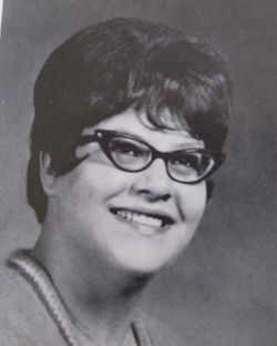
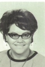
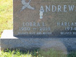
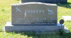
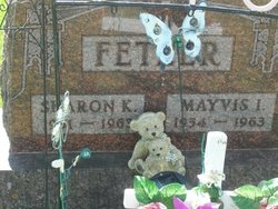
Lorra Lee Fetzer Andrews
| Birth | : | 15 Apr 1950 |
| Death | : | 16 Oct 2013 Bismarck, Burleigh County, North Dakota, USA |
| Burial | : | Garrison Cemetery, Garrison, McLean County, USA |
| Coordinate | : | 47.6650000, -101.4201000 |
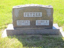
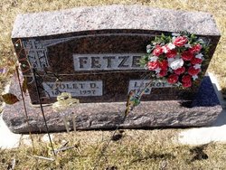
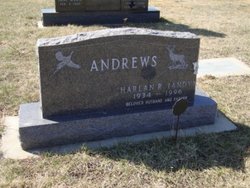
| Description | : | Lorra Andrews, 63, Garrison, died on Wednesday, October 16, 2013, at a Bismarck hospital. Funeral services will be held on Saturday at 2:00 pm at the First Congregational Church in Garrison. Burial will be at the Garrison City Cemetery. Lorra Lee (Fetzer) Andrews was born April 15, 1950. She was the first of six daughters to LeeRoy and Violet (Hintz) Fetzer. She graduated from Garrison High School in 1968 and went on to become a beautician. On April 15, 1977 she married Harlan Ray Andrews. After they were married they made their home in rural Garrison ND. Their son Jeremy... Read More |
frequently asked questions (FAQ):
-
Where is Lorra Lee Fetzer Andrews's memorial?
Lorra Lee Fetzer Andrews's memorial is located at: Garrison Cemetery, Garrison, McLean County, USA.
-
When did Lorra Lee Fetzer Andrews death?
Lorra Lee Fetzer Andrews death on 16 Oct 2013 in Bismarck, Burleigh County, North Dakota, USA
-
Where are the coordinates of the Lorra Lee Fetzer Andrews's memorial?
Latitude: 47.6650000
Longitude: -101.4201000
Family Members:
Parent
Spouse
Siblings
Flowers:


Nearby Cemetories:
1. Garrison Cemetery
Garrison, McLean County, USA
Coordinate: 47.6650000, -101.4201000
2. Saint Nicholas Cemetery
Garrison, McLean County, USA
Coordinate: 47.6469210, -101.3976590
3. Kloestitz German Cemetery
McLean County, USA
Coordinate: 47.6739490, -101.3461250
4. Saint Pauls Cemetery
Garrison, McLean County, USA
Coordinate: 47.6570200, -101.3344940
5. Fort Stevenson Post Cemetery
McLean County, USA
Coordinate: 47.5758800, -101.4453500
6. Saint Pauls Lutheran Cemetery
Douglas Township, McLean County, USA
Coordinate: 47.7476349, -101.4856491
7. Endres Catholic Cemetery
Max, McLean County, USA
Coordinate: 47.7099075, -101.2397003
8. Zion Lutheran Cemetery
Max, McLean County, USA
Coordinate: 47.7653999, -101.2937622
9. Clifton Cemetery
McLean County, USA
Coordinate: 47.7317009, -101.6235962
10. Saint Peter Cemetery
Emmet, McLean County, USA
Coordinate: 47.6742020, -101.6510010
11. Geminde Cemetery
Mercer County, USA
Coordinate: 47.5172005, -101.5061035
12. Saint Johns Congregational Cemetery
Max, McLean County, USA
Coordinate: 47.6871730, -101.1750700
13. Max City Cemetery
Max, McLean County, USA
Coordinate: 47.8127100, -101.2935300
14. Miller Cemetery
Pick City, Mercer County, USA
Coordinate: 47.5018480, -101.5100250
15. Max City Cemetery Old
Max, McLean County, USA
Coordinate: 47.8268088, -101.3014727
16. Evangelical Lutheran Cemetery
Max, McLean County, USA
Coordinate: 47.8268000, -101.3000000
17. Saint Mathew Cemetery
Max, McLean County, USA
Coordinate: 47.7755740, -101.1972780
18. Trinity Mannhaven Cemetery
Pick City, Mercer County, USA
Coordinate: 47.4880260, -101.5064950
19. Immaculate Conception Cemetery
Max, McLean County, USA
Coordinate: 47.8177986, -101.2613983
20. Lilly Dale Cemetery
Emmet, McLean County, USA
Coordinate: 47.5887050, -101.6742500
21. First German Baptist Cemetery
Max, McLean County, USA
Coordinate: 47.6887283, -101.1341629
22. First Baptist Cemetery
Ward County, USA
Coordinate: 47.8484612, -101.2989349
23. Douglas City Cemetery
Douglas, Ward County, USA
Coordinate: 47.8610600, -101.4975100
24. Coleharbor Cemetery
Coleharbor, McLean County, USA
Coordinate: 47.5024986, -101.2369003