
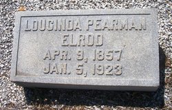

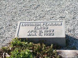
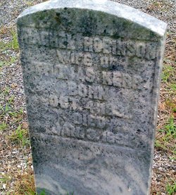
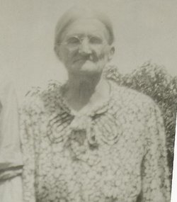
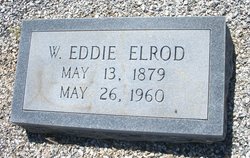
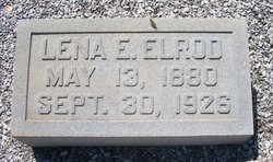
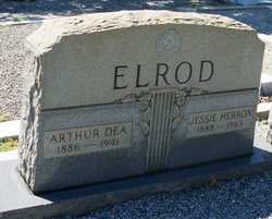
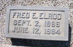
Loucinda Pearman Elrod
| Birth | : | 9 Apr 1857 |
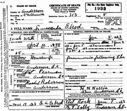
| Death | : | 5 Jan 1923 |
| Burial | : | Barton Wesleyan Methodist Chapelyard, Eccles, Metropolitan Borough of Salford, England |
| Coordinate | : | 53.4763680, -2.3559280 |
frequently asked questions (FAQ):
-
Where is Loucinda Pearman Elrod's memorial?
Loucinda Pearman Elrod's memorial is located at: Barton Wesleyan Methodist Chapelyard, Eccles, Metropolitan Borough of Salford, England.
-
When did Loucinda Pearman Elrod death?
Loucinda Pearman Elrod death on 5 Jan 1923 in
-
Where are the coordinates of the Loucinda Pearman Elrod's memorial?
Latitude: 53.4763680
Longitude: -2.3559280
Family Members:
Parent

Spouse
Siblings
Children


Nearby Cemetories:
1. Barton Wesleyan Methodist Chapelyard
Eccles, Metropolitan Borough of Salford, England
Coordinate: 53.4763680, -2.3559280
2. Barton Upon Irwell Roman Catholic Graveyard
Metropolitan Borough of Salford, England
Coordinate: 53.4753010, -2.3554530
3. St. Catherine's Churchyard
Barton-upon-Irwell, Metropolitan Borough of Salford, England
Coordinate: 53.4733160, -2.3542070
4. Peel Green Cemetery
Eccles, Metropolitan Borough of Salford, England
Coordinate: 53.4759674, -2.3753860
5. St Mary the Virgin Churchyard
Eccles, Metropolitan Borough of Salford, England
Coordinate: 53.4843810, -2.3346810
6. St Mark Churchyard
Worsley, Metropolitan Borough of Salford, England
Coordinate: 53.5024361, -2.3833430
7. Weaste Cemetery
Weaste, Metropolitan Borough of Salford, England
Coordinate: 53.4795227, -2.3017540
8. Urmston Cemetery
Urmston, Metropolitan Borough of Trafford, England
Coordinate: 53.4419290, -2.3533890
9. St. Peter's Churchyard
Swinton, Metropolitan Borough of Salford, England
Coordinate: 53.5119130, -2.3413860
10. St. Paul's Wesleyan Methodist Churchyard
Swinton, Metropolitan Borough of Salford, England
Coordinate: 53.5133900, -2.3397500
11. St John The Evangelist Churchyard
Pendlebury, Metropolitan Borough of Salford, England
Coordinate: 53.5036200, -2.3088500
12. Saint Augustine's Churchyard
Pendlebury, Metropolitan Borough of Salford, England
Coordinate: 53.5107070, -2.3223960
13. St Mary's Catholic Cemetery
Wardley, Metropolitan Borough of Salford, England
Coordinate: 53.5163700, -2.3645900
14. Swinton Cemetery
Swinton, Metropolitan Borough of Salford, England
Coordinate: 53.5183372, -2.3457739
15. St Matthew Churchyard
Stretford, Metropolitan Borough of Trafford, England
Coordinate: 53.4437700, -2.3099900
16. St. Martin's Churchyard
Ashton upon Mersey, Metropolitan Borough of Trafford, England
Coordinate: 53.4332650, -2.3444220
17. St. Thomas' Churchyard
Salford, Metropolitan Borough of Salford, England
Coordinate: 53.4921430, -2.2856130
18. Stretford Cemetery
Stretford, Metropolitan Borough of Trafford, England
Coordinate: 53.4429660, -2.3046520
19. Agecroft Cemetery and Crematorium
Salford, Metropolitan Borough of Salford, England
Coordinate: 53.5100250, -2.2940500
20. Agecroft Jewish Cemetery
Pendlebury, Metropolitan Borough of Salford, England
Coordinate: 53.5110302, -2.2955830
21. Friends Cemetery
Ashton upon Mersey, Metropolitan Borough of Trafford, England
Coordinate: 53.4272490, -2.3281035
22. St Paul Churchyard
Walkden, Metropolitan Borough of Salford, England
Coordinate: 53.5231133, -2.3947620
23. St Anne Churchyard
Clifton, Metropolitan Borough of Salford, England
Coordinate: 53.5277070, -2.3391650
24. Woodland Cemetery
Worsley, Metropolitan Borough of Salford, England
Coordinate: 53.5125570, -2.4198280