
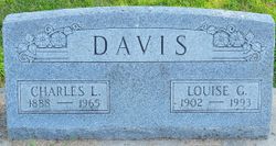
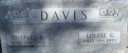
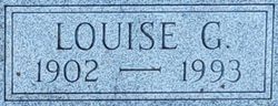
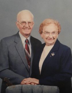
Louise G Mohrhoff Davis
| Birth | : | 10 Sep 1902 Johnson County, Nebraska, USA |
| Death | : | 28 Sep 1993 Tucson, Pima County, Arizona, USA |
| Burial | : | Newcastle Cemetery, Newcastle-under-Lyme, Newcastle-Under-Lyme Borough, England |
| Coordinate | : | 53.0062940, -2.2284440 |
| Plot | : | Block 7 Lot 8 |
| Description | : | Beatrice (NE) Daily Sun, Wed., September 29, 1993, p. 7: TUSCON [sic], Ariz.--Louise G. Davis, 91, Tuscon [sic], Ariz., formerly of Beatrice and Adams, Neb., died in Tucson on Tuesday, Sept. 28, 1993. She was born Sept. 10, 1902, near Sterling, Neb., and moved to a farm near Adams, Neb., in 1908. She and Charles L. Davis were married on Oct. 22, 1929, and they lived in Beatrice, Neb., for 42 years. In 1966, she moved back to Adams, Neb., and then moved to Tucson in 1983. She was employed at the former C.E. Smith Store in Beatrice, Neb.,... Read More |
frequently asked questions (FAQ):
-
Where is Louise G Mohrhoff Davis's memorial?
Louise G Mohrhoff Davis's memorial is located at: Newcastle Cemetery, Newcastle-under-Lyme, Newcastle-Under-Lyme Borough, England.
-
When did Louise G Mohrhoff Davis death?
Louise G Mohrhoff Davis death on 28 Sep 1993 in Tucson, Pima County, Arizona, USA
-
Where are the coordinates of the Louise G Mohrhoff Davis's memorial?
Latitude: 53.0062940
Longitude: -2.2284440
Family Members:
Parent
Spouse

Siblings
Flowers:


Nearby Cemetories:
1. Newcastle Cemetery
Newcastle-under-Lyme, Newcastle-Under-Lyme Borough, England
Coordinate: 53.0062940, -2.2284440
2. St. Giles' Churchyard
Newcastle-under-Lyme, Newcastle-Under-Lyme Borough, England
Coordinate: 53.0115110, -2.2301920
3. St. George's Churchyard
Newcastle-under-Lyme, Newcastle-Under-Lyme Borough, England
Coordinate: 53.0141190, -2.2242070
4. Hartshill Cemetery
Hartshill, Stoke-on-Trent Unitary Authority, England
Coordinate: 53.0054283, -2.2035301
5. Silverdale Cemetery
Silverdale, Newcastle-Under-Lyme Borough, England
Coordinate: 53.0135400, -2.2559520
6. St Thomas the Apostle Churchyard
Penkhull, Stoke-on-Trent Unitary Authority, England
Coordinate: 53.0004170, -2.1964040
7. Newcastle-Under-Lyme Knutton Cemetery
Newcastle-under-Lyme, Newcastle-Under-Lyme Borough, England
Coordinate: 53.0220500, -2.2495100
8. Etruria Methodist Church
Stoke-on-Trent, Stoke-on-Trent Unitary Authority, England
Coordinate: 53.0209680, -2.1985840
9. Quakers Burial Ground
Stoke-on-Trent, Stoke-on-Trent Unitary Authority, England
Coordinate: 53.0052870, -2.1881570
10. St Margaret Churchyard
Wolstanton, Newcastle-Under-Lyme Borough, England
Coordinate: 53.0296810, -2.2154990
11. Hanley Cemetery
Hanley, Stoke-on-Trent Unitary Authority, England
Coordinate: 53.0143330, -2.1863120
12. St. Peter ad Vincula Churchyard
Stoke-on-Trent, Stoke-on-Trent Unitary Authority, England
Coordinate: 53.0041250, -2.1812460
13. St Luke the Evangelist Churchyard
Silverdale, Newcastle-Under-Lyme Borough, England
Coordinate: 53.0170300, -2.2736770
14. St. Mark's Church Graveyard
Shelton, Stoke-on-Trent Unitary Authority, England
Coordinate: 53.0189000, -2.1820000
15. St. Matthias Churchyard
Hanford, Stoke-on-Trent Unitary Authority, England
Coordinate: 52.9812170, -2.1962980
16. Chesterton Cemetery
Newcastle-under-Lyme, Newcastle-Under-Lyme Borough, England
Coordinate: 53.0352240, -2.2500500
17. Keele Cemetery
Keele, Newcastle-Under-Lyme Borough, England
Coordinate: 53.0087192, -2.2813113
18. St John the Baptist Churchyard
Keele, Newcastle-Under-Lyme Borough, England
Coordinate: 53.0039410, -2.2848720
19. Sacred Heart Churchyard
Hanley, Stoke-on-Trent Unitary Authority, England
Coordinate: 53.0210590, -2.1737770
20. Britannia Stadium
Stoke-on-Trent, Stoke-on-Trent Unitary Authority, England
Coordinate: 52.9884070, -2.1754520
21. Holy Trinity Churchyard
Chesterton, Stratford-on-Avon District, England
Coordinate: 53.0418320, -2.2523770
22. St. John the Evangelist Churchyard
Hanley, Stoke-on-Trent Unitary Authority, England
Coordinate: 53.0280200, -2.1749590
23. Christ Church Churchyard
Fenton, Stoke-on-Trent Unitary Authority, England
Coordinate: 52.9977700, -2.1638600
24. St John the Baptist Churchyard
Burslem, Stoke-on-Trent Unitary Authority, England
Coordinate: 53.0425850, -2.1962510