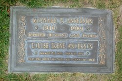
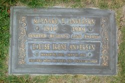
Louise Irene Tastad Anderson
| Birth | : | 31 Mar 1922 Mitchell, Davison County, South Dakota, USA |
| Death | : | 10 May 2011 Los Alamitos, Orange County, California, USA |
| Burial | : | Forest Lawn Memorial Park, Cypress, Orange County, USA |
| Coordinate | : | 33.8339005, -118.0560989 |
| Plot | : | Garden of Protection Lot 5550 Space 2 |
| Description | : | Louise was born in Mitchell, South Dakota, on March 31, 1922. Her parents were George and Minnie (Heintz) Tastad. She had two brothers (Laverne and Harold) and four sisters (M. Darlene, Lola, Maxine and Betty Jane). She grew up in South Dakota but not long after high school, headed for California. On April 10, 1942, she married Maynard Anderson (a man she first met in Mitchell). They were happily married for forth-seven years until Maynard passed away in 1989. During the war years of the early forties, they spent time in Florida and California while Maynard was in the service.... Read More |
frequently asked questions (FAQ):
-
Where is Louise Irene Tastad Anderson's memorial?
Louise Irene Tastad Anderson's memorial is located at: Forest Lawn Memorial Park, Cypress, Orange County, USA.
-
When did Louise Irene Tastad Anderson death?
Louise Irene Tastad Anderson death on 10 May 2011 in Los Alamitos, Orange County, California, USA
-
Where are the coordinates of the Louise Irene Tastad Anderson's memorial?
Latitude: 33.8339005
Longitude: -118.0560989
Family Members:
Flowers:
Nearby Cemetories:
1. Forest Lawn Memorial Park
Cypress, Orange County, USA
Coordinate: 33.8339005, -118.0560989
2. Saint Josephs Episcopal Church Columbarium
Buena Park, Orange County, USA
Coordinate: 33.8415590, -118.0280360
3. Long Beach Police Academy K-9 Cemetery
Long Beach, Los Angeles County, USA
Coordinate: 33.8274000, -118.0895300
4. Artesia Cemetery
Cerritos, Los Angeles County, USA
Coordinate: 33.8717003, -118.0958023
5. Saint Gregory Episcopal Church Columbarium
Long Beach, Los Angeles County, USA
Coordinate: 33.8036100, -118.1105600
6. Christ Lutheran Church Columbarium
Long Beach, Los Angeles County, USA
Coordinate: 33.7952500, -118.1044100
7. Olive Lawn Memorial Park
La Mirada, Los Angeles County, USA
Coordinate: 33.9038700, -118.0114400
8. Magnolia Memorial Park
Garden Grove, Orange County, USA
Coordinate: 33.7843895, -117.9755478
9. Young Israel Cemetery
Norwalk, Los Angeles County, USA
Coordinate: 33.9071000, -118.1081300
10. United States Naval Weapons Station Grounds
Seal Beach, Orange County, USA
Coordinate: 33.7505850, -118.0882970
11. All Souls Cemetery
Long Beach, Los Angeles County, USA
Coordinate: 33.8405991, -118.1647034
12. Palm Cemetery
Long Beach, Los Angeles County, USA
Coordinate: 33.8447200, -118.1682500
13. Cinco Camp Burial Grounds
Cantil, Kern County, USA
Coordinate: 33.9277710, -118.0649960
14. Norwalk State Hospital Cemetery
Norwalk, Los Angeles County, USA
Coordinate: 33.9277710, -118.0649960
15. Forest Lawn Memorial Park
Long Beach, Los Angeles County, USA
Coordinate: 33.8436012, -118.1691971
16. Holy Cross Cemetery
Anaheim, Orange County, USA
Coordinate: 33.8236885, -117.9422226
17. All Saints Anglican Church Columbarium
Long Beach, Los Angeles County, USA
Coordinate: 33.7696600, -118.1461300
18. Little Lake Cemetery
Santa Fe Springs, Los Angeles County, USA
Coordinate: 33.9317900, -118.0779100
19. Westminster Memorial Park
Westminster, Orange County, USA
Coordinate: 33.7489014, -117.9931030
20. Downey District Cemetery
Downey, Los Angeles County, USA
Coordinate: 33.9102783, -118.1399994
21. Long Beach Municipal Cemetery
Long Beach, Los Angeles County, USA
Coordinate: 33.8044700, -118.1769200
22. Paradise Memorial Park
Santa Fe Springs, Los Angeles County, USA
Coordinate: 33.9354540, -118.0869900
23. First Presbyterian Church Memorial Gardens
Fullerton, Orange County, USA
Coordinate: 33.8788600, -117.9417400
24. Sunnyside Cemetery
Long Beach, Los Angeles County, USA
Coordinate: 33.8044700, -118.1789100


