
| Birth | : | 2 Sep 1928 Columbus, Platte County, Nebraska, USA |
| Death | : | 29 Dec 1999 Grand Island, Hall County, Nebraska, USA |
| Burial | : | St. Mark Churchyard, Scarisbrick, West Lancashire District, England |
| Coordinate | : | 53.6134600, -2.9403800 |
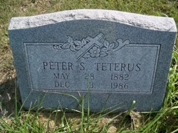
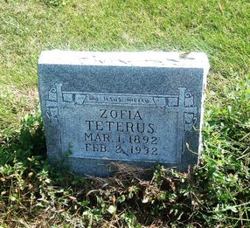
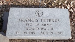
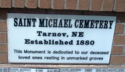
| Description | : | Louise Starostka, 71, of Clarks died Wednesday, Dec. 29, 1999 at Park Place Health Care Center in Grand Island. Mrs. Starostka was born on Sept. 2, 1928 at Columbus to Peter and Sophie (Bogus) Teterus Sr. She grew up in Cornlea. She attended St. Michael's School in Tarnov. She married Clarence "Shorty" Starostka on Sept. 10, 1946 at St. Michael's Catholic Church in Tarnov. They lived in Wisconsin, Palmer and then moved to the Clarks area. They ran Shorty's Bar in Clarks for 45 years. She enjoyed gardening, playing cards and canning. Survivors include her husband... Read More |
frequently asked questions (FAQ):
-
Where is Louise Teterus Starostka's memorial?
Louise Teterus Starostka's memorial is located at: St. Mark Churchyard, Scarisbrick, West Lancashire District, England.
-
When did Louise Teterus Starostka death?
Louise Teterus Starostka death on 29 Dec 1999 in Grand Island, Hall County, Nebraska, USA
-
Where are the coordinates of the Louise Teterus Starostka's memorial?
Latitude: 53.6134600
Longitude: -2.9403800
Family Members:
Parent
Spouse

Siblings


Flowers:


Nearby Cemetories:
1. St. Mark Churchyard
Scarisbrick, West Lancashire District, England
Coordinate: 53.6134600, -2.9403800
2. St. Elizabeth's Churchyard
Scarisbrick, West Lancashire District, England
Coordinate: 53.6124460, -2.9206340
3. Southport Crematorium
Scarisbrick, West Lancashire District, England
Coordinate: 53.6235810, -2.9600210
4. St. Cuthbert's Churchyard
Halsall, West Lancashire District, England
Coordinate: 53.5852140, -2.9529650
5. Ardwick Cemetery
Ardwick, Metropolitan Borough of Manchester, England
Coordinate: 53.6302778, -2.9900000
6. Christ Church Churchyard
Southport, Metropolitan Borough of Sefton, England
Coordinate: 53.6327778, -2.9953770
7. Duke Street Cemetery
Southport, Metropolitan Borough of Sefton, England
Coordinate: 53.6343536, -2.9993131
8. West Lancashire Cemetery and Crematorium
Burscough, West Lancashire District, England
Coordinate: 53.5875500, -2.8820300
9. St Cuthberts Churchyard
Southport, Metropolitan Borough of Sefton, England
Coordinate: 53.6603230, -2.9620310
10. Holy Trinity Church
Southport, Metropolitan Borough of Sefton, England
Coordinate: 53.6503800, -2.9969150
11. Liverpool Road Cemetery
Birkdale, Metropolitan Borough of Sefton, England
Coordinate: 53.6083620, -3.0257140
12. Emmanuel Parish Church
Southport, Metropolitan Borough of Sefton, England
Coordinate: 53.6604534, -2.9748117
13. Emmanuel Church Garden of Remembrance
North Meols, West Lancashire District, England
Coordinate: 53.6607130, -2.9753420
14. Sacred Heart RC Cemetery
Birkdale, Metropolitan Borough of Sefton, England
Coordinate: 53.6066100, -3.0270100
15. St. Marie on the Sands
Southport, Metropolitan Borough of Sefton, England
Coordinate: 53.6524320, -3.0023440
16. St Peter and St Paul Churchyard
Ormskirk, West Lancashire District, England
Coordinate: 53.5692640, -2.8877690
17. Saint Anne's Roman Catholic Church Cemetery
Ormskirk, West Lancashire District, England
Coordinate: 53.5626520, -2.8935560
18. Burscough Priory
Burscough, West Lancashire District, England
Coordinate: 53.5830270, -2.8565030
19. Christ Churchyard
Aughton, West Lancashire District, England
Coordinate: 53.5583510, -2.9046990
20. Saint John Crossens Churchyard
Crossens, Metropolitan Borough of Sefton, England
Coordinate: 53.6733410, -2.9478740
21. St John the Baptist Churchyard
Burscough, West Lancashire District, England
Coordinate: 53.6042760, -2.8401390
22. St John The Evangelist Roman Catholic Church
Burscough, West Lancashire District, England
Coordinate: 53.5902152, -2.8424163
23. St. Stephen's Churchyard
North Meols, West Lancashire District, England
Coordinate: 53.6813720, -2.9248140
24. St Thomas Churchyard
Lydiate, Metropolitan Borough of Sefton, England
Coordinate: 53.5443480, -2.9621640