
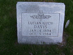
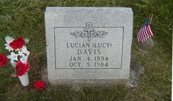
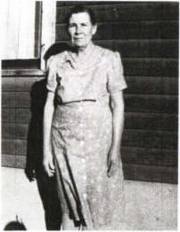
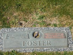
Lucian Amanda “Lucy” Hunt Miller Dunn Davis
| Birth | : | 4 Jan 1894 Rulo, Richardson County, Nebraska, USA |
| Death | : | 5 Oct 1984 USA |
| Burial | : | East Union Cemetery, Manteca, San Joaquin County, USA |
| Coordinate | : | 37.8114014, -121.2350006 |
| Plot | : | Southeast Section |
| Description | : | Falls City Journal – October 5, 1984 Lucian Davis dies early today Lucian (Lucy) Davis, 90, 901 East 11th street, formerly of East View, passed away at 1:40 a.m. today, Friday, Oct. 5, 1984, at her home. She entered Community Hospital on Aug. 17 and on Aug. 25 moved to her present address so she could be cared for by her children and families, Mr. and Mrs. Homer Dunn and Mr. and Mrs. Henry Mullen. She was born Jan. 3, 1894, at Rulo, a daughter of the late William Hunt and Delia Liberty Hunt. She was... Read More |
frequently asked questions (FAQ):
-
Where is Lucian Amanda “Lucy” Hunt Miller Dunn Davis's memorial?
Lucian Amanda “Lucy” Hunt Miller Dunn Davis's memorial is located at: East Union Cemetery, Manteca, San Joaquin County, USA.
-
When did Lucian Amanda “Lucy” Hunt Miller Dunn Davis death?
Lucian Amanda “Lucy” Hunt Miller Dunn Davis death on 5 Oct 1984 in USA
-
Where are the coordinates of the Lucian Amanda “Lucy” Hunt Miller Dunn Davis's memorial?
Latitude: 37.8114014
Longitude: -121.2350006
Family Members:
Parent
Spouse
Siblings
Children

Flowers:


Nearby Cemetories:
1. Park View Cemetery
Manteca, San Joaquin County, USA
Coordinate: 37.8617249, -121.2238312
2. Congregation of Ahavas Achim Cemetery
French Camp, San Joaquin County, USA
Coordinate: 37.8778419, -121.2753067
3. Congregation Adas Yeshuran of Stockton Cemetery
French Camp, San Joaquin County, USA
Coordinate: 37.8784065, -121.2740784
4. Atlanta Cemetery
Five Corners, San Joaquin County, USA
Coordinate: 37.8270035, -121.1420135
5. Chinese Cemetery
French Camp, San Joaquin County, USA
Coordinate: 37.8819962, -121.2805862
6. Ripon Cemetery
Ripon, San Joaquin County, USA
Coordinate: 37.7420311, -121.1238708
7. Collegeville Cemetery
Collegeville, San Joaquin County, USA
Coordinate: 37.9044800, -121.1466141
8. Saint John's Catholic Cemetery
Escalon, San Joaquin County, USA
Coordinate: 37.7994537, -121.0705185
9. Citizens Cemetery
Stockton, San Joaquin County, USA
Coordinate: 37.9559410, -121.2769120
10. Thomas Lindsay Gravesite
San Joaquin County, USA
Coordinate: 37.9573110, -121.2918430
11. David Kelsey Gravesite
Stockton, San Joaquin County, USA
Coordinate: 37.9573110, -121.2918430
12. Temple Israel Cemetery
Stockton, San Joaquin County, USA
Coordinate: 37.9640541, -121.2784348
13. Stockton State Hospital Cemetery
Stockton, San Joaquin County, USA
Coordinate: 37.9663110, -121.2846850
14. San Joaquin Catholic Cemetery
Stockton, San Joaquin County, USA
Coordinate: 37.9707830, -121.2850190
15. Tracy Mausoleum
Tracy, San Joaquin County, USA
Coordinate: 37.7250214, -121.4150696
16. Casa Bonita Mausoleum
Stockton, San Joaquin County, USA
Coordinate: 37.9752340, -121.2877800
17. Tracy Public Cemetery
Tracy, San Joaquin County, USA
Coordinate: 37.7251358, -121.4189453
18. Stockton Woodland Mausoleum
Stockton, San Joaquin County, USA
Coordinate: 37.9762400, -121.2878000
19. Stockton Rural Cemetery
Stockton, San Joaquin County, USA
Coordinate: 37.9794006, -121.2869034
20. Wood Colony Cemetery
Salida, Stanislaus County, USA
Coordinate: 37.6893730, -121.0682144
21. Central United Methodist Church Columbarium
Stockton, San Joaquin County, USA
Coordinate: 37.9825710, -121.3078170
22. Good Shepherd Catholic Cemetery
Modesto, Stanislaus County, USA
Coordinate: 37.6853130, -121.0672890
23. Valpico Memorial Park
Tracy, San Joaquin County, USA
Coordinate: 37.7113260, -121.4656510
24. Highland View Memorial Gardens
Farmington, San Joaquin County, USA
Coordinate: 37.9242935, -121.0008621