
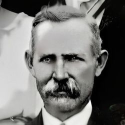
| Birth | : | 26 Nov 1861 Fremont Township, Clarke County, Iowa, USA |
| Death | : | 19 Nov 1946 Jamison, Clarke County, Iowa, USA |
| Burial | : | West Nottingham Cemetery, Colora, Cecil County, USA |
| Coordinate | : | 39.6705110, -76.0760200 |
| Description | : | Lucy Angeline Wells married Clifton Mortimer Smith on March 25, 1890 in the John F. Wells farmhouse, Fremont Township, Clarke County, Iowa. |
frequently asked questions (FAQ):
-
Where is Lucy Angeline Wells Smith's memorial?
Lucy Angeline Wells Smith's memorial is located at: West Nottingham Cemetery, Colora, Cecil County, USA.
-
When did Lucy Angeline Wells Smith death?
Lucy Angeline Wells Smith death on 19 Nov 1946 in Jamison, Clarke County, Iowa, USA
-
Where are the coordinates of the Lucy Angeline Wells Smith's memorial?
Latitude: 39.6705110
Longitude: -76.0760200
Family Members:
Parent

Spouse
Siblings
Children
Flowers:


Nearby Cemetories:
1. West Nottingham Cemetery
Colora, Cecil County, USA
Coordinate: 39.6705110, -76.0760200
2. New Bridge Baptist Church Cemetery
Rising Sun, Cecil County, USA
Coordinate: 39.6854670, -76.0778330
3. Krauss Cemetery
Harrisville, Cecil County, USA
Coordinate: 39.6866989, -76.0744019
4. Harrisville Friends Cemetery
Harrisville, Cecil County, USA
Coordinate: 39.6867140, -76.0788900
5. Colora Friends Meeting Cemetery
Colora, Cecil County, USA
Coordinate: 39.6760187, -76.0980567
6. Brookview Cemetery
Rising Sun, Cecil County, USA
Coordinate: 39.6947630, -76.0694430
7. Hopewell United Methodist Church Cemetery
Woodlawn, Cecil County, USA
Coordinate: 39.6456108, -76.0590820
8. Mount Pleasant Cemetery
Liberty Grove, Cecil County, USA
Coordinate: 39.6706009, -76.1157990
9. Calvary Missionary Baptist Church Cemetery
Rising Sun, Cecil County, USA
Coordinate: 39.7028200, -76.0263000
10. Harmony Chapel Cemetery
Colora, Cecil County, USA
Coordinate: 39.6484100, -76.1357700
11. Ebenezer Cemetery
Rising Sun, Cecil County, USA
Coordinate: 39.6585600, -76.0102800
12. Beaven-Sterrett Farm Cemetery
Port Deposit, Cecil County, USA
Coordinate: 39.6258704, -76.1188198
13. Conowingo Cemetery
Conowingo, Cecil County, USA
Coordinate: 39.6812700, -76.1629800
14. Asbury Cemetery
Port Deposit, Cecil County, USA
Coordinate: 39.6006012, -76.0706024
15. Cokesbury Cemetery
Port Deposit, Cecil County, USA
Coordinate: 39.5988998, -76.0817032
16. Union Cemetery
Nottingham, Chester County, USA
Coordinate: 39.7419000, -76.0651000
17. Trinity Cemetery
Zion, Cecil County, USA
Coordinate: 39.6805992, -75.9816971
18. Brick Meeting House Cemetery
Calvert, Cecil County, USA
Coordinate: 39.7011700, -75.9819800
19. Mount Zoar Cemetery
Conowingo, Cecil County, USA
Coordinate: 39.6852989, -76.1766968
20. Rosebank Cemetery
Calvert, Cecil County, USA
Coordinate: 39.7010994, -75.9805984
21. Marrs Cemetery
Conowingo, Cecil County, USA
Coordinate: 39.6992000, -76.1735100
22. Zion Presbyterian Cemetery
Zion, Cecil County, USA
Coordinate: 39.6767370, -75.9666900
23. Zion Methodist Cemetery
Zion, Cecil County, USA
Coordinate: 39.6761470, -75.9656630
24. Bethesda Cemetery
Cecil County, USA
Coordinate: 39.6960983, -76.1821976