
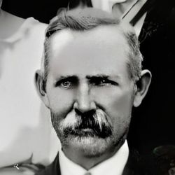
| Birth | : | 11 Feb 1892 Liberty, Clarke County, Iowa, USA |
| Death | : | 19 Mar 1981 Osceola, Clarke County, Iowa, USA |
| Burial | : | Murray Cemetery, Murray, Clarke County, USA |
| Coordinate | : | 41.0278015, -93.9456024 |
| Inscription | : | MILO C SMITH PVT U S Army World War I 1892 - 1981 |
frequently asked questions (FAQ):
-
Where is PVT Milo Clifton Smith's memorial?
PVT Milo Clifton Smith's memorial is located at: Murray Cemetery, Murray, Clarke County, USA.
-
When did PVT Milo Clifton Smith death?
PVT Milo Clifton Smith death on 19 Mar 1981 in Osceola, Clarke County, Iowa, USA
-
Where are the coordinates of the PVT Milo Clifton Smith's memorial?
Latitude: 41.0278015
Longitude: -93.9456024
Family Members:
Parent

Spouse
Siblings
Children

Flowers:


Nearby Cemetories:
1. Murray Cemetery
Murray, Clarke County, USA
Coordinate: 41.0278015, -93.9456024
2. Bell Family Cemetery
Murray, Clarke County, USA
Coordinate: 41.0625267, -93.9240036
3. Sanders Cemetery
Doyle Township, Clarke County, USA
Coordinate: 40.9730000, -93.9016000
4. Claypool Cemetery
Thayer, Union County, USA
Coordinate: 41.0126114, -94.0303497
5. Thayer Catholic Cemetery
Thayer, Union County, USA
Coordinate: 41.0374985, -94.0357971
6. Olinger Cemetery
Union County, USA
Coordinate: 40.9690208, -94.0274887
7. Hopeville Cemetery
Hopeville, Clarke County, USA
Coordinate: 40.9450000, -93.9870000
8. West Union Cemetery
Thayer, Union County, USA
Coordinate: 41.0191994, -94.0721970
9. Bethel Cemetery
Thayer, Union County, USA
Coordinate: 41.0600014, -94.0693970
10. Lacelle Cemetery
Clarke County, USA
Coordinate: 40.9446500, -93.8690300
11. Union Cemetery
Murray, Clarke County, USA
Coordinate: 41.1265000, -93.9115000
12. Beulah Cemetery
Thayer, Union County, USA
Coordinate: 41.0589981, -94.0759964
13. Pierson Cemetery
Osceola, Clarke County, USA
Coordinate: 40.9954491, -93.8131104
14. Monette Cemetery
Lorimor, Union County, USA
Coordinate: 41.0800743, -94.0715866
15. Cox Cemetery
Osceola, Clarke County, USA
Coordinate: 41.0722008, -93.8142014
16. Otterbein Cemetery
Thayer, Union County, USA
Coordinate: 40.9990005, -94.0879974
17. Gregg Cemetery
Doyle Township, Clarke County, USA
Coordinate: 40.9138000, -93.9520000
18. Lorimor Cemetery
Lorimor, Union County, USA
Coordinate: 41.1128006, -94.0516968
19. Browns Mountain Cemetery
Thayer, Union County, USA
Coordinate: 41.0499992, -94.0999985
20. Mount Pisgah Cemetery
Thayer, Union County, USA
Coordinate: 41.0511017, -94.1007996
21. Maple Hill Cemetery
Osceola, Clarke County, USA
Coordinate: 41.0278015, -93.7794037
22. Homewood Cemetery
Thayer, Union County, USA
Coordinate: 40.9220009, -94.0419998
23. Warrick Cemetery
Decatur County, USA
Coordinate: 40.8960000, -93.9234000
24. Leas Cemetery
Union County, USA
Coordinate: 40.9080009, -94.0220032