

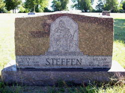
Lucy Ethel Sinnett Steffen
| Birth | : | 15 Mar 1890 Kiowa, Barber County, Kansas, USA |
| Death | : | 6 Jan 1971 Wichita, Sedgwick County, Kansas, USA |
| Burial | : | Harden-Murrumburrah Cemetery, Murrumburrah, Hilltops Council, Australia |
| Coordinate | : | -34.5417750, 148.3273410 |
| Description | : | Married William C. Steffen 8 Jul 1908 Kingman, Kingman, Kansas. Three children were born to their union. _____________________________ Newspaper Clipping MRS. WILLIAM STEFFEN Mrs. Lucy E. Steffen, 80, of Nashville died Wednesday at St. Joseph Hospital. She was taken there last week after suffering extensive burns in a home accident. Funeral services were held Saturday at the United Methodist Church, Zenda, with Rev. Ron Lowry and Rev. Louis Struble officiating. Burial was in Hoosier Cemetery with the Livingston Mortuary in charge. Mrs. Steffen was born March 15, 1890, in Kiowa County, and had lived most of her life in Kingman County. She... Read More |
frequently asked questions (FAQ):
-
Where is Lucy Ethel Sinnett Steffen's memorial?
Lucy Ethel Sinnett Steffen's memorial is located at: Harden-Murrumburrah Cemetery, Murrumburrah, Hilltops Council, Australia.
-
When did Lucy Ethel Sinnett Steffen death?
Lucy Ethel Sinnett Steffen death on 6 Jan 1971 in Wichita, Sedgwick County, Kansas, USA
-
Where are the coordinates of the Lucy Ethel Sinnett Steffen's memorial?
Latitude: -34.5417750
Longitude: 148.3273410
Family Members:
Parent

Spouse
Siblings

Children
Flowers:


Nearby Cemetories:
1. Harden-Murrumburrah Cemetery
Murrumburrah, Hilltops Council, Australia
Coordinate: -34.5417750, 148.3273410
2. St Mark's Anglican Cemetery
Currawong, Hilltops Council, Australia
Coordinate: -34.4645010, 148.3746780
3. Wallendbeen Cemetery
Wallendbeen, Cootamundra-Gundagai Regional Council, Australia
Coordinate: -34.5340990, 148.1525920
4. Wombat Cemetery
Wombat, Hilltops Council, Australia
Coordinate: -34.4250920, 148.2225820
5. Galong Cemetery
Galong, Hilltops Council, Australia
Coordinate: -34.5674060, 148.5600240
6. Galong General Cemetery
Galong, Hilltops Council, Australia
Coordinate: -34.5673520, 148.5601810
7. Young Cemetery
Young, Hilltops Council, Australia
Coordinate: -34.3260670, 148.2882500
8. Young Lawn Cemetery
Young, Hilltops Council, Australia
Coordinate: -34.3245510, 148.2856710
9. Cootamundra General Cemetery
Cootamundra, Cootamundra-Gundagai Regional Council, Australia
Coordinate: -34.6331280, 148.0435500
10. Murringo General Cemetery
Murringo, Hilltops Council, Australia
Coordinate: -34.3195415, 148.4902374
11. Jugiong Catholic
Jugiong, Hilltops Council, Australia
Coordinate: -34.8221590, 148.3467340
12. Jugiong Cemetery
Jugiong, Hilltops Council, Australia
Coordinate: -34.8221590, 148.3467340
13. Lang's Creek Anglican Cemetery
Boorowa, Hilltops Council, Australia
Coordinate: -34.4834250, 148.7037280
14. Muttama Cemetery
Muttama, Cootamundra-Gundagai Regional Council, Australia
Coordinate: -34.8178460, 148.1230180
15. Monteagle Cemetery
Monteagle, Hilltops Council, Australia
Coordinate: -34.2025380, 148.3429110
16. Boorowa Cemetery
Boorowa, Hilltops Council, Australia
Coordinate: -34.4625890, 148.7325800
17. Stockinbingal Cemetery
Stockinbingal, Cootamundra-Gundagai Regional Council, Australia
Coordinate: -34.4900260, 147.8755720
18. Coolac Cemetery
Coolac, Cootamundra-Gundagai Regional Council, Australia
Coordinate: -34.9316600, 148.1664400
19. Bethungra Cemetery
Bethungra, Junee Shire, Australia
Coordinate: -34.7631900, 147.8387300
20. Rye Park Burial Ground
Rye Park, Hilltops Council, Australia
Coordinate: -34.5148850, 148.9090610
21. Rye Park Cemetery
Rye Park, Hilltops Council, Australia
Coordinate: -34.5224260, 148.9286800
22. Frogmore Catholic Cemetery
Frogmore, Hilltops Council, Australia
Coordinate: -34.2712106, 148.8396097
23. Frogmore General Cemetery
Frogmore, Hilltops Council, Australia
Coordinate: -34.2715960, 148.8485260
24. Mitta Mitta Anglican Cemetery
Mitta Mitta, Junee Shire, Australia
Coordinate: -34.8917820, 147.8526410