Ludwig Hermann Bierbaum
| Birth | : | 3 Feb 1876 Clayton County, Iowa, USA |
| Death | : | 5 Aug 1876 Clayton County, Iowa, USA |
| Burial | : | Brockley and Ladywell Cemeteries, Lewisham, London Borough of Lewisham, England |
| Coordinate | : | 51.4570700, -0.0309400 |
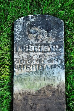
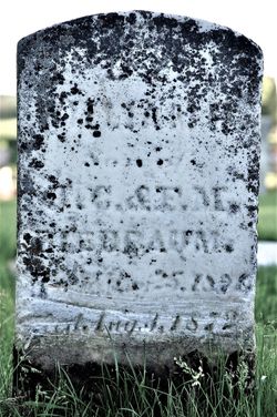
| Description | : | TWELFTH CHILD of Johann Christoph Bierbaum and Florentine (Johanningmier) Bierbaum, Ludwig Hermann Bierbaum was also baptized at his parents' house, in this case one month after birth. He was born February 3, 1876, baptized March 4. His sponsor was Christoph Heinrich Overbeck. (Entry #16, 1876 Births/Baptisms, Immanuel Lutheran Church, Elkport, Clayton County, Iowa) Overbeck was the son-in-law of Ludwig's paternal uncle, Gerhard Heinrich Bierbaum. A 1974 reading of Ludwig's stone provides LUDWIG H., Son of J. C. & F. M. BIERBAUM, BORN Feb. 3, 1876, DIED Aug. 5, 1876. Discrepancy: Entry #10, 1876 Deaths/Burials, St. John Lutheran... Read More |
frequently asked questions (FAQ):
-
Where is Ludwig Hermann Bierbaum's memorial?
Ludwig Hermann Bierbaum's memorial is located at: Brockley and Ladywell Cemeteries, Lewisham, London Borough of Lewisham, England.
-
When did Ludwig Hermann Bierbaum death?
Ludwig Hermann Bierbaum death on 5 Aug 1876 in Clayton County, Iowa, USA
-
Where are the coordinates of the Ludwig Hermann Bierbaum's memorial?
Latitude: 51.4570700
Longitude: -0.0309400
Family Members:
Parent
Siblings
Flowers:
Nearby Cemetories:
1. Brockley and Ladywell Cemeteries
Lewisham, London Borough of Lewisham, England
Coordinate: 51.4570700, -0.0309400
2. Honor Oak Crematorium
Southwark, London Borough of Southwark, England
Coordinate: 51.4536111, -0.0436111
3. St. Mary the Virgin Churchyard
Lewisham, London Borough of Lewisham, England
Coordinate: 51.4556700, -0.0160400
4. Camberwell New Cemetery and Crematorium
Camberwell, London Borough of Southwark, England
Coordinate: 51.4534836, -0.0466380
5. St Augustine Churchyard
Forest Hill, London Borough of Lewisham, England
Coordinate: 51.4503260, -0.0508140
6. Nunhead Cemetery
Nunhead, London Borough of Southwark, England
Coordinate: 51.4642296, -0.0530430
7. Camberwell Old Cemetery
Camberwell, London Borough of Southwark, England
Coordinate: 51.4507866, -0.0586410
8. Old St. Margaret's Churchyard
Lee, London Borough of Lewisham, England
Coordinate: 51.4633010, 0.0001900
9. St. Margaret's of Antioch Churchyard
Lee Green, London Borough of Lewisham, England
Coordinate: 51.4628430, 0.0008400
10. Christ Church with St Paul
Forest Hill, London Borough of Lewisham, England
Coordinate: 51.4380725, -0.0483308
11. St Paul Churchyard
Deptford, London Borough of Lewisham, England
Coordinate: 51.4795920, -0.0244260
12. Unitarian Baptist Chapel Chapelyard
Deptford, London Borough of Lewisham, England
Coordinate: 51.4801250, -0.0234300
13. St. Nicholas Churchyard Extension
Deptford, London Borough of Lewisham, England
Coordinate: 51.4819870, -0.0237210
14. St Nicholas Churchyard
Deptford, London Borough of Lewisham, England
Coordinate: 51.4819610, -0.0227660
15. St. Alfege Churchyard
Greenwich, Royal Borough of Greenwich, England
Coordinate: 51.4804610, -0.0097090
16. Royal Observatory
Greenwich, Royal Borough of Greenwich, England
Coordinate: 51.4778110, -0.0014750
17. Observant Friars Churchyard
Greenwich, Royal Borough of Greenwich, England
Coordinate: 51.4825810, -0.0097240
18. Friends Burial Ground (Defunct)
Peckham, London Borough of Southwark, England
Coordinate: 51.4716810, -0.0709110
19. Hither Green Cemetery and Crematorium
Lewisham, London Borough of Lewisham, England
Coordinate: 51.4387050, 0.0057590
20. Old Royal Naval College Chapel
Greenwich, Royal Borough of Greenwich, England
Coordinate: 51.4822650, -0.0056610
21. Bellot Memorial
Greenwich, Royal Borough of Greenwich, England
Coordinate: 51.4836700, -0.0078360
22. Congregational Chapel Chapelyard
Greenwich, Royal Borough of Greenwich, England
Coordinate: 51.4819930, 0.0003560
23. St Bartholomew Churchyard
Sydenham, London Borough of Lewisham, England
Coordinate: 51.4279460, -0.0581620
24. Dulwich Old Burial Ground
Dulwich, London Borough of Southwark, England
Coordinate: 51.4506000, -0.0851000

