
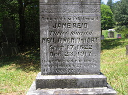

Lydia Jane Reid DeHart
| Birth | : | 17 Sep 1822 Burke County, North Carolina, USA |
| Death | : | 23 Dec 1917 De Hart Mill, Swain County, North Carolina, USA |
| Burial | : | Resurrection Cemetery, Wyoming, Kent County, USA |
| Coordinate | : | 42.8905983, -85.6819000 |
| Inscription | : | I have finished the work which you gavest me to do. |
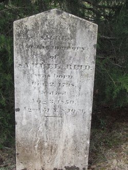
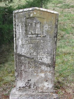
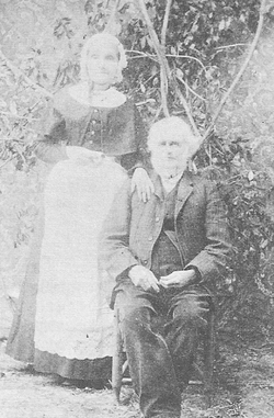
| Description | : | Jane was born on a farm near Morganton, NC to Samuel and Nancy London Reid. They, and other relatives moved to Burning Town, Macon County, before 1850. Jane' sweetheart Andrew Neill followed them, and he and Jane soon married. They joined family members heading west, but stopped to purchase land in McMinn County, TN where their two daughters were born. Homesickness overcame them, and soon they returned to Macon County and settled near her parents. Two tragedies struck Jane: Andrew died of typhoid in 1850, and her father died the same week. A year later, the young widow married widower... Read More |
frequently asked questions (FAQ):
-
Where is Lydia Jane Reid DeHart's memorial?
Lydia Jane Reid DeHart's memorial is located at: Resurrection Cemetery, Wyoming, Kent County, USA.
-
When did Lydia Jane Reid DeHart death?
Lydia Jane Reid DeHart death on 23 Dec 1917 in De Hart Mill, Swain County, North Carolina, USA
-
Where are the coordinates of the Lydia Jane Reid DeHart's memorial?
Latitude: 42.8905983
Longitude: -85.6819000
Family Members:
Parent
Spouse
Siblings
Children
Flowers:


Nearby Cemetories:
1. Resurrection Cemetery
Wyoming, Kent County, USA
Coordinate: 42.8905983, -85.6819000
2. Holy Trinity Columbarium
Wyoming, Kent County, USA
Coordinate: 42.8669010, -85.6847490
3. Rest Lawn Memorial Park
Grand Rapids, Kent County, USA
Coordinate: 42.9007988, -85.6438980
4. Pine Hill Cemetery
Kentwood, Kent County, USA
Coordinate: 42.8675003, -85.6363983
5. Oak Grove Cemetery
Grand Rapids, Kent County, USA
Coordinate: 42.9136009, -85.6314011
6. Woodlawn Cemetery
Grand Rapids, Kent County, USA
Coordinate: 42.9160995, -85.6303024
7. Maple Grove Cemetery
Kentwood, Kent County, USA
Coordinate: 42.9033300, -85.6203400
8. Garfield Park Cemetery
Grand Rapids, Kent County, USA
Coordinate: 42.9221992, -85.6307983
9. Grandville Cemetery
Grandville, Kent County, USA
Coordinate: 42.9043999, -85.7514038
10. Oakhill Cemetery
Grand Rapids, Kent County, USA
Coordinate: 42.9411011, -85.6517029
11. Kent Memorial Gardens
Byron Center, Kent County, USA
Coordinate: 42.8356018, -85.6883011
12. Sleepy Hollow Pet Cemetery and Crematory
Byron Center, Kent County, USA
Coordinate: 42.8477040, -85.7329940
13. Saint Andrews Catholic Cemetery
Grand Rapids, Kent County, USA
Coordinate: 42.9463997, -85.6567001
14. Blain Cemetery
Cutlerville, Kent County, USA
Coordinate: 42.8414001, -85.6335983
15. Grace Episcopal Church Columbarium
Grand Rapids, Kent County, USA
Coordinate: 42.9413390, -85.6242730
16. Winchester Cemetery
Byron Center, Kent County, USA
Coordinate: 42.8246994, -85.6980972
17. Boynton Cemetery
Byron Center, Kent County, USA
Coordinate: 42.8377991, -85.7433014
18. Westminster Presbyterian Church Columbarium
Grand Rapids, Kent County, USA
Coordinate: 42.9619070, -85.6646760
19. First United Methodist Church Columbarium
Grand Rapids, Kent County, USA
Coordinate: 42.9634200, -85.6633300
20. Central Reformed Church Crypt
Grand Rapids, Kent County, USA
Coordinate: 42.9634410, -85.6563430
21. Gerald R Ford Museum
Grand Rapids, Kent County, USA
Coordinate: 42.9668140, -85.6771000
22. Fulton Street Cemetery
Grand Rapids, Kent County, USA
Coordinate: 42.9639200, -85.6486400
23. River Bend Cemetery
Walker, Kent County, USA
Coordinate: 42.9352989, -85.7750015
24. Weaver Cemetery
Byron Township, Kent County, USA
Coordinate: 42.8041992, -85.6828003