| Birth | : | 8 Oct 1924 |
| Death | : | 19 Mar 1946 California, USA |
| Burial | : | Whitman Cemetery, Whitman, Grant County, USA |
| Coordinate | : | 42.0365982, -101.5188980 |
| Inscription | : | NEBRASKA MM3 U. S. NAVY WORLD WAR II |
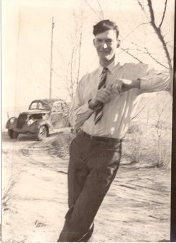
| Description | : | Bio courtesy Tim Cook (#46481904) Lyle Dykes was killed in the crash of U.S. Army Air Corps C-47B-50 transport #45-1085 when it mysteriously exploded in flight and crashed near Hobard Mills, 11 miles north of Truckee, California. The plane departed Stockton, with destinations to Ogden, Utah and Denver, Colorado with 23 Army and Navy personnel destined for discharge from military service, and three crewmembers. All aboard perished. One of the passengers aboard was Lt. Cdr. Lloyd Stark, son of former Missouri governor Lloyd Stark. |
frequently asked questions (FAQ):
-
Where is Lyle Christie Dykes's memorial?
Lyle Christie Dykes's memorial is located at: Whitman Cemetery, Whitman, Grant County, USA.
-
When did Lyle Christie Dykes death?
Lyle Christie Dykes death on 19 Mar 1946 in California, USA
-
Where are the coordinates of the Lyle Christie Dykes's memorial?
Latitude: 42.0365982
Longitude: -101.5188980
Family Members:
Parent
Siblings
Flowers:
Nearby Cemetories:
1. Whitman Cemetery
Whitman, Grant County, USA
Coordinate: 42.0365982, -101.5188980
2. Hyannis Cemetery
Hyannis, Grant County, USA
Coordinate: 41.9995960, -101.7706760
3. Hecla Graves
Hecla, Hooker County, USA
Coordinate: 42.0376840, -101.2346040
4. Ashby Cemetery
Ashby, Grant County, USA
Coordinate: 42.0172700, -101.9118300
5. Curtis Cemetery
Cherry County, USA
Coordinate: 42.3414500, -101.5631500
6. Perrett-Stansbie Cemetery
Cherry County, USA
Coordinate: 42.1702500, -101.9087500
7. Eclipse Cemetery
Mullen, Hooker County, USA
Coordinate: 41.7705500, -101.2592000
8. Cedarview Cemetery
Mullen, Hooker County, USA
Coordinate: 42.0439491, -101.0372009
9. Dry Valley Cemetery
Cherry County, USA
Coordinate: 42.2640300, -101.0857200
10. Virginia Cemetery
Valentine, Cherry County, USA
Coordinate: 42.1432000, -100.9761000
11. James Cemetery
Cherry County, USA
Coordinate: 42.1436005, -100.9760971
12. Bingham Cemetery
Bingham, Sheridan County, USA
Coordinate: 42.0211390, -102.0800150
13. Center Valley Baptist Church Cemetery
Arthur, Arthur County, USA
Coordinate: 41.6010900, -101.4646900
14. Arthur Cemetery
Arthur, Arthur County, USA
Coordinate: 41.5646530, -101.7058360
15. Seneca Cemetery
Seneca, Thomas County, USA
Coordinate: 42.0364990, -100.8328018
16. Hollowell Cemetery
Gordon, Sheridan County, USA
Coordinate: 42.3296100, -102.0885500
17. Wolfenden Cemetery
Kennedy, Cherry County, USA
Coordinate: 42.4928500, -101.1621000
18. Jimtown Cemetery
Brownlee, Cherry County, USA
Coordinate: 42.1174000, -100.8014500
19. Ellsworth Catholic Cemetery
Sheridan County, USA
Coordinate: 42.0575320, -102.2799959
20. Long Cemetery
Cherry County, USA
Coordinate: 42.2932000, -100.8156000
21. Pleasant Point Cemetery
Gordon, Sheridan County, USA
Coordinate: 42.3274110, -102.2002530
22. Mari Sandoz Museum
Gordon, Sheridan County, USA
Coordinate: 42.3857010, -102.1575270
23. DeWitty Cemetery
Brownlee, Cherry County, USA
Coordinate: 42.3714000, -100.8296000
24. Emanuel Gravesite
Brownlee, Cherry County, USA
Coordinate: 42.3514000, -100.8021500


