
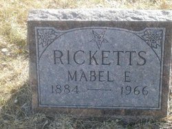
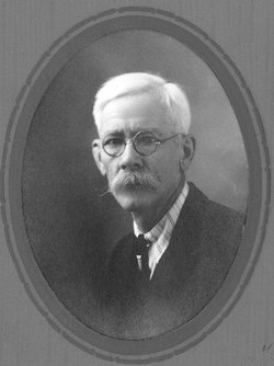
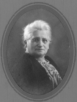
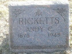
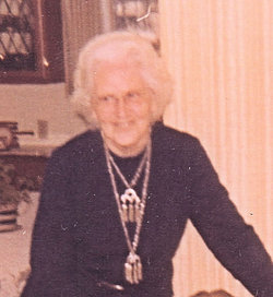
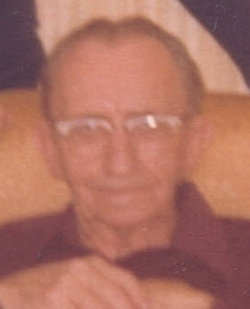
Mabel Ella “Nibs” Barkley Ricketts
| Birth | : | 7 Mar 1884 Blunt, Hughes County, South Dakota, USA |
| Death | : | 5 Apr 1966 Fort Pierre, Stanley County, South Dakota, USA |
| Burial | : | Blain Cemetery, Cutlerville, Kent County, USA |
| Coordinate | : | 42.8414001, -85.6335983 |
| Description | : | Mabel Ella was born 7 Mar 1884 in Blunt, Hughes, South Dakota. Mabel Ella "Nibs" married Andy C. Ricketts at her parents home on the south side of Bad River. She was a member in the Congregational church and Order of the Eastern Star. She was active in various women's groups. She died at St. Mary's Hospital in Pierre in 1966. Burial was at Scotty Phillips Cemetery, Ft. Pierre, South Dakota. |
frequently asked questions (FAQ):
-
Where is Mabel Ella “Nibs” Barkley Ricketts's memorial?
Mabel Ella “Nibs” Barkley Ricketts's memorial is located at: Blain Cemetery, Cutlerville, Kent County, USA.
-
When did Mabel Ella “Nibs” Barkley Ricketts death?
Mabel Ella “Nibs” Barkley Ricketts death on 5 Apr 1966 in Fort Pierre, Stanley County, South Dakota, USA
-
Where are the coordinates of the Mabel Ella “Nibs” Barkley Ricketts's memorial?
Latitude: 42.8414001
Longitude: -85.6335983
Family Members:
Parent
Spouse
Siblings

Children
Flowers:


Nearby Cemetories:
1. Blain Cemetery
Cutlerville, Kent County, USA
Coordinate: 42.8414001, -85.6335983
2. Pine Hill Cemetery
Kentwood, Kent County, USA
Coordinate: 42.8675003, -85.6363983
3. Dutton Cemetery
Dutton, Kent County, USA
Coordinate: 42.8366670, -85.5841670
4. Kent Memorial Gardens
Byron Center, Kent County, USA
Coordinate: 42.8356018, -85.6883011
5. Gaines Cemetery
Cutlerville, Kent County, USA
Coordinate: 42.7976036, -85.6240311
6. Holy Trinity Columbarium
Wyoming, Kent County, USA
Coordinate: 42.8669010, -85.6847490
7. Winchester Cemetery
Byron Center, Kent County, USA
Coordinate: 42.8246994, -85.6980972
8. Weaver Cemetery
Byron Township, Kent County, USA
Coordinate: 42.8041992, -85.6828003
9. Rest Lawn Memorial Park
Grand Rapids, Kent County, USA
Coordinate: 42.9007988, -85.6438980
10. Resurrection Cemetery
Wyoming, Kent County, USA
Coordinate: 42.8905983, -85.6819000
11. Maple Grove Cemetery
Kentwood, Kent County, USA
Coordinate: 42.9033300, -85.6203400
12. Oak Grove Cemetery
Grand Rapids, Kent County, USA
Coordinate: 42.9136009, -85.6314011
13. Sleepy Hollow Pet Cemetery and Crematory
Byron Center, Kent County, USA
Coordinate: 42.8477040, -85.7329940
14. Woodlawn Cemetery
Grand Rapids, Kent County, USA
Coordinate: 42.9160995, -85.6303024
15. Boynton Cemetery
Byron Center, Kent County, USA
Coordinate: 42.8377991, -85.7433014
16. Garfield Park Cemetery
Grand Rapids, Kent County, USA
Coordinate: 42.9221992, -85.6307983
17. Saint Marys Catholic Cemetery
Cascade Township, Kent County, USA
Coordinate: 42.8688890, -85.5283330
18. Holy Corners Cemetery
Caledonia, Kent County, USA
Coordinate: 42.8122220, -85.5272220
19. Chapel Hill Memorial Gardens
Cascade Township, Kent County, USA
Coordinate: 42.9089012, -85.5464020
20. Winegar Cemetery
Byron Center, Kent County, USA
Coordinate: 42.7933006, -85.7497025
21. Grace Episcopal Church Columbarium
Grand Rapids, Kent County, USA
Coordinate: 42.9413390, -85.6242730
22. Oakhill Cemetery
Grand Rapids, Kent County, USA
Coordinate: 42.9411011, -85.6517029
23. Teeple Cemetery (Defunct)
Cascade Township, Kent County, USA
Coordinate: 42.9134300, -85.5357790
24. Jones Cemetery
Dorr, Allegan County, USA
Coordinate: 42.7578011, -85.7130966