
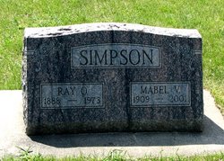
Mabel Folsom Simpson
| Birth | : | 24 May 1909 Postville, Allamakee County, Iowa, USA |
| Death | : | 25 Feb 2001 Spring Park, Hennepin County, Minnesota, USA |
| Burial | : | Osage Cemetery, Osage, Mitchell County, USA |
| Coordinate | : | 43.2916700, -92.8201700 |
| Description | : | MABEL SIMPSON OSAGE - Mabel Simpson, 91, formerly of Osage, died Sunday (Feb. 25, 2001) at the Presbyterian Homes of Lake Minnetonka in Spring Park, Minn., of natural causes. Mabel was born May 24, 1909, at Postville, the daughter of Alonzo and Hazel (Harris) Folsom. Mabel was united in marriage to Ray Simpson on April 6, 1929, at Albert Lea, Minn. They made their home on a farm between Osage and Orchard. Mabel also worked at the Osage Memorial Hospital for a time. Ray passed away in 1973. In 1974, Mabel moved to the Minneapolis area, where she did volunteer... Read More |
frequently asked questions (FAQ):
-
Where is Mabel Folsom Simpson's memorial?
Mabel Folsom Simpson's memorial is located at: Osage Cemetery, Osage, Mitchell County, USA.
-
When did Mabel Folsom Simpson death?
Mabel Folsom Simpson death on 25 Feb 2001 in Spring Park, Hennepin County, Minnesota, USA
-
Where are the coordinates of the Mabel Folsom Simpson's memorial?
Latitude: 43.2916700
Longitude: -92.8201700
Family Members:
Parent

Spouse

Siblings

Flowers:


Nearby Cemetories:
1. Osage Cemetery
Osage, Mitchell County, USA
Coordinate: 43.2916700, -92.8201700
2. Sacred Heart Cemetery
Osage, Mitchell County, USA
Coordinate: 43.2742004, -92.7917023
3. South Osage Mennonite Church Cemetery
Osage, Mitchell County, USA
Coordinate: 43.2544556, -92.7915573
4. Tucker Cemetery
Osage, Mitchell County, USA
Coordinate: 43.2494011, -92.8319016
5. Oak Grove Cemetery
Mitchell, Mitchell County, USA
Coordinate: 43.3156013, -92.8707962
6. Calvary Cemetery
Osage, Mitchell County, USA
Coordinate: 43.2238998, -92.8300018
7. Orchard Cemetery
Orchard, Mitchell County, USA
Coordinate: 43.2249985, -92.7838898
8. Dudley Cemetery
Dudley (historical), Mitchell County, USA
Coordinate: 43.2252998, -92.8743973
9. Riverview Cemetery
Saint Ansgar, Mitchell County, USA
Coordinate: 43.3430328, -92.9220200
10. Rock Creek Cemetery
Meroa, Mitchell County, USA
Coordinate: 43.2352791, -92.9225006
11. Eden Presbyterian Cemetery
Meroa, Mitchell County, USA
Coordinate: 43.2131004, -92.9103012
12. West End Cemetery
Meroa, Mitchell County, USA
Coordinate: 43.2216682, -92.9250031
13. Saint Ansgar Cemetery
Saint Ansgar, Mitchell County, USA
Coordinate: 43.3777809, -92.9094391
14. Immanuel Lutheran Cemetery
Saint Ansgar, Mitchell County, USA
Coordinate: 43.3717003, -92.9257965
15. First Lutheran Cemetery
Saint Ansgar, Mitchell County, USA
Coordinate: 43.3841705, -92.9194412
16. Liberty Cemetery
Little Cedar, Mitchell County, USA
Coordinate: 43.3856010, -92.7230988
17. Beaver Creek Cemetery
Brownville, Mitchell County, USA
Coordinate: 43.3397217, -92.6727829
18. Blakestad Cemetery
Saint Ansgar, Mitchell County, USA
Coordinate: 43.3711014, -92.9400024
19. Saint Johns Lutheran Cemetery
Rock Creek, Mitchell County, USA
Coordinate: 43.3295560, -92.9849770
20. Saint Peters Cemetery
New Haven, Mitchell County, USA
Coordinate: 43.2858315, -92.6427765
21. Saint Johns Lutheran Old Cemetery
Rock Creek, Mitchell County, USA
Coordinate: 43.3313904, -92.9897232
22. Stillwater Cemetery
Orchard, Mitchell County, USA
Coordinate: 43.2130585, -92.6780624
23. McKinley Cemetery
Saint Ansgar, Mitchell County, USA
Coordinate: 43.3906400, -92.9368300
24. Howardville Cemetery
Floyd, Floyd County, USA
Coordinate: 43.1866989, -92.7016983