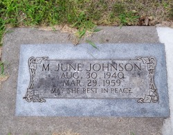
Mabel June Johnson
| Birth | : | 30 Aug 1940 Newcastle, Dixon County, Nebraska, USA |
| Death | : | 29 Mar 1959 Columbus, Platte County, Nebraska, USA |
| Burial | : | St Ambrose Churchyard, Grindleton, Ribble Valley Borough, England |
| Coordinate | : | 53.9061710, -2.3633270 |
| Description | : | WEB Site; http://rootsweb.ancestry.com/~neplatte/vitals/vitals1959.html The Columbus Daily Telegram, March 31, 1959 JOHNSON--Columbus girl found dead in cabin An 18-year-old Columbus girl, Mabel June Johnson, was found dead in a cabin at the Parkview Courts in south Columbus shortly after 6 o'clock Monday evening. County Attorney and Coroner C. Thomas White said the girl apparently died from accidental suffocation. The last time the girl was seen alive was about 10 p.m. Saturday. Her body was discovered by a sister-in-law, Mrs. Virgil Johnson, who lives in a trailer house nearby. Miss Johnson had... Read More |
frequently asked questions (FAQ):
-
Where is Mabel June Johnson's memorial?
Mabel June Johnson's memorial is located at: St Ambrose Churchyard, Grindleton, Ribble Valley Borough, England.
-
When did Mabel June Johnson death?
Mabel June Johnson death on 29 Mar 1959 in Columbus, Platte County, Nebraska, USA
-
Where are the coordinates of the Mabel June Johnson's memorial?
Latitude: 53.9061710
Longitude: -2.3633270
Family Members:
Parent
Siblings
Flowers:
Nearby Cemetories:
1. St Ambrose Churchyard
Grindleton, Ribble Valley Borough, England
Coordinate: 53.9061710, -2.3633270
2. Grindleton Methodist Cemetery
Grindleton, Ribble Valley Borough, England
Coordinate: 53.9080420, -2.3684420
3. Christ Churchyard
Chatburn, Ribble Valley Borough, England
Coordinate: 53.8940690, -2.3515030
4. Sawley Abbey
Sawley, Ribble Valley Borough, England
Coordinate: 53.9131920, -2.3417080
5. St. Leonard's Churchyard
Downham, Ribble Valley Borough, England
Coordinate: 53.8944340, -2.3294250
6. St Helen Churchyard
Waddington, Ribble Valley Borough, England
Coordinate: 53.8898700, -2.4143900
7. St. Joseph's Roman Catholic Cemetery
Clitheroe, Ribble Valley Borough, England
Coordinate: 53.8770700, -2.3960000
8. Clitheroe Cemetery
Clitheroe, Ribble Valley Borough, England
Coordinate: 53.8779250, -2.3984550
9. St Mary Magdalene Churchyard
Clitheroe, Ribble Valley Borough, England
Coordinate: 53.8740980, -2.3903420
10. Holden Chapel
Bolton-by-Bowland, Ribble Valley Borough, England
Coordinate: 53.9420850, -2.3500060
11. St Peter and St Paul Churchyard
Bolton-by-Bowland, Ribble Valley Borough, England
Coordinate: 53.9399800, -2.3270300
12. Trinity Methodist Churchyard
Clitheroe, Ribble Valley Borough, England
Coordinate: 53.8709060, -2.3954550
13. St James Churchyard
Clitheroe, Ribble Valley Borough, England
Coordinate: 53.8659600, -2.3922700
14. Twiston Quaker Burial Ground
Clitheroe, Ribble Valley Borough, England
Coordinate: 53.8854210, -2.2838840
15. Salem Congregational Chapel Martin Top
Rimington, Ribble Valley Borough, England
Coordinate: 53.9072484, -2.2740463
16. St. Mary the Virgin Churchyard
Gisburn, Ribble Valley Borough, England
Coordinate: 53.9356080, -2.2605210
17. All Hallows Churchyard
Great Mitton, Ribble Valley Borough, England
Coordinate: 53.8461500, -2.4339000
18. Saint Nicholas Parish Churchyard
Sabden, Ribble Valley Borough, England
Coordinate: 53.8346503, -2.3332764
19. St Andrew Churchyard
Slaidburn, Ribble Valley Borough, England
Coordinate: 53.9641600, -2.4437090
20. St. Mary's Churchyard
Newchurch in Pendle, Pendle Borough, England
Coordinate: 53.8504181, -2.2706807
21. Queen Mary's Military Hospital Cemetery
Whalley, Ribble Valley Borough, England
Coordinate: 53.8337490, -2.4127930
22. Calderstones Hospital Cemetery
Whalley, Ribble Valley Borough, England
Coordinate: 53.8338710, -2.4147160
23. Whalley, Wiswell and Barrow Cemetery
Whalley, Ribble Valley Borough, England
Coordinate: 53.8308490, -2.4057280
24. Saint Mary and All Saints Churchyard
Whalley, Ribble Valley Borough, England
Coordinate: 53.8211890, -2.4078080


