
| Birth | : | 16 Feb 1908 Loup County, Nebraska, USA |
| Death | : | 16 Jun 1982 Loup County, Nebraska, USA |
| Burial | : | Taylor Cemetery, Taylor, Loup County, USA |
| Coordinate | : | 41.7571983, -99.3861008 |
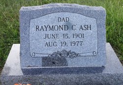
| Description | : | Mabel is the daughter of Eva Della Dye and Commadore Perry Dye According to Janis Dye Derby she married Raymond Ash in Taylor, Nebraska on December 7, 1929. She married Bob Howard on June 7, 1974, Bob died December 1979. On May 14, 1982 she married John Kettleborough while living in Key Villa. |
frequently asked questions (FAQ):
-
Where is Mabel Mildred Dye Kettleborough's memorial?
Mabel Mildred Dye Kettleborough's memorial is located at: Taylor Cemetery, Taylor, Loup County, USA.
-
When did Mabel Mildred Dye Kettleborough death?
Mabel Mildred Dye Kettleborough death on 16 Jun 1982 in Loup County, Nebraska, USA
-
Where are the coordinates of the Mabel Mildred Dye Kettleborough's memorial?
Latitude: 41.7571983
Longitude: -99.3861008
Family Members:
Parent

Spouse
Siblings
Flowers:


Nearby Cemetories:
1. Kent Cemetery
Taylor, Loup County, USA
Coordinate: 41.7416992, -99.3088989
2. Mount Hope Cemetery
Sargent, Custer County, USA
Coordinate: 41.6768990, -99.3855972
3. Saint Marys Cemetery
Sargent, Custer County, USA
Coordinate: 41.6768990, -99.4044037
4. West Union Cemetery
Sargent, Custer County, USA
Coordinate: 41.6763992, -99.4608002
5. Madison Square Cemetery
Taylor, Loup County, USA
Coordinate: 41.7694016, -99.5314026
6. Almeria Cemetery
Almeria, Loup County, USA
Coordinate: 41.8177986, -99.5128021
7. Predmore Cemetery
Walworth, Custer County, USA
Coordinate: 41.6755981, -99.5674973
8. Jack Shafer Memorial Cemetery
Burwell, Garfield County, USA
Coordinate: 41.8202200, -99.1835500
9. Parker Cemetery
Burwell, Garfield County, USA
Coordinate: 41.8203011, -99.1821976
10. Bohemian Brotherhood Cemetery
Elyria, Valley County, USA
Coordinate: 41.6618996, -99.1866989
11. Moulton Cemetery
Loup County, USA
Coordinate: 41.8574982, -99.5852966
12. Somerford Cemetery
Sargent, Custer County, USA
Coordinate: 41.5793991, -99.4328003
13. Cottonwood Cemetery
Burwell, Garfield County, USA
Coordinate: 41.7681007, -99.1418991
14. Littlefield Cemetery
Burwell, Garfield County, USA
Coordinate: 41.8093987, -99.1389008
15. Longwood Cemetery
Comstock, Custer County, USA
Coordinate: 41.5966988, -99.2356033
16. Banner Cemetery
Burwell, Garfield County, USA
Coordinate: 41.8031006, -99.1235962
17. Round Valley Cemetery
Custer County, USA
Coordinate: 41.5758018, -99.5180969
18. Boleszyn Cemetery
Elyria, Valley County, USA
Coordinate: 41.6691000, -99.1315000
19. Gates Cemetery
Gates, Custer County, USA
Coordinate: 41.6492004, -99.6361008
20. Czech National Cemetery
Valley County, USA
Coordinate: 41.6250000, -99.1537000
21. Douglas Grove Cemetery
Comstock, Custer County, USA
Coordinate: 41.5489006, -99.2881012
22. Potter Brown Cemetery
Burwell, Garfield County, USA
Coordinate: 41.7489000, -99.0668500
23. Saint Wenceslaus Catholic Cemetery
Valley County, USA
Coordinate: 41.6103000, -99.1336000
24. Round Park Cemetery
Valley County, USA
Coordinate: 41.5525017, -99.1825027