

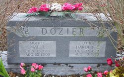
Mae Lena Maley Dozier
| Birth | : | 15 Jul 1913 Mildred, Allen County, Kansas, USA |
| Death | : | 22 Aug 2003 Fort Scott, Bourbon County, Kansas, USA |
| Burial | : | Chapel Hill Memorial Gardens, Cascade Township, Kent County, USA |
| Coordinate | : | 42.9089012, -85.5464020 |
| Description | : | Chanute Tribune, The (KS) - Tuesday, August 26, 2003 FORT SCOTT - Mae Lena Dozier, 90, Moran, died Friday, Aug. 22, 2003, at Mercy Hospital in Ft. Scott. She was born July 15, 1913, in rural Mildred, the daughter of Chester C. and Helena Heider Maley. She grew up in rural LaHarpe. She moved to Arkansas when she was 12, living near Gravett and Decater for a year. She then returned to the LaHarpe area and completed her schooling. She then moved to rural Moran, where she lived for 72 years. As a seamstress, she designed garments that appeared on television's... Read More |
frequently asked questions (FAQ):
-
Where is Mae Lena Maley Dozier's memorial?
Mae Lena Maley Dozier's memorial is located at: Chapel Hill Memorial Gardens, Cascade Township, Kent County, USA.
-
When did Mae Lena Maley Dozier death?
Mae Lena Maley Dozier death on 22 Aug 2003 in Fort Scott, Bourbon County, Kansas, USA
-
Where are the coordinates of the Mae Lena Maley Dozier's memorial?
Latitude: 42.9089012
Longitude: -85.5464020
Family Members:
Spouse
Flowers:


Nearby Cemetories:
1. Chapel Hill Memorial Gardens
Cascade Township, Kent County, USA
Coordinate: 42.9089012, -85.5464020
2. Teeple Cemetery (Defunct)
Cascade Township, Kent County, USA
Coordinate: 42.9134300, -85.5357790
3. Martin Cemetery
Grand Rapids, Kent County, USA
Coordinate: 42.9458008, -85.5607986
4. Graceland Memorial Park and Mausoleum
Grand Rapids, Kent County, USA
Coordinate: 42.9481010, -85.5618973
5. Cascade Cemetery
Cascade Township, Kent County, USA
Coordinate: 42.9088890, -85.4905560
6. Saint Marys Catholic Cemetery
Cascade Township, Kent County, USA
Coordinate: 42.8688890, -85.5283330
7. Forest Hills Presbyterian Church Columbarium
Cascade Township, Kent County, USA
Coordinate: 42.8981194, -85.4814083
8. Maple Grove Cemetery
Kentwood, Kent County, USA
Coordinate: 42.9033300, -85.6203400
9. DeVos Family Memorial Garden
Ada, Kent County, USA
Coordinate: 42.9493690, -85.4913280
10. Ada Cemetery
Ada, Kent County, USA
Coordinate: 42.9625015, -85.5046997
11. Woodlawn Cemetery
Grand Rapids, Kent County, USA
Coordinate: 42.9160995, -85.6303024
12. Oak Grove Cemetery
Grand Rapids, Kent County, USA
Coordinate: 42.9136009, -85.6314011
13. Garfield Park Cemetery
Grand Rapids, Kent County, USA
Coordinate: 42.9221992, -85.6307983
14. Grace Episcopal Church Columbarium
Grand Rapids, Kent County, USA
Coordinate: 42.9413390, -85.6242730
15. Rest Lawn Memorial Park
Grand Rapids, Kent County, USA
Coordinate: 42.9007988, -85.6438980
16. Dutton Cemetery
Dutton, Kent County, USA
Coordinate: 42.8366670, -85.5841670
17. Frederik Meijer Gardens and Sculpture Park
Grand Rapids, Kent County, USA
Coordinate: 42.9794880, -85.5897510
18. Pine Hill Cemetery
Kentwood, Kent County, USA
Coordinate: 42.8675003, -85.6363983
19. Whitneyville Cemetery
Whitneyville, Kent County, USA
Coordinate: 42.8630560, -85.4594440
20. Alaska Cemetery
Alaska, Kent County, USA
Coordinate: 42.8392525, -85.4856262
21. Oakhill Cemetery
Grand Rapids, Kent County, USA
Coordinate: 42.9411011, -85.6517029
22. Snow Cemetery
Cascade, Kent County, USA
Coordinate: 42.9077830, -85.4306420
23. Saint Andrews Catholic Cemetery
Grand Rapids, Kent County, USA
Coordinate: 42.9463997, -85.6567001
24. Roth Coons Cemetery
Lowell, Kent County, USA
Coordinate: 42.9272003, -85.4263992