
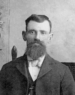


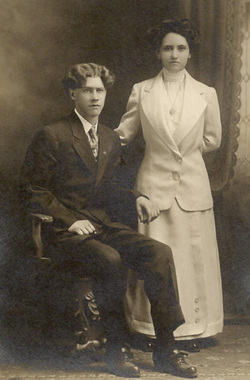
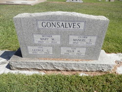
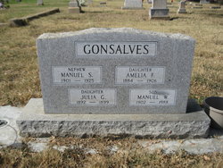
Manuel S Gonsalves
| Birth | : | 24 Oct 1852 Portugal |
| Death | : | 24 Feb 1920 Tehama County, California, USA |
| Burial | : | Abbott Mills Cemetery, Rumford, Oxford County, USA |
| Coordinate | : | 44.4750600, -70.6391900 |
| Description | : | Manuel S Gonsalves was born on St. George Island, Azores. Came to the United States on the ship Constantine and landed at New Bedford, Massachusetts on 8 July 1869. Worked there for two years and came to California on a sailing ship, crossing the Isthmus of Panama on a train and landed at San Francisco in 1871/72. Worked in San Francisco for two months and came north up the Sacramento Valley to Jacinto, Colusa County, where he was employed by Dr. Hugh Glenn who owned 56,000 acres and was the wheat king of the world. Glenn County was named after... Read More |
frequently asked questions (FAQ):
-
Where is Manuel S Gonsalves's memorial?
Manuel S Gonsalves's memorial is located at: Abbott Mills Cemetery, Rumford, Oxford County, USA.
-
When did Manuel S Gonsalves death?
Manuel S Gonsalves death on 24 Feb 1920 in Tehama County, California, USA
-
Where are the coordinates of the Manuel S Gonsalves's memorial?
Latitude: 44.4750600
Longitude: -70.6391900
Family Members:
Spouse
Children


Flowers:


Nearby Cemetories:
1. Abbott Mills Cemetery
Rumford, Oxford County, USA
Coordinate: 44.4750600, -70.6391900
2. Greenleaf Cemetery
Milton, Oxford County, USA
Coordinate: 44.4578018, -70.6016998
3. Rumford Corner Cemetery
Rumford Corner, Oxford County, USA
Coordinate: 44.4955200, -70.6762500
4. Rumford Point Cemetery
Rumford Point, Oxford County, USA
Coordinate: 44.5020760, -70.6725600
5. Rumford Center Cemetery
Rumford Center, Oxford County, USA
Coordinate: 44.5128288, -70.6126785
6. Mount Zircon Cemetery
Rumford, Oxford County, USA
Coordinate: 44.4739710, -70.5693050
7. Whales Back Cemetery
Woodstock, Oxford County, USA
Coordinate: 44.4202200, -70.6507100
8. East Bethel Cemetery
East Bethel, Oxford County, USA
Coordinate: 44.4648500, -70.7210200
9. East Ellis Cemetery
Rumford, Oxford County, USA
Coordinate: 44.5331001, -70.6669006
10. Bird Hill Cemetery
Bethel, Oxford County, USA
Coordinate: 44.4234140, -70.6961680
11. Hanover Cemetery
Hanover, Oxford County, USA
Coordinate: 44.4850006, -70.7332993
12. West Ellis Cemetery
Rumford, Oxford County, USA
Coordinate: 44.5372009, -70.6832962
13. Bartlett Cemetery
East Bethel, Oxford County, USA
Coordinate: 44.4817009, -70.7433014
14. East Rumford Cemetery
Rumford, Oxford County, USA
Coordinate: 44.5203018, -70.5558014
15. Cole Hill Cemetery
Woodstock, Oxford County, USA
Coordinate: 44.3992004, -70.6350021
16. Sunnyside Terrace Cemetery
Rumford, Oxford County, USA
Coordinate: 44.5257988, -70.5541992
17. Chandler Hill Cemetery
Bethel, Oxford County, USA
Coordinate: 44.4392014, -70.7394028
18. Upper West Ellis Cemetery
Rumford, Oxford County, USA
Coordinate: 44.5456009, -70.6941986
19. Mount Abram Cemetery
Greenwood, Oxford County, USA
Coordinate: 44.4025002, -70.7078018
20. South Bethel Cemetery
Bethel, Oxford County, USA
Coordinate: 44.4160995, -70.7363968
21. Robbins Cemetery
Woodstock, Oxford County, USA
Coordinate: 44.4162100, -70.5286220
22. Wyman Cemetery
Rumford, Oxford County, USA
Coordinate: 44.5196991, -70.5152969
23. Lakeside Cemetery
Bryant Pond, Oxford County, USA
Coordinate: 44.3760986, -70.6466980
24. Luther Whitman Cemetery
Bryant Pond, Oxford County, USA
Coordinate: 44.3898300, -70.5643067