

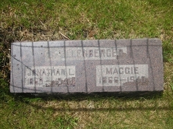
Margaret “Maggie” Graybill Shellenberger
| Birth | : | 20 Dec 1866 |
| Death | : | 4 Jan 1940 |
| Burial | : | Duke Street Cemetery, Southport, Metropolitan Borough of Sefton, England |
| Coordinate | : | 53.6343536, -2.9993131 |
| Description | : | Shellenberger. Maggie, daughter of Michael and Hannah Graybill of Richfield, Snyder Co., Pa., as born Dec. 20, 1866; died at her home in Colorado Springs, Jan. 4, 1940, at the age of 73 y. 14 d. In 1881 at the age of 15 years she moved with her parents to Osborne Co., Kans., where she grew to womanhood. In 1894 she was married to Jonathan Shellenberger of Osborne, Kans. The same year both united with the Mennonite Church. In this faith she lived a consistent life of Christian service to the end and in later years as the wife... Read More |
frequently asked questions (FAQ):
-
Where is Margaret “Maggie” Graybill Shellenberger's memorial?
Margaret “Maggie” Graybill Shellenberger's memorial is located at: Duke Street Cemetery, Southport, Metropolitan Borough of Sefton, England.
-
When did Margaret “Maggie” Graybill Shellenberger death?
Margaret “Maggie” Graybill Shellenberger death on 4 Jan 1940 in
-
Where are the coordinates of the Margaret “Maggie” Graybill Shellenberger's memorial?
Latitude: 53.6343536
Longitude: -2.9993131
Family Members:
Parent

Spouse
Siblings
Children
Flowers:


Nearby Cemetories:
1. Duke Street Cemetery
Southport, Metropolitan Borough of Sefton, England
Coordinate: 53.6343536, -2.9993131
2. Christ Church Churchyard
Southport, Metropolitan Borough of Sefton, England
Coordinate: 53.6327778, -2.9953770
3. Ardwick Cemetery
Ardwick, Metropolitan Borough of Manchester, England
Coordinate: 53.6302778, -2.9900000
4. Holy Trinity Church
Southport, Metropolitan Borough of Sefton, England
Coordinate: 53.6503800, -2.9969150
5. St. Marie on the Sands
Southport, Metropolitan Borough of Sefton, England
Coordinate: 53.6524320, -3.0023440
6. Southport Crematorium
Scarisbrick, West Lancashire District, England
Coordinate: 53.6235810, -2.9600210
7. Emmanuel Parish Church
Southport, Metropolitan Borough of Sefton, England
Coordinate: 53.6604534, -2.9748117
8. Emmanuel Church Garden of Remembrance
North Meols, West Lancashire District, England
Coordinate: 53.6607130, -2.9753420
9. Liverpool Road Cemetery
Birkdale, Metropolitan Borough of Sefton, England
Coordinate: 53.6083620, -3.0257140
10. Sacred Heart RC Cemetery
Birkdale, Metropolitan Borough of Sefton, England
Coordinate: 53.6066100, -3.0270100
11. St Cuthberts Churchyard
Southport, Metropolitan Borough of Sefton, England
Coordinate: 53.6603230, -2.9620310
12. St. Mark Churchyard
Scarisbrick, West Lancashire District, England
Coordinate: 53.6134600, -2.9403800
13. Saint John Crossens Churchyard
Crossens, Metropolitan Borough of Sefton, England
Coordinate: 53.6733410, -2.9478740
14. St. Elizabeth's Churchyard
Scarisbrick, West Lancashire District, England
Coordinate: 53.6124460, -2.9206340
15. St. Cuthbert's Churchyard
Halsall, West Lancashire District, England
Coordinate: 53.5852140, -2.9529650
16. St. Stephen's Churchyard
North Meols, West Lancashire District, England
Coordinate: 53.6813720, -2.9248140
17. St. Peter's Churchyard
Formby, Metropolitan Borough of Sefton, England
Coordinate: 53.5663834, -3.0594721
18. West Lancashire Cemetery and Crematorium
Burscough, West Lancashire District, England
Coordinate: 53.5875500, -2.8820300
19. Our Lady Of Compassion RC Churchyard
Formby, Metropolitan Borough of Sefton, England
Coordinate: 53.5574060, -3.0575020
20. St. Michael and All Angels Churchyard
Great Altcar, Metropolitan Borough of Sefton, England
Coordinate: 53.5507770, -3.0279540
21. St Thomas Churchyard
Lydiate, Metropolitan Borough of Sefton, England
Coordinate: 53.5443480, -2.9621640
22. St Peter and St Paul Churchyard
Ormskirk, West Lancashire District, England
Coordinate: 53.5692640, -2.8877690
23. Christ Churchyard
Aughton, West Lancashire District, England
Coordinate: 53.5583510, -2.9046990
24. Saint Anne's Roman Catholic Church Cemetery
Ormskirk, West Lancashire District, England
Coordinate: 53.5626520, -2.8935560