
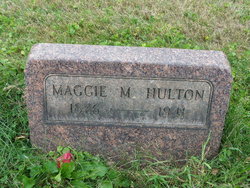
Margaret May “Maggie” Gorby Hulton
| Birth | : | 26 Nov 1876 East Palestine, Columbiana County, Ohio, USA |
| Death | : | 26 Sep 1941 Unity, Columbiana County, Ohio, USA |
| Burial | : | Bath Abbey, Bath, Bath and North East Somerset Unitary Authority, England |
| Coordinate | : | 51.3815310, -2.3586640 |
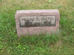
| Description | : | Name: Maggie Hulton Titles & Terms: Death Date: 26 Sep 1941 Death Place: Unity Township, Columbiana, Ohio Birth Date: 26 Nov 1876 Estimated Birth Year: Birthplace: E. Palestine, O. Death Age: 64 years 10 months Gender: Female Marital Status: Widowed Race or Color: Caucasian Street Address: E. Palestine Rd. Occupation: Housewife Residence: Unity, Ohio Burial Date: 29 Sep 1941 Burial Place: Archer Cem. Cemetery Name: Spouse's Name: Chas. Hulton Father's Name: Jos. Gorby Father's Title & Terms: Father's Birthplace: Clay Co., Ind. Mother's Name: Tillie Ward Mother's Titles & Terms: Mother's Birthplace: Rogers, O. Film Number: 2023974 Digital Folder Number: 4057794 Image Number: 1151 Certificate Number: fn 70690 Collection: Ohio Deaths, 1908-1953 |
frequently asked questions (FAQ):
-
Where is Margaret May “Maggie” Gorby Hulton's memorial?
Margaret May “Maggie” Gorby Hulton's memorial is located at: Bath Abbey, Bath, Bath and North East Somerset Unitary Authority, England.
-
When did Margaret May “Maggie” Gorby Hulton death?
Margaret May “Maggie” Gorby Hulton death on 26 Sep 1941 in Unity, Columbiana County, Ohio, USA
-
Where are the coordinates of the Margaret May “Maggie” Gorby Hulton's memorial?
Latitude: 51.3815310
Longitude: -2.3586640
Family Members:
Parent

Spouse
Siblings
Children
Flowers:


Nearby Cemetories:
1. Bath Abbey
Bath, Bath and North East Somerset Unitary Authority, England
Coordinate: 51.3815310, -2.3586640
2. St. Mary de Stall Churchyard (Defunct)
Bath, Bath and North East Somerset Unitary Authority, England
Coordinate: 51.3813350, -2.3600353
3. Quaker Meeting House
Bath, Bath and North East Somerset Unitary Authority, England
Coordinate: 51.3823280, -2.3604380
4. Old Orchard Street Catholic Burial Vault
Bath, Bath and North East Somerset Unitary Authority, England
Coordinate: 51.3800370, -2.3579910
5. Bath General Hospital Burial Ground
Bath and North East Somerset Unitary Authority, England
Coordinate: 51.3824715, -2.3614742
6. Ss Michael & Paul Churchyard
Bath, Bath and North East Somerset Unitary Authority, England
Coordinate: 51.3834970, -2.3596980
7. St James Old Burial Ground
Bath, Bath and North East Somerset Unitary Authority, England
Coordinate: 51.3798600, -2.3610100
8. St. Michael's Burial Ground
Bath, Bath and North East Somerset Unitary Authority, England
Coordinate: 51.3838810, -2.3594090
9. St Mary's Chapel, Queens Square
Bath, Bath and North East Somerset Unitary Authority, England
Coordinate: 51.3827790, -2.3649790
10. Saint Mark's Churchyard
Widcombe, Bath and North East Somerset Unitary Authority, England
Coordinate: 51.3766660, -2.3588010
11. Baptist Burial Ground
Widcombe, Bath and North East Somerset Unitary Authority, England
Coordinate: 51.3764216, -2.3556947
12. St Mary Magdalen Chapel
Widcombe, Bath and North East Somerset Unitary Authority, England
Coordinate: 51.3760486, -2.3643405
13. Old Baptist Burial Ground
Walcot, Bath and North East Somerset Unitary Authority, England
Coordinate: 51.3755070, -2.3544360
14. St. Mary's Churchyard
Bathwick, Bath and North East Somerset Unitary Authority, England
Coordinate: 51.3876120, -2.3543540
15. Abbey & St James' Graveyard for the Poor
Widcombe, Bath and North East Somerset Unitary Authority, England
Coordinate: 51.3753550, -2.3545640
16. St. Swithin Churchyard
Bath, Bath and North East Somerset Unitary Authority, England
Coordinate: 51.3885480, -2.3594500
17. St. John the Baptist Churchyard
Bathwick, Bath and North East Somerset Unitary Authority, England
Coordinate: 51.3886890, -2.3547030
18. Walcot Methodist Chapel Burial Ground
Bath, Bath and North East Somerset Unitary Authority, England
Coordinate: 51.3897080, -2.3579610
19. St. James' Cemetery
Bath, Bath and North East Somerset Unitary Authority, England
Coordinate: 51.3802000, -2.3722200
20. Quaker Burial Ground
Widcombe, Bath and North East Somerset Unitary Authority, England
Coordinate: 51.3744350, -2.3498460
21. St Thomas à Becket's Church
Widcombe, Bath and North East Somerset Unitary Authority, England
Coordinate: 51.3734250, -2.3465560
22. Smallcombe Vale Cemetery
Bathwick, Bath and North East Somerset Unitary Authority, England
Coordinate: 51.3757400, -2.3429400
23. Independent Burial Ground Argyle Chapel
Bath, Bath and North East Somerset Unitary Authority, England
Coordinate: 51.3925420, -2.3536920
24. Unitarian Chapel Burial Ground
Widcombe, Bath and North East Somerset Unitary Authority, England
Coordinate: 51.3704650, -2.3539270