
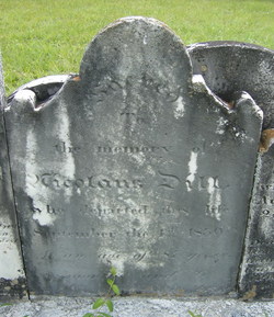
Maria Eva Sell Dill
| Birth | : | 14 Aug 1753 Adams County, Pennsylvania, USA |
| Death | : | 23 Mar 1813 Carroll County, Maryland, USA |
| Burial | : | West Virginia National Cemetery, Pruntytown, Taylor County, USA |
| Coordinate | : | 39.3350190, -80.0730590 |
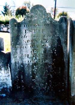
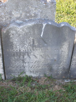
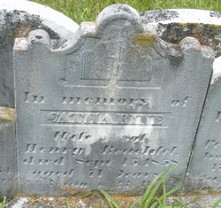
| Description | : | She was born in what is now Union Township, Adams County, PA. She married Nicholas Dill on November 16, 1773. Five years later they purchased her father's farm and agreed to care for her aging parents. Four years later they sold the farm to her brother Adam and moved to near Silver Run, Carroll County, MD. They had four daughters: Esther Koontz, Elizabeth Maus, Hannah Banker and Catherine Bechtel. [Source: Kenneth Sell: The Sell Families of Adams and York Counties, PA.: The Female Lines. Unpublished manuscript, 2010, Chap. 3C, pp. 21-39]. |
frequently asked questions (FAQ):
-
Where is Maria Eva Sell Dill's memorial?
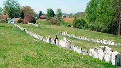
Maria Eva Sell Dill's memorial is located at: West Virginia National Cemetery, Pruntytown, Taylor County, USA.
-
When did Maria Eva Sell Dill death?
Maria Eva Sell Dill death on 23 Mar 1813 in Carroll County, Maryland, USA
-
Where are the coordinates of the Maria Eva Sell Dill's memorial?
Latitude: 39.3350190
Longitude: -80.0730590
Family Members:
Parent
Spouse
Siblings
Children

Flowers:


Nearby Cemetories:
1. West Virginia National Cemetery
Pruntytown, Taylor County, USA
Coordinate: 39.3350190, -80.0730590
2. Beulah Cemetery
Pruntytown, Taylor County, USA
Coordinate: 39.3336590, -80.0817140
3. Abram Smith Cemetery
Pruntytown, Taylor County, USA
Coordinate: 39.3314018, -80.0811005
4. Woodsdale Memorial Park
Pruntytown, Taylor County, USA
Coordinate: 39.3408012, -80.0658035
5. Warder Cemetery
Pruntytown, Taylor County, USA
Coordinate: 39.3360670, -80.0549330
6. Keener Cemetery
Grafton, Taylor County, USA
Coordinate: 39.3502370, -80.0503460
7. Wiseman Cemetery
Pruntytown, Taylor County, USA
Coordinate: 39.3602170, -80.0782840
8. Gawthrop Cemetery
Pruntytown, Taylor County, USA
Coordinate: 39.3292360, -80.1095210
9. Grafton National Cemetery
Grafton, Taylor County, USA
Coordinate: 39.3350296, -80.0312500
10. Carder Cemetery
Fetterman, Taylor County, USA
Coordinate: 39.3618760, -80.0409150
11. Old Catholic Cemetery
Taylor County, USA
Coordinate: 39.3445200, -80.0243000
12. Harmony Grove Cemetery
Grafton, Taylor County, USA
Coordinate: 39.3456001, -80.1267014
13. Mount Calvary Catholic Cemetery
Grafton, Taylor County, USA
Coordinate: 39.3492012, -80.0171967
14. Knotts Cemetery
Grafton, Taylor County, USA
Coordinate: 39.3550030, -80.0170860
15. Lantz Ford Cemetery
Grafton, Taylor County, USA
Coordinate: 39.3219370, -80.0132820
16. Bluemont Cemetery
Grafton, Taylor County, USA
Coordinate: 39.3446999, -80.0121994
17. Reese Cemetery
Grafton, Taylor County, USA
Coordinate: 39.3604990, -80.0068620
18. Walnut Grove Cemetery
Webster, Taylor County, USA
Coordinate: 39.2813988, -80.0472031
19. Brown Cemetery
Taylor County, USA
Coordinate: 39.3841630, -80.0295590
20. Coplin Cemetery
Taylor County, USA
Coordinate: 39.3114570, -80.1469800
21. Old Side Cemetery
Taylor County, USA
Coordinate: 39.3116989, -80.1472015
22. Lawler Cemetery
McGee, Taylor County, USA
Coordinate: 39.3845000, -80.1238000
23. Arnold Cemetery
Grafton, Taylor County, USA
Coordinate: 39.2985115, -80.0014712
24. West Hill Cemetery
Taylor County, USA
Coordinate: 39.2782810, -80.0284830