
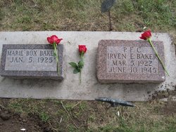

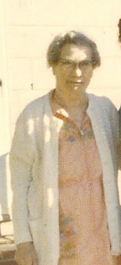
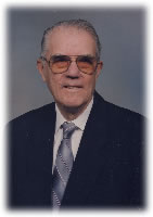
Marie Ella Box Baker
| Birth | : | 5 Jan 1925 Schaller, Sac County, Iowa, USA |
| Death | : | 11 Sep 2010 |
| Burial | : | Old Mission Cemetery, Wichita, Sedgwick County, USA |
| Coordinate | : | 37.7243996, -97.2964020 |
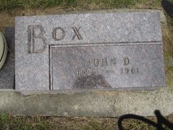
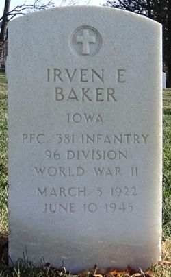
| Description | : | Marie Baker, age 85, of Kansas City, and formerly of Schaller, Iowa died Saturday, September 11, 2010. Marie was born on January 5, 1925 in Schaller, Iowa to parents John and Christine (Hansen) Box. Marie was baptized in the Lutheran Church in Schaller. She was raised in the Schaller area and attended school there. On August 24, 1944, she was united in marriage to Irven E. Baker in Schaller. Shortly after the marriage, Irven was drafted into the Army and was killed in combat on Okinawa on June 10, 1945. Their daughter, Judy was born just 11 days before her father's death.... Read More |
frequently asked questions (FAQ):
-
Where is Marie Ella Box Baker's memorial?
Marie Ella Box Baker's memorial is located at: Old Mission Cemetery, Wichita, Sedgwick County, USA.
-
When did Marie Ella Box Baker death?
Marie Ella Box Baker death on 11 Sep 2010 in
-
Where are the coordinates of the Marie Ella Box Baker's memorial?
Latitude: 37.7243996
Longitude: -97.2964020
Family Members:
Parent
Spouse
Siblings
Flowers:


Nearby Cemetories:
1. Old Mission Cemetery
Wichita, Sedgwick County, USA
Coordinate: 37.7243996, -97.2964020
2. Old Mission Mausoleum
Wichita, Sedgwick County, USA
Coordinate: 37.7242600, -97.2967400
3. Mission Chapel Mausoleum
Wichita, Sedgwick County, USA
Coordinate: 37.7231200, -97.2955100
4. Wichita Park Cemetery and Mausoleum
Wichita, Sedgwick County, USA
Coordinate: 37.7277985, -97.2960968
5. Wichita Hebrew Cemetery
Wichita, Sedgwick County, USA
Coordinate: 37.7201004, -97.2798004
6. White Chapel Memorial Gardens
Wichita, Sedgwick County, USA
Coordinate: 37.7162018, -97.2806015
7. Maple Grove Cemetery
Wichita, Sedgwick County, USA
Coordinate: 37.7036018, -97.2949982
8. Highland Cemetery
Wichita, Sedgwick County, USA
Coordinate: 37.7028008, -97.3007965
9. Temple Emanuel Cemetery
Wichita, Sedgwick County, USA
Coordinate: 37.7014000, -97.3008000
10. Saint James Episcopal Church Columbarium
Wichita, Sedgwick County, USA
Coordinate: 37.6865600, -97.2930000
11. East Heights United Methodist Memorial Garden
Wichita, Sedgwick County, USA
Coordinate: 37.6854100, -97.2845500
12. Shirley Tilford Memorial Garden
Wichita, Sedgwick County, USA
Coordinate: 37.6942700, -97.3359600
13. Saint Stephen's Episcopal Church Columbarium
Wichita, Sedgwick County, USA
Coordinate: 37.6999272, -97.2505590
14. Saint Johns Episcopal Church Columbarium
Wichita, Sedgwick County, USA
Coordinate: 37.6918950, -97.3339670
15. Calvary Cemetery
Wichita, Sedgwick County, USA
Coordinate: 37.6781006, -97.2949982
16. Mount Saint Mary Convent Cemetery
Wichita, Sedgwick County, USA
Coordinate: 37.6704000, -97.2904000
17. Ascension Cemetery
Bel Aire, Sedgwick County, USA
Coordinate: 37.7675018, -97.2533035
18. Lutheran Cemetery
Wichita, Sedgwick County, USA
Coordinate: 37.7664986, -97.2443008
19. Greenwich Cemetery
Wichita, Sedgwick County, USA
Coordinate: 37.7518997, -97.2266998
20. Kensington Gardens Cemetery
Wichita, Sedgwick County, USA
Coordinate: 37.7230988, -97.2040024
21. Pierpont Cemetery
Sedgwick County, USA
Coordinate: 37.7011400, -97.2077500
22. Kechi Township Cemetery
Park City, Sedgwick County, USA
Coordinate: 37.8022003, -97.3000031
23. Lakeview Cemetery & Mausoleum
Wichita, Sedgwick County, USA
Coordinate: 37.7086601, -97.1978989
24. Adorers of The Blood of Christ Convent Cemetery
Wichita, Sedgwick County, USA
Coordinate: 37.6677700, -97.3787800