
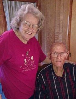
Marie Hall Smith
| Birth | : | 1930 Rutherford County, North Carolina, USA |
| Death | : | 15 Mar 2022 Forest City, Rutherford County, North Carolina, USA |
| Burial | : | Round Hill Baptist Church Cemetery, Union Mills, Rutherford County, USA |
| Coordinate | : | 35.4934690, -81.9711200 |
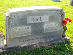
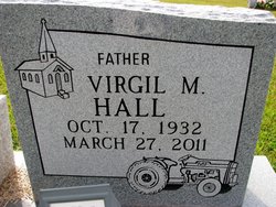
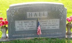
| Description | : | Marie (Hall) Smith 1930 ~ 2022 (age 91) Marie Hall Smith, age 91, of Forest City, died Tuesday, March 15, 2022, at Fair Haven of Forest City. She was the daughter of the late Gilkey Hall and the late Zora Harris Hall. Marie was a native of Rutherford County. She was of the Baptist faith. She loved to grow flowers and raise tomatoes. She also loved to cook and bake. In addition to her parents she was preceded in death by her husband: Joe A. Smith; a son Keith Smith; siblings G.A. Hall, Daniel Hall, Neil... Read More |
frequently asked questions (FAQ):
-
Where is Marie Hall Smith's memorial?
Marie Hall Smith's memorial is located at: Round Hill Baptist Church Cemetery, Union Mills, Rutherford County, USA.
-
When did Marie Hall Smith death?
Marie Hall Smith death on 15 Mar 2022 in Forest City, Rutherford County, North Carolina, USA
-
Where are the coordinates of the Marie Hall Smith's memorial?
Latitude: 35.4934690
Longitude: -81.9711200
Family Members:
Parent

Spouse

Siblings


Flowers:


Nearby Cemetories:
1. Round Hill Baptist Church Cemetery
Union Mills, Rutherford County, USA
Coordinate: 35.4934690, -81.9711200
2. Grace Tabernacle Cemetery
Union Mills, Rutherford County, USA
Coordinate: 35.4957850, -81.9777540
3. Union Hill A.M.E. Zion Church Cemetery
Union Mills, Rutherford County, USA
Coordinate: 35.4850770, -81.9671190
4. Mount Pleasant CME Church Cemetery
Union Mills, Rutherford County, USA
Coordinate: 35.4818800, -81.9592700
5. Flack Family Cemetery
Union Mills, Rutherford County, USA
Coordinate: 35.4765400, -81.9784300
6. Liberty Hill Cemetery
Rutherford County, USA
Coordinate: 35.4791985, -81.9847031
7. Pleasant Hill Cemetery
Rutherford County, USA
Coordinate: 35.5022011, -81.9441986
8. Old Thermal City Church Cemetery
Thermal City, Rutherford County, USA
Coordinate: 35.5173120, -81.9706250
9. Union Mills Presbyterian Church Cemetery
Union Mills, Rutherford County, USA
Coordinate: 35.4824350, -81.9440390
10. Hillsdale Church Cemetery
Rutherfordton, Rutherford County, USA
Coordinate: 35.4849150, -82.0134380
11. Joseph Baxter Cemetery
Union Mills, Rutherford County, USA
Coordinate: 35.4529650, -81.9594860
12. Little White Country Church Cemetery
Rutherfordton, Rutherford County, USA
Coordinate: 35.4487152, -81.9854279
13. Centennial Cemetery
Rutherford County, USA
Coordinate: 35.4655991, -81.9206009
14. Gilkey United Methodist Church Cemetery
Rutherfordton, Rutherford County, USA
Coordinate: 35.4428110, -81.9773740
15. Gilkey Church of God Cemetery
Rutherfordton, Rutherford County, USA
Coordinate: 35.4424690, -81.9790850
16. Piney Ridge C.M.E Cemetery
Rutherfordton, Rutherford County, USA
Coordinate: 35.4467490, -81.9382130
17. Oak Springs Baptist Church Cemetery
Rutherford County, USA
Coordinate: 35.4437990, -81.9396900
18. Camp Creek Baptist Church Cemetery
Union Mills, Rutherford County, USA
Coordinate: 35.5141983, -81.9039001
19. Pine Ridge Mennonite Church Cemetery
Rutherfordton, Rutherford County, USA
Coordinate: 35.4568660, -82.0358090
20. Welcome Home Baptist Church Cemetery
Gilkey, Rutherford County, USA
Coordinate: 35.5118310, -82.0482780
21. Westminister Baptist Church Cemetery
Rutherfordton, Rutherford County, USA
Coordinate: 35.4647750, -81.8927880
22. Gilboa United Methodist Church Cemetery
Rutherfordton, Rutherford County, USA
Coordinate: 35.4236130, -81.9782150
23. Mountain Creek Baptist Church Cemetery
Rutherfordton, Rutherford County, USA
Coordinate: 35.4253006, -81.9985962
24. Brackettown Cemetery
McDowell County, USA
Coordinate: 35.5532990, -81.9207993